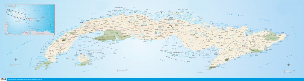
Cuba (full map)
Cuba lies at the western end of the Greater Antilles group of Caribbean islands, which began to heave from the sea about 150 million years ago.Cuba is by far the largest of the Caribbean islands at 110,860 square kilometers. It is only slightly smaller than the state of Louisiana and half the size of the United Kingdom. It sits just south of the Tropic of Cancer at the eastern perimeter of the Gulf of Mexico, 150 kilometers south of Key West, Florida, 140 kilometers north of Jamaica, and 210 kilometers east of Mexico’s Yucatán Peninsula. It is separated from Hispaniola to the east by the 77-kilometer-wide Windward Passage.
Cuba lies within the tropics, though its climate—generally hot and moist—is more properly semi- or subtropical.Cuba is actually an archipelago with some 4,000-plus islands and cays dominated by the main island (104,945 square kilometers), which is 1,250 kilometers long—from Cabo de San Antonio in the west to Punta Maisí in the east—and between 31 and 193 kilometers wide. Plains cover almost two-thirds of the island. Cuba is the least mountainous of the Greater Antilles, with a median elevation of less than 100 meters above sea level.Slung beneath the mainland’s underbelly is Isla de la Juventud (2,200 square kilometers), the westernmost of a chain of smaller islands—the Archipiélago de los Canarreos—that extends eastward for 110 kilometers across the Golfo de Batabanó. Farther east, beneath east-central Cuba, is a shoal of tiny coral cays—the Archipiélago de los Jardines de la Reina—poking up a mere four or five meters from the sapphire sea. The central north coast is rimmed by a necklace of coral jewels—the Jardines del Rey—limned by Cuba’s most beautiful beaches.
Cuba lies within the tropics, though its climate—generally hot and moist—is more properly semi- or subtropical. There are only two seasons: wet (May to November) and dry (December to April), with regional variations.
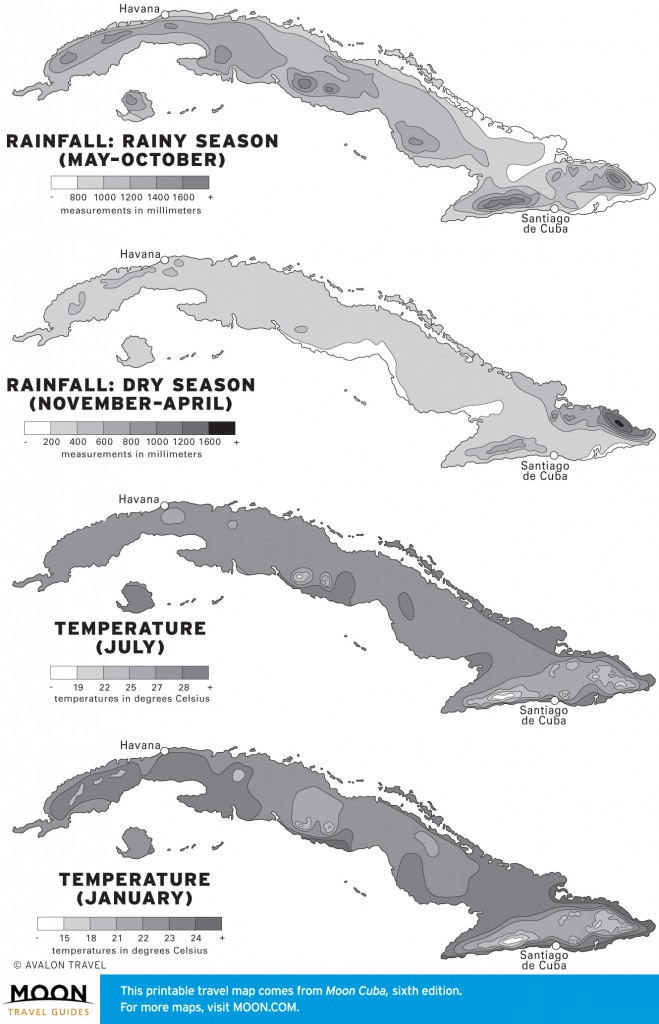
Rainfall in Cuba
The island is influenced by the warm Gulf Stream currents and by the North Atlantic high-pressure zone that lies northeast of Cuba and gives rise to the near-constant brisa, the local name for the trade winds that caress Cuba year-round. Despite its more southerly latitude, Havana, wrote Ernest Hemingway, “is cooler than most northern cities in [July and August], because the northern trades get up about ten o’clock in the morning and blow until about five o’clock the next morning.” Summer months, however, can be insufferably hot and humid.
Read more in this article: “Average Seasonal Weather in Cuba”×Cuba lies within the hurricane belt. August through October is hurricane season, but freak tropical storms can hit Cuba in other months, too. Most hurricanes that strike Cuba originate in the western Caribbean during October and move north over the island. Cuba has been struck by several hurricanes in recent years. In fact, 2008 was one of the worst years in history, with three direct hits in two months. In October 2012, Hurricane Sandy struck Santiago de Cuba, killing 11 people—the worst hurricane in decades.
The country has a highly developed disaster preparedness and exemplary civil defense network for evacuations.
Excerpted from the Sixth Edition of Moon Cuba.