Topography of Terror
TIME : 2016/2/22 11:03:06
Topography of Terror
The Topography of Terror exhibition and documentation center covers the history of terror during the Nazi era. The centers of this national-socialist terror between 1933 and 1945 were the Gestapo and its prison, the SS headquarters, the SS Security Service (SD) and the Reichssicherheitshauptamt (Main Office for State Security). These institutions were located in the immediate vicinity of the Nazi government district, and the history of the crimes originating there is featured at Topography of Terror. There is also a second exhibition that focuses on the role of Berlin as the capital of the Third Reich.
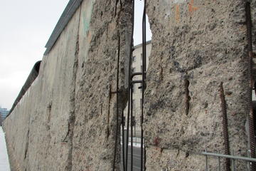
Also on site is one of the few remaining sections of the Berlin Wall. Niederkirchnerstrasse, formerly Prinz-Albrecht-Strasse, formed part of the border between the U.S. and Soviet sectors of Berlin, and the boundary ran along the south side of the street.
The first exhibition was held here in 1987 as part of Berlin's 750th anniversary celebration. Shortly after, the headquarters were excavated, and the site was turned into a memorial and museum. Plans for a new building and permanent exhibition began several years later, and today more than 800,000 people visit Topography of Terror each year.
Practical Info
Topography of Terror is located at Niederkirchnerstrasse 8. Opening hours are from 10 a.m. to 8 p.m. daily, and admission is free.