Madaba Map
TIME : 2016/2/22 11:53:27
Madaba Map
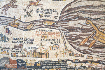
Located in Madaba, the 19th-century Greek Orthodox St. George Church is home to the famous Madaba Map. This sixth-century Byzantine mosaic map is believed to have been created in 542 AD, making it one of the world’s oldest biblical maps. It features imagery of the Holy Land depicted in ornate tiles and was originally made to encompass about 51 feet by 19.5 feet.
The map features more than 150 Greek inscriptions and shows locations like Jericho, the Dead Sea, Palestine, the Nile Delta, Karak and the focus of the map, Jerusalem. Today it’s about one-third its original size, although it is still in excellent condition and worth a visit. It’s said that Muslims once damaged the maps in places where Islam was portrayed as an apostate religion due to offense taken by the fact that the map depicts Jesus as God’s son. The map was unearthed in 1894 AD, and St. George Church was then built over it to act as its protector. Today visitors can see what remains of this beautiful piece of art and history up close. Since its rebirth, the map has not only enthralled church visitors, but has also helped scientists and researchers discover new landmarks and better understand historical topography.
Practical Info
St. George Church is located about 45 minutes from Amman. Photos can be taken inside St. George Church, so you’ll be able to snap pictures of the famous Madaba Map. From Amman, Madaba can be reached via Highway 35 (the King’s Highway). St. George Church is free to enter, and it is open from 8:30 a.m. until 6 p.m. Monday through Thursday and on Saturday. It opens later on Friday and Sunday at 10:30 a.m.