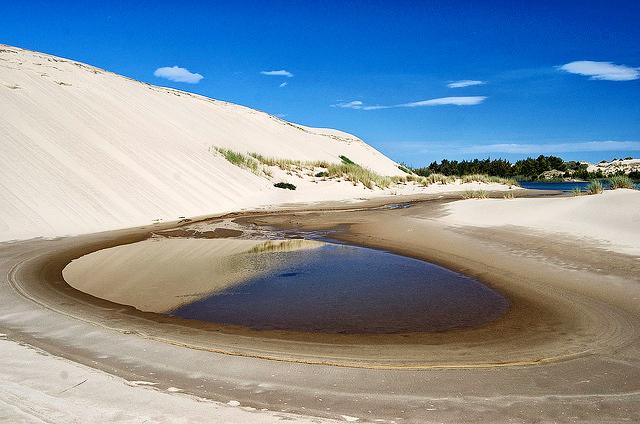
About 50 miles long, but only a couple of miles wide, the Oregon Dunes National Recreation Area stretches along the coast from Coos Bay to Florence. Photo © John Fowler, licensed Creative Commons Attribution.
Even though the 47-mile stretch of U.S. 101 between Coos Bay and Florence does not overlook the ocean, your eyes will be drawn constantly westward to the largest and most extensive oceanfront dunes in the world. Constantly on the move, the shifting sands have engulfed ancient forests, a fact occasionally corroborated by hikers as they stumble on the top of an exposed snag.How did they come to exist in a coastal topography otherwise dominated by rocky bluffs? A combination of factors created this landscape over the past 12,000 years, but the principal agents are the Coos, Siuslaw, and Umpqua Rivers. The sand and sediment transported to the sea by these waterways are deposited by waves on the flat shallow beaches. Prevailing westerlies move the particulate matter exposed by the tide eastward up to several yards per year. Over the millennia, the dunes have grown huge, with some topping 500 feet.Constantly on the move, the shifting sands have engulfed ancient forests, a fact occasionally corroborated by hikers as they stumble on the top of an exposed snag. The cross-section of sand-swept woodlands seen from U.S. 101 demonstrates that this inundation is still occurring. Nonetheless, the motorist gets the impression that the trees are winning the battle because the dunes are only intermittently visible from the road.
The Oregon Dunes National Recreation Area (NRA) is home to more than 400 species of flora and fauna, but the only dangerous animal within this ecosystem is possibly the American teenager. This species migrates here during summer vacation to assault the dunes with a variety of all-terrain vehicles. Of the 31,500 acres within the NRA, nearly half are designated open sand and riding trails for off-highway vehicles such as dune buggies.
Reedsport and the nearby fishing village of Winchester Bay have carved out identities as refueling and supply depots for excursions into Oregon’s Sahara-by-the-Sea. A great place to start your explorations is the Oregon Dunes NRA Visitor Information Center (885 U.S. 101, Reedsport, 541/271-6100), at the junction of the Coast Highway and Highway 38. In addition to the printed information on hiking, camping, and recreation, the Siuslaw Forest Service personnel are very helpful.
Note that a $5 day-use fee is charged per vehicle at most facilities and access points within the NRA. You can purchase an annual pass at the Dunes Visitor Center for $30.
Because the dunes are difficult to see from the highway in many places, the most commonly asked question in the visitors center is “Where are the dunes?” To answer that question for everybody, the National Forest Service opened Oregon Dunes Overlook just south of Carter Lake, midway between Florence and Reedsport, at the point where the dunes come closest to U.S. 101. In addition to four levels of railing-enclosed platforms connected by wooden walkways, there are trails down to the sand. It’s only about 0.25 mile to the dunes and then 1 mile through sand and wetlands to the beach.
You can hike a loop beginning where the sand gives way to willows. Bear right en route to the beach. Once there, walk south 1.5 miles. A wooden post marks where the trail resumes. It then traverses a footbridge going through trees onto sand, completing the loop. If you go in February, this loop has great bird-watching potential. A day-use fee is charged for cars.
Other sites, listed from south to north, for easy introduction to the dune topography are: Spinreel Campground, Umpqua Dunes Trail, Honeyman State Park, and Florence’s South Jetty.
There are three excellent state parks and a dozen Siuslaw National Forest Campgrounds within the NRA. Although joyriding in noisy dune buggies and other off-road vehicles doesn’t lack devotees, the best way to appreciate the interface of ecosystems is on foot. Dunes exceeding 500 feet in height, wetland breeding grounds for waterfowl and other animals, evergreen forests, and deserted beaches can be encountered in a march to the sea. Numerous designated hiking trails, ranging from easy half-mile loops to six-mile round-trips, give visitors a chance to star in their own version of Lawrence of Arabia as they moonwalk through this earthbound Sea of Tranquility. The soundtrack is provided by the 247 species of birds—along with your heartbeat—as you scale these elephantine anthills. Deserted beaches and secret swimming holes are among the many rewards of the journey.
Before setting out, pick up the Hiking Trails Recreation Opportunity Guide from the Oregon Dunes NRA Visitor Center. This and other publications will correct the superficial impression that the dunes are just a domain for all-terrain vehicles and day hikers.
To ensure a bon voyage, it’s important to understand this terrain. Carry plenty of water and dress in layers—there are hot spots in dune valleys and ocean breezes at higher elevations. Expect cool summers and wet mild winters. Although rainfall can average more than 70 inches per year (with 75 percent of it falling Mar.-Nov.), a string of dry 50-60°F days in February is not uncommon. Another surprise is summertime morning fog, brought in by hot weather inland. These fogs, together with the inevitable confusion caused by dunes that don’t look much different from each other, make a compass necessary. The lack of defined trails also compels such measures as marking your return route in the sand with a stick. Binoculars can help with visual orientation, not to mention the bird-watching opportunities galore.