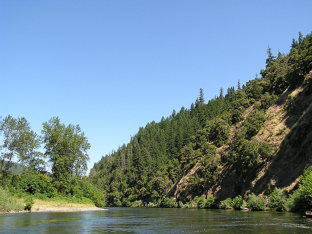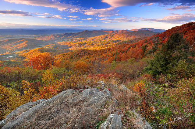
Shenandoah National Park in Virginia. Photo © Kevin Kelley, licensed Creative Commons Attribution.
Shenandoah National Park
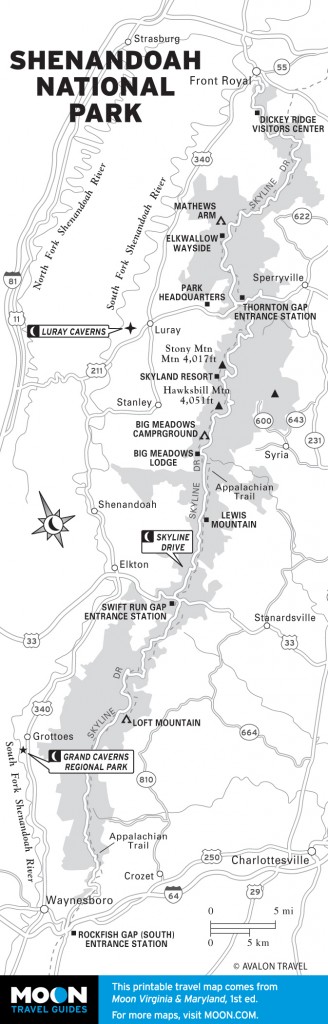
Seventy-five miles west of Washington DC is 200,000 acres of protected parkland known as Shenandoah National Park (540/999-3500, Mar.-Nov. $15 per vehicle or $8 per person, Dec.-Feb. $10 per vehicle or $5 per person, admission good for 7 days). The park is a popular escape for people living in the densely populated areas of Northern Virginia and Maryland offering superb outdoor recreation, stunning mountain scenery, and the Shenandoah River.The park stretches 105 miles from north to south and has four primary entrances: from Front Royal (via I-66 and Route 340), at Thornton Gap (via Route 211), at Swift Run Gap (via Route 33), and at Rockfish Gap (via I-64 and Route 250).
Shenandoah National Park is a prime location for hiking. There are more than 500 miles of trails here, mostly through lush forests. Trail maps are available at entrance stations and visitor centers. The park is also a great place to view wildlife. Some of the resident animals include coyote, black bear, bald eagles, and the timber rattlesnake. Dogs are welcome in the park as long as they are leashed.
There are two visitor centers in Shenandoah National Park. Dickey Ridge Visitor Center (milepost 4.6 on Skyline Drive, open on weekends Apr.-mid-May 9am-5pm and daily mid- May-Nov. 9am-5pm) offers an information desk, restrooms, an orientation movie, maps, permits, first aid, and publications. Harry F. Byrd, Sr. Visitor Center (milepost 51 on Skyline Drive, open on weekends Apr.-mid- May 9am-5pm and daily mid-May-Nov. 9am-5pm) offers an information desk, restrooms, publications, maps, permits, and first aid.
One of the most beautiful stretches of road in the east, Skyline Drive (540/999-3500, Mar.-Nov. $15 and Dec.-Feb. $10 per car) is the most popular attraction in Shenandoah National Park. This 105-mile road takes travelers vista-to-vista along a stunning section of road that runs the entire length of the park from north to south. It is the only public road that goes through the park. Access to Skyline Drive is from four entry points: from Front Royal at the northern terminus (near Routes 66 and 340), at Thornton Gap (Route 211), at Swift Run Gap (Route 33), and near Waynesboro at Rockfish Gap at Routes 64 and 250 (at the southern terminus). Skyline Drive ends where the Blue Ridge Parkway begins. It takes approximately three hours to drive the entire road.
The most popular time to visit Skyline Drive is during the fall foliage. Virginia is known for having one of the most spectacular leaf displays in the country, and this route showcases the best of the best. Unfortunately, this can often mean long lines leading into the park when leaves are at peak. So expect to have a lot of company, especially on a weekend. Inclement weather can also close the road at any time during the year. Call or visit their website for a status if the forecast calls for fog, snow, or heavy rain. The road is also closed at night during deer hunting season (mid-November through early January). Hikers are welcome to come into the park on foot to hike even if the road is closed.
RVs, camping trailers, and horse trailers are allowed on Skyline Drive, but will need to use a low gear. There is also a low tunnel (Marys Rock Tunnel) south of the entrance at Thornton Gap off Route 211 that is 12 feet 8 inches high. The speed limit on Skyline Drive is 35 miles an hour. This is partly because of the curves and steep inclines and partly to protect wildlife in the area.
Mileposts demarcate the entire length of Skyline Drive on the west side of the road starting with 0.0 in Front Royal. All park maps use these as location references.
There are 75 overlooks along the route. Visitors can see the beautiful Shenandoah Valley to the west and the piedmont to the east. Wildflowers and other stunning blooms keep the area colorful throughout the warmer months.
The most popular hike in Shenandoah National Park is Old Rag Mountain. It is also the most challenging and dangerous. A day at Old Rag is an experience to remember as summiting the peak requires a vigorous uphill ascent and many rough areas of scrambling near the top.
The hike is a 9-mile circuit that can take up to seven or eight hours. The route at the top changes periodically but always involves a hefty scramble with good upper body strength. Children and shorter adults may need assistance to get through some sections.
Several search and rescue missions are required each year at Old Rag, but this shouldn’t deter you from the hike. It is a fun way to spend the day and the views from the top are very rewarding. There is a safety video on the park website that should be viewed prior to your hike. Arrive early in the morning to ensure you can get a parking space (especially on the weekends) and bring food and water (at least two quarts per person) with you on your hike. This is a very popular hike and can be crowded on nice days.
Most people arrive at Old Rag Mountain from the eastern park boundary near Sperryville (Route 211). Take Route 522 south for 0.8 mile. Turn right on Route 231 (eight miles). Turn right on Route 601. Continue for three miles and follow the signs to the parking lot. Parking can be tough on weekends. Hikers must use the designated parking area at the Old Rag Fee Station then walk to the trailhead. The small parking lot at the trailhead is not open for public parking. No pets are allowed on parts of the trail since this is not a pet-friendly hike. A valid Shenandoah entrance pass is required.
At milepost 42.6 on Skyline Drive, just south of Skyland Resort, is the parking lot and trailhead for the popular White Oak Canyon hike. This moderate hike offers one of the premier waterfall views in the park and treats hikers to spectacular scenery as they walk down a steep gorge past boulders, pools, and six waterfalls (35-85 feet in height). This hike is steep in sections (there is an elevation gain of 1,200 feet), but the trail is well-used and maintained. It can also be very crowded in peak season. Allow four hours for this 4.8-mile up and back hike.
A scenic, family-friendly hike near Skyline Drive is the 1.5-mile round-trip route to Dark Hollow Falls. The trail begins just north of Big Meadows at mile 50.7. The trail follows the Hogcamp Branch stream out of the Big Meadows spring to the falls. The hike to the 70-foot waterfall is downhill, which means it is uphill on the way back. The trail is especially pretty in the spring when mountain laurel blooms along the path with vibrant pink blossoms. The trail is shaded by the tree canopy, keeping it relatively cool in the summer.
Park-operated lodges and campgrounds in Shenandoah National Park can provide a unique base for exploration. Reservations for prime seasons such as summer and especially during fall foliage (mid-September to mid- October) should be made well in advance. Reservations at many places are accepted up to a year ahead of time.
There are three park-run lodges in Shenandoah National Park. Information on all can be found at goshenandoha.com (877/847-1919). Skyland Resort (open Apr.-Nov., $128-295) is located on 36 acres at the highest point on Skyline Drive (milepost 41.7). The resort sits at an elevation of 3,680 feet and has incredible views of the Shenandoah Valley. Rooms and cabins are available for rent in 28 buildings. Skyland Resort is not luxurious; there are no phones or wireless Internet access in the rooms. It is geared toward the enjoyment of the surrounding nature.
Big Meadows Lodge (open mid-May-Oct., $128-193) is near the center of the park at milepost 51.2. This is the largest developed area of the park, and it is named after a beautiful large meadow near the lodge where deer come to graze. The exterior of the main lodge is made of stones cut from Massanutten Mountain back in 1939, while the interior structure was constructed from chestnut trees (now extinct in the area).
The main lodge at Big Meadows has 29 guest rooms. There is a full service dining room (offering breakfast, lunch, and dinner), a taproom (with light fare and nightly entertainment), and a gift shop at the lodge. Five cabins and six multiunit buildings are also near the lodge.
Big Meadows is close to the Shenandoah River and the Shenandoah Valley. There are no phones or wireless access in the lodge rooms, but free wireless Internet is available in the Great Room of the main building.
Lewis Mountain (open Apr.-mid-Nov., $33- 133) offers cabins and one tent cabin for rent in a quiet wooded setting. Cabins have electricity, private bathrooms, heat, towels, linens, and an outdoor grill pit. There are no phones or wireless access in the cabins. The Shenandoah River and the town of Luray are nearby.
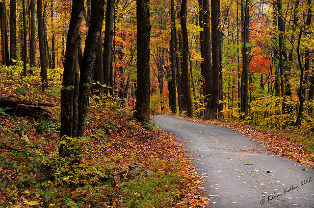
A paved road through the trees in Shenandoah National Park in Virginia. Photo © Kevin Kelley, licensed Creative Commons Attribution.
Most of Shenandoah National Park is open to backcountry camping (a free permit is required). In addition, there are four park-operated campgrounds with a variety of amenities (877/444-6777) that are open spring to fall. They are located at milepost 22.1 (Mathews Arm Campground, mid-May-Oct., $15), milepost 51.2 (Big Meadows Campground, late Apr.-Dec., $20), milepost 57.5 (Lewis Mountain Campground, May-Nov., $15), and milepost 79.5 (Loft Mountain Campground, mid-May-Oct., $15).
Mathews Arm Campground has approximately 178 sites (tent, generator-free, and group sites), restrooms, water, and a trash and recycle center. Big Meadows Campground has more than 200 sites (tent, generator-free, and group sites), restrooms, showers, and a trash and recycle center. Lewis Mountain Campground has approximately 30 tent sites, restrooms, a camp store, and a trash and recycle center. Loft Mountain Campground has more than 200 sites (tent, generator-free, and group sites), restrooms, showers, and a trash and recycle center. Reservations are taken (and advised) at all the campgrounds except Lewis Mountain Campground, which only operates on a first-come, first-served basis.
There are two park-operated dining facilities in Shenandoah National Park. The first is the Pollock Dining Room (dinner entrées $13-25) at Skyland Resort. They serve breakfast, lunch, and dinner and offer regional cuisine (such as rainbow trout and beef tenderloin). Be sure to try the Mile-high Blackberry Ice Cream Pie. The Mountain Taproom is also at Skyland Resort and has family-friendly entertainment and adult drinks. Visitors can also purchase boxed lunches to go. Just ask the hostess for a “picnic to go.”
The second dining facility is the Spottswood Dining Room (dinner entrées $13-23) at Big Meadows Lodge. They are open for breakfast, lunch, and dinner and serve regional cuisine such as roasted turkey and steak. The New Market Taproom is also on-site with live music and specialty drinks.
In addition to the two sit-down restaurants, the park operates three Wayside Food Stops along Skyline Drive. Elkwallow Wayside (milepost 24.1, open mid-Apr.-Oct.) has carryout food in addition to groceries, camping supplies, and gasoline. Big Meadows Wayside (milepost 51.2, open mid-Mar.-mid-Nov.) offers full-service meals (breakfast, lunch, and dinner), groceries, camping supplies, and gasoline. Loft Mountain Wayside (milepost 79.5, open May-Oct.) provides a snack counter, groceries, camping supplies, and gasoline.
A paved road through the trees in Shenandoah National Park in Virginia. Photo © Kevin Kelley, licensed Creative Commons Attribution.
Excerpted from the First Edition of Moon Virginia & Maryland.