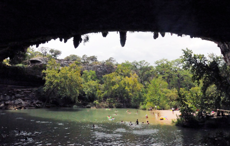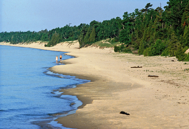
Whitefish Dunes State Park. Photo courtesy of the Wisconsin Department of Natural Resources.
Door County
Some say Whitefish Dunes State Park (920/823-2400), eight miles northeast of Sturgeon Bay, is the most pleasant park in the state system. The beach is indisputably so, with miles of mocha-colored dunes sculpted into ridges by the prevailing winds.Archaeologists surmise that the lakeshore site’s proximity to inland lakes and creeks (nearby Clark Lake is over 800 fish-rich acres) was the primary reason that Native Americans settled here. Eight temporary or permanent encampments and semipermanent villages have been excavated, dating as far back as 100 BC and spreading over three acres that are now within the park. The North Bay people were the earliest, occupying the shores from Green Bay north to Rock Island seasonally until AD 300. The water levels of Lake Michigan rose and flooded the site, and the Heins Creek and Late Woodland people occupied the area AD 500-900; by that time, the itinerant camps had grown into a sizable village. The Oneota people, descended from the Late Woodland people, held sway on the peninsula in two different periods beginning in 900. European settlers arrived in 1840, when a commercial fishing operation on Whitefish Bay was begun by the Clark brothers, who lent their name to the nearby lake, working side by side with the Winnebago people.
Today, everybody comes for the big ol’ dunes.
It’s important to stay off the dunes to protect the fragile flora and microscopic fauna. You will also want to stay on the trail to avoid contact with the abundant poison ivy. Many of the grasses holding together the mounds are unique to this park, and once they’re gone, the dunes will disappear (just take a look at the lifeless gashes created by motorcyclists before the park was established). The park is also the home of the Lake Huron locust, which lives only in Door County. The cooler prevailing winds mean that there is about one month’s delay in flowers blooming compared to the bay side of the county. Rare and threatened plant species include dune goldenrod, dune thistle, dwarf lake iris, and sand reedgrass.
Large wildlife sightings are rare, other than an occasional white-tailed deer or red fox, but there have been occasional reports of black bears.
The dunes here are among the highest on Lake Michigan. They were formed by numerous advances and retreats of ancient lakes and later Lake Michigan as well as countless storms. Sand banks first closed off Clark Lake in what is now the mainland, and as vegetation took hold three millennia ago, wind deposits began piling up atop the sandbar. The result is a microcosm that couldn’t occur on the bay side of the peninsula—a wide beach rising to forested dunes. The tallest, Old Baldy, stands 93 feet high.
Check out the nature center, where all trails start and where you can pick up trail maps, for its exhibits on the geology and anthropology of the area. A Native American village site (10am- 4pm Sat.-Sun. summer) has been recreated just outside to illustrate life during one of the eight periods of human habitation.
There are nearly 15 miles of trails; thoughtfully, the park has a plasticized trail mat on the first hundred yards of all trails to both protect the ground and make it easier for you to trudge. Until you get to the dunes themselves, the park is completely flat. Plank-and-rope boardwalks off the trail allow beach access on the 2.8- mile Red Trail; at the midpoint, it branches away from the water to link with longer trails through mixed hardwood, red pine, and oddball wooded dune areas. The beginning of the Red Trail is also the only place where you can ride a mountain bike. Continuing on the Red Trail to its southern end, hikers can reach the only climbable dune—Old Baldy, which offers panoramas of Lake Michigan and Clark Lake inland. From there, it’s possible to connect to longer trails, including the Yellow Trail, which heads west for another 1.5 miles through a red pine plantation and wooded dune area (very solitary, even for this park) and passing the Red Pine Trail, a 0.5-mile trail through more red pines and a 0.25-mile-long spur trail to Clark Lake.
If you want to start hiking from the other direction, starting from the nature center parking lot, the second-most popular trails after the one to Old Baldy is the 2.5-mile Black Trail, which heads northeast along the limestone bedrock of the Niagara Escarpment and leads to Cave Point County Park, likely the most photographed parkland in Door County. Along the way the trail joins up with an interpretive trail with an anthropomorphic brachiopod (a prehistoric clam-like creature) named Byron who explains the geology of the area.
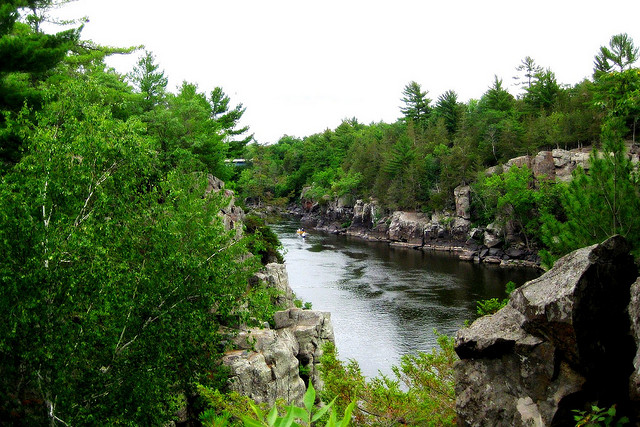
Cave Point is a worthwhile stop. From south to north in Whitefish Bay, the geology shifts from dunes to mixed sand and stone to, at Cave Point, exposed limestone ledges thrusting up to 50 feet above the water on the Niagara Escarpment—the bedrock of the peninsula. Some 425 million years ago, the Silurian Sea covered this entire region, and you can still find fossils in exposed rock. These ledges are on a bowl, the opposite side of which is Niagara Falls. Aeons of crashing waves have hewn caves and cenotes that show up as blowholes as the surf pounds and crashes, echoing like rolling thunder. The whole effect is not unlike the crumbled parapets of a timeworn castle. Sea kayakers have a field day exploring this small promontory. Straight-faced old-timers tell of a schooner that slammed into the rocks at Cave Point in 1881 (true). Laden with corn, the ship cracked like a nut and spilled its cargo (true), and within a few days, corn had mysteriously appeared in Green Bay, on the other side of the peninsula (hmm).
Do not take swimming lightly here. The concave bend of Whitefish Bay focuses all the current, forming tough riptides. Predicting where these form is never entirely possible, and lifeguards are never on duty.
This park is for day-use only, and camping is not allowed. It is great for picnicking, which can be done right atop the limestone ledges overlooking the lake, not to mention along the beaches.
Excerpted from the First Edition of Moon Wisconsin’s Door County.