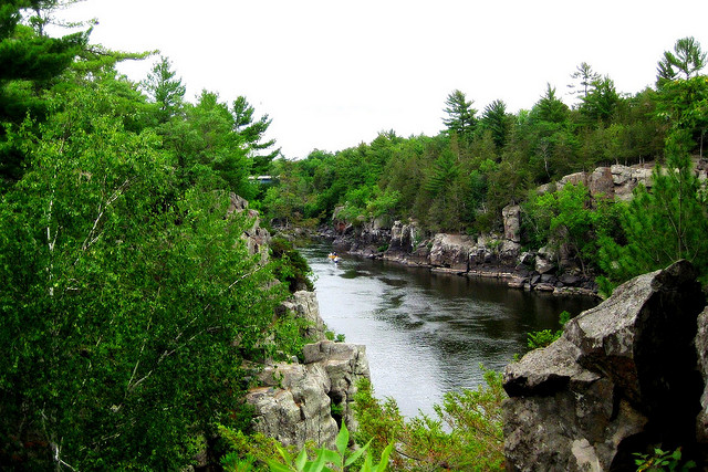
Near Taylor Falls along the St. Croix Riverway, with Minnesota on the left and Wisconsin on the right. Photo © Wendy, licensed Creative Commons Attribution.
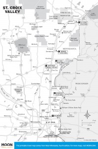
St. Croix Valley
Established in 1968 as one of the original projects in the National Wild and Scenic Rivers System, this 252-mile riverway begins in Wisconsin, where it also encompasses the entire 98-mile Namekagon River. The spring-fed St. Croix flows for 25 miles through the Badger State before becoming a border river. For the most part it’s a narrow, shallow, lazy waterway winding through an often remote ribbon of wilderness — absolutely ideal canoeing territory. There are only occasional Class I rapids (a few of which can rise to Class II during high water), so it makes a leisurely trip, perfect for families. Thanks to the 60-foot-tall St. Croix Falls Hydroelectric Dam, the last 10 miles of the Upper St. Croix are now the Indianhead Flowage; because motorboats are common here, most paddlers take out at Wild River State Park.The river hits the sheer cliffs of the Dalles of the St. Croix at Taylors Falls, and, after a short sprint through the narrow gorge, it spreads its banks and drops its bottom. For the next 50 miles, until it joins the Mississippi, the Lower St. Croix takes its time. The first 20 miles, down to the Apple River, are officially a “slow speed zone” for motorboats and so, despite substantial development along the shore, remain popular with canoes. Beyond the giant sandbar at the Apple’s mouth, the river grows some more, and large motorboats are the primary users. The river is so wide below Stillwater that it is known as Lake St. Croix, and sailboats join their gas-guzzling cousins on the water.
To prevent the spread of zebra mussels, boaters may no longer travel upstream past the High Bridge, about 3.5 miles north of Stillwater. Personal watercraft are also prohibited above Stillwater. Boaters should also read and heed the strict no-wake regulations posted at all landings.
While the canoeing is fantastic, the camping is even better. Over 100 free first-come, first-served campsites are stretched out along the Minnesota section of the riverway. (Get info on campsites managed by the National Park Service.) All sites are marked by a sign and have a fire ring and a pit toilet; most also have a picnic table. The majority are individual sites that allow up to three tents and eight people, though a few designated group sites can accommodate twice as many.
Strict regulations have been enacted to protect the fragile river environment, and since these are always subject to change, it is a good idea to inquire about them before heading out. Currently, campers must use designated sites above Taylors Falls, and there is a three-night limit at each. There are few campsites below Taylors Falls, but camping is allowed for up to seven nights anywhere on federal land (islands only between High Bridge and Stillwater) except the areas immediately south of the Dalles and around the towns of Osceola, Wisconsin, and Marine on St. Croix. Houseboaters may tie up for an overnight stay anywhere below Nevers Dam, but may not build fires or set up tents on the shore. Below Stillwater the riverway is managed collectively by the states, counties, and National Park Service (NPS), and there is little public land and no designated riverway campsites, though some state and county parks have campgrounds. The large delta at Wisconsin’s Kinnickinnic State Park is a favorite with boaters.
The St. Croix Visitor Center (401 Hamilton St. N., St. Croix Falls, 715/483-3284, 8am-4:30pm daily June-Sept., weekdays rest of year) is located in St. Croix Falls, Wisconsin, just across the river from Taylors Falls. They can provide you with maps and information, including a complete list of area outfitters. Interpretive displays cover the St. Croix’s human and natural history.
Excerpted from the Fourth Edition of Moon Minnesota.