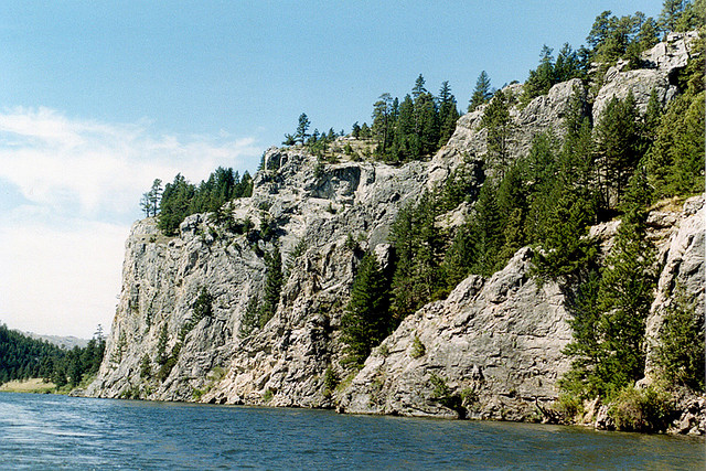
Gates of the Mountains, Montana. Photo © Roger Wollstadt, licensed Creative Commons Attribution.
North of Townsend, three dams in rapid succession impound the Missouri. Because they are near major population centers and are served by good roads, these lakes are among the most popular and developed in Montana. Canyon Ferry, Hauser, and Holter Lakes are well trod by local anglers, boaters, and campers, but they bear up pretty well considering their heavy use.The range of recreational options is boggling: There are 25 state, Bureau of Land Management, and Bureau of Reclamation parks on Canyon Ferry Lake alone, which makes a brief overview difficult. Contact the Department of Fish, Wildlife, and Parks (1420 6th Ave., Helena, 406/444-2535) for more complete information.
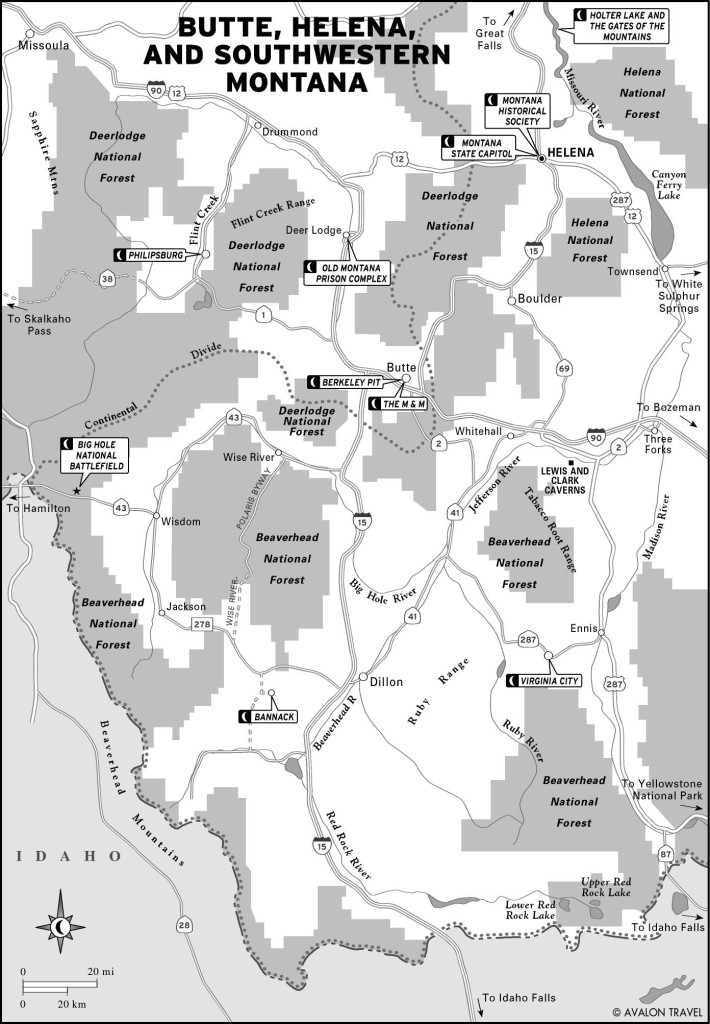
Butte, Helena, and Southwestern Montana
Canyon Ferry Dam was built in the 1950s by the Bureau of Reclamation, creating the largest of the three lakes on the upper Missouri. Canyon Ferry backs up 25 miles of reservoir with almost 80 miles of shoreline. At the south end nearest Townsend, the lake is widest and the surrounding countryside rolling, gentle, and treeless. To the north the reservoir narrows and begins to flow into a steep canyon.
On the east side of the lake, about 18 miles north of Townsend, is a sharp ravine in the Big Belt Mountains called Confederate Gulch. In 1864 a couple of Confederate soldiers discovered incredibly rich gravel beds here. While it lasted, individual pannings yielded up to $1,000 in gold. A boomtown surged up immediately; called Diamond City, it grew to 10,000 people and was as rowdy and tough as the economics and the era allowed. By the 1870s the gold played out, but one last blast with a huge water-cannon-like hydraulic sluice dislodged another million dollars in gold. Today, almost nothing remains of the fabulously rich workings of Confederate Gulch.
Today, however, there is popular fishing and boating at Canyon Ferry. The lake is heavily and regularly stocked with rainbow trout, and they are usually hungry and scrappy enough to make a lucky angler feel skilled. Most of the facilities, both public and private, cluster at the northern end of the lake.
Follow Canyon Ferry Road (or Montana Avenue) east nine miles out of Helena to reach the lake. If coming north on Highway 12, turn on Highway 284 eight miles north of Winston. Rent a boat or windsurfing equipment at Yacht Basin Marina (3555 W. Shore Rd., 406/475-3440).
On the southern end of the lake, the campgrounds thin out. The most convenient campsites are at Silo, seven miles north of Townsend on Highway 12, where there are both public and private campgrounds.
Built in 1908 by Montana Power, Hauser Dam is named for Samuel Hauser, an early Montanan who advocated damming the Missouri to harness electricity for regional mining enterprises. At this 3,720-acre lake, heavily used for boating and waterskiing, the fishing is OK for smallmouth bass and kokanee salmon.
There are two scenic, practically adjacent public campgrounds on Hauser Lake. If the beach at White Sandy, seven miles northeast off I-15 on Highway 453, is full, then continue a few yards farther to Black Sandy.
While at Hauser Lake, try your hand at sapphire mining. The Spokane Bar Sapphire Mine (5360 Castles Rd., 406/227-8989), 10.5 miles east of Helena via York Road, offers buckets of sapphire-laden gravel. Here the novice can wash gravel to discover highly colored sapphires as well as garnets, rubies, and gold. Buckets of gravel from the sapphire mine costs $25–75, and it’s best to come equipped with a screwdriver and tweezers, essential tools of the gravel mining trade.
Holter Lake is the most awe-inspiring of the three upper Missouri Lakes. Behind the dam lies the Gates of the Mountains, so named by Meriwether Lewis:
July 19th, 1805: This evening we entered the most remarkable clifts that we have yet seen. These clifts rise from the waters edge on either side perpendicularly to the hight of 1,200 feet. Solid rock for the distance of 5¾ miles. I entered this place and was obliged to continue my rout until sometime after dark before I found a place sufficiently large to encamp my small party; from the singular appearance of this place I called it the gates of the mountains.
The Missouri cut a deep gorge through thick deposits of limestone; although the flooding of Holter Dam (built in 1913) has decreased the rush of the river through these gates, it is still a startlingly dramatic landscape of geologic and human history. Wildlife viewing, historical vignettes, geologic curiosities, and drop-dead beautiful riverscapes make this one of Montana’s most compelling side trips.
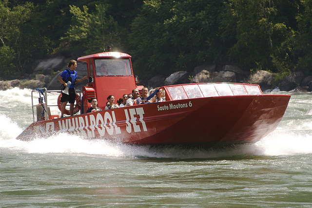
Gates of the Mountains (406/458-5241), two miles east from the Gates of the Mountains exit off I-15, offers guided open-air riverboat tours (Memorial Day–Sept., $14 adult, $12 senior, and $8 child) of the entire canyon. During the two-hour trip, travelers usually see bighorn sheep, mountain goats, eagles, ospreys, and deer. Guides point out Indian pictographs along the limestone cliffs. The departure schedule is complex; call or check the website for times.
Plan your day carefully, and disembark from the boat at Meriwether Picnic Area. The boat captains allow passengers to break the trip at this point. Here at the site of Lewis and Clark’s 1805 camp are trails that lead up into the Gates of the Mountains Wilderness Area, a 28,560-acre wildlife reserve within the deep limestone canyons along the east side of the Missouri River. It was back in this remote and precipitous area that 16 young firefighters died in 1949, a tragedy that led to the writing of Norman Maclean’s best-selling book Young Men and Fire.
If you lay over at the wilderness area, be certain to know when to expect a returning riverboat, and save your ticket stub.
Known simply as The Bungalow (406/235-4276 or 888/286-4250, $125–145), Charles Power’s 1911 country lodge is now one of Montana’s most historically significant bed-and-breakfasts, located near the small town of Wolf Creek in the Gates of the Mountains canyon country. Charles Power was one of the engines of early Montana capitalism. Beginning rather humbly as a trader at Fort Benton in the 1870s, by the time of his death Powers owned 95 different corporations, controlled four square blocks of downtown Helena (including Helena’s most architecturally significant, the Power Block), and was one of the state’s richest men. When it came time to build a country home, Power turned to Robert Reamer, the architect who designed the Old Faithful Lodge in Yellowstone Park. For furnishings, Power turned to young interior designer Marshall Fields. Many of the original furnishings remain in the stately log lodge, which offers four guest rooms (one with private bath).
There are three public campgrounds along Holter Lake, all on the east side. Turn south from I-15 at the Wolf Creek exit, cross Wolf Creek, then turn north (left) on Recreation Road and proceed a few miles to the bridge. Turn south on Bear Tooth Road after crossing the Missouri. Continue three miles to Holter Lake State Park. Four miles up the same road are Log Gulch and Departure Point State Parks.
Excerpted from the Eighth Edition of Moon Montana.