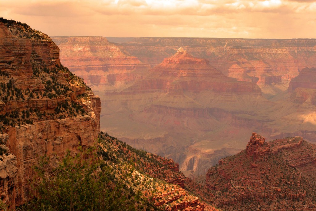
Along the South Rim of Grand Canyon. Photo © Chee-Onn Leong/123rf.
Grand Canyon National Park sprawls over more than 1,900 square miles, but it’s the 40-mile stretch along the South Rim that draws the most visitors.It’s been that way since 1894, when miner John Hance guided the first tourists into the canyon’s depths. A lot has changed since then, but the most popular pursuits endure: traveling to overlooks for theatrical sunsets, hiking or riding a mule into the canyon, and marveling at starry night skies and wildlife.
Even on a busy summer day, when 10,000 visitors crowd the roads and sidewalks, it’s possible to find a contemplative perch along the canyon’s rim.The hub for South Rim activities is Grand Canyon Village, home to lodges, gift shops, Mather Campground, and a general store that stocks everything from toothpaste to tents. The village’s historic district surrounds the train depot, built by the Santa Fe Railway, whose spur line began carrying passengers to the South Rim in 1901.Today, five million people arrive every year—by train, bus, car, and bicycle—giving the village a worldly ambience. Grab an ice cream cone at Bright Angel Lodge or wander the Rim Trail to Lookout Studio, and you’re as likely to hear German or Japanese as English. You might watch a Navajo rug weaver at work or go on a nature walk guided by a ranger who grew up in a Hopi village. You can hike all day, then enjoy a white-tablecloth dinner at El Tovar, see an art exhibit at Kolb Studio or, during September’s Grand Canyon Music Festival, listen to a chamber quartet.
To this rich cultural mix, add the local critter population: elk and mule deer wandering through the ponderosa pines at dawn, ravens eyeing unattended picnics or packs, or a skunk skulking through the parking lot at night. The South Rim offers a wide spectrum of experiences, along with spectacular views, fascinating history, comfortable lodging, and wilderness only a few steps away.
Even on a busy summer day, when 10,000 visitors crowd the roads and sidewalks, it’s possible to find a contemplative perch along the canyon’s rim. Minutes or even hours pass pleasantly, with limestone as your backrest and the canyon spread out at your feet as you watch cloud shadows chase each other across an infinity of cliffs.
South Rim
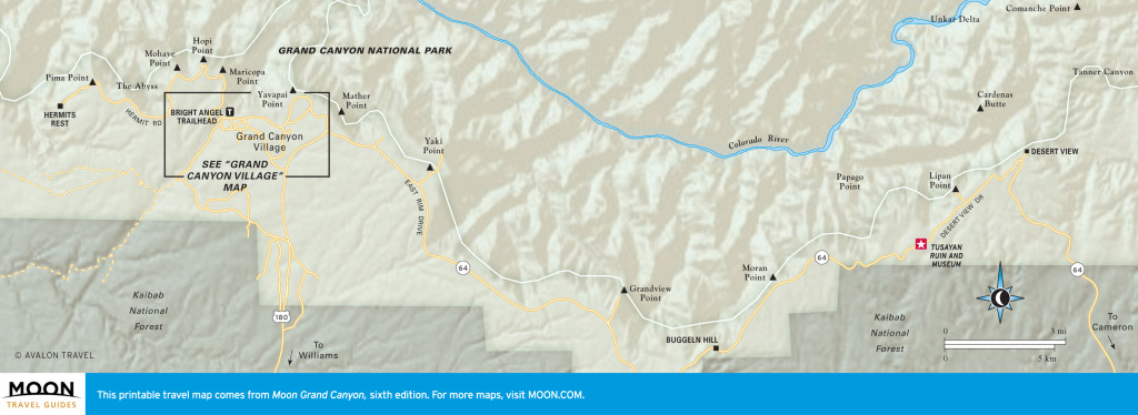
A quick note of orientation: The park’s South Rim is further delineated into the West Rim, including the Grand Canyon Village area west to the end of Hermit Road, and the East Rim, beginning where Highway 64 turns east and ending at Desert View. The East Rim is generally higher, cooler, and less visited than the West Rim, well worth the additional 2–6 hours it takes to explore this side of the canyon.
You can sample the South Rim in two days, but a week allows time for a hike or two, a mule trip, and a leisurely exploration of the overlooks east and west of Grand Canyon Village. You can access the South Rim from either the south or the east, and it’s possible to plan a loop route through Flagstaff. If you arrive from one direction and return in the other, you’ll see a lot more of the Grand Canyon region, including the Navajo Reservation, Wupatki and Sunset Volcano National Monuments, the San Francisco Peaks, and the Route 66 towns of Flagstaff and Williams.
Set aside at least an hour or two during your visit to explore Grand Canyon Village. History and architecture buffs will want to spend even longer admiring the village’s landmark structures, including El Tovar lodge, the train depot, and Lookout Studio. Buildings and sidewalks are most crowded during the afternoon, when tour buses unload and the train pulls into the station, so consider taking your village walking tour after dinner. Most of the gift shops, including historic Hopi House and Kolb Studio, are open late. Beware of slipping into the dreaded village shuffle, though. You’ll know you’ve succumbed when you find yourself staring zombielike at a gift-shop selection of polished rocks for the third time that day.
The remedy? Remember that the main attraction is the canyon itself. From east to west, overlooks are scattered along the rim like beads on a string, each offering a different perspective on the complex network of tributaries and temples that make up Grand Canyon. It helps to memorize a few landmarks, like Vishnu Temple, Plateau Point, or the Battleship, then watch how they seem to reshape themselves as distance or daylight changes.
You could easily spend two to four hours exploring the views west of the village, taking the Hermit Road shuttle or walking along sections of the gentle Rim Trail. For the best photos and fewest crowds, time your visit to the overlooks along Hermit Road for early morning. Sunsets are also dramatic, and crowds gather for the show like they would for an openingnight symphony performance.
East Rim overlooks are less crowded, and you have the option of touring them in your own vehicle, although you could also choose a guided motor-coach tour. (The exception is Yaki Point, closed to private vehicles yearround.) Although it’s just 30 miles from the village to Desert View, the easternmost overlook, you’ll need at least two hours to explore this section of the park. Sunrise and sunset panoramas of the eastern canyon and the river’s broad Unkar Delta are especially good from Lipan Point or Desert View. Archaeology buffs will enjoy the guided walk of Tusayan Ruins, and kids will love climbing the watchtower at Desert View.
If you want to get to the bottom of the canyon, you’ll need at least two days for mule riders or strong hikers, longer if you plan to explore some of the canyon’s length. Corridor trails are the best choice for those new to hiking or to the canyon. Wilderness trails require backcountry skills and are best attempted in three days or more. Advance planning is essential, and backcountry permits go quickly for popular areas.
Do not attempt to hike from the rim to the river and back in one day. Park rangers rescue about 400 people a year in Grand Canyon, most of whom have overestimated their abilities. Dayhike destinations such as the Bright Angel resthouses, Dripping Springs, Ooh Aah Point, Cedar Ridge, and Horseshoe Mesa are scenic, historic, and most definitely geologic. Though permits aren’t required for day hikes, you still need to plan ahead to ensure you have adequate water, salty snacks, and sun protection. The myriad warnings about hiking in the canyon are meant to help you prepare, not to dissuade you. Walking below the rim, even a short distance, takes you into a different realm where your senses seem fresh and new and the world seems very, very old.
In summer, temperatures along the rim are pleasant, topping out in the 80s. Because of low humidity and high elevation, daytime and nighttime temperatures can vary 30°F or more, so plan to wear layers and shed them by midday. On summer afternoons, temperatures below the rim can rise above 100°F, so plan your outdoor activities for early in the day. Afternoon thunderstorms are likely in July and August.
Spring and fall are usually ideal for outdoor activities, though the weather can change quickly. Hang on to your hat—sometimes literally. Sudden wind gusts can catch you by surprise, especially along overlooks.
The South Rim is open year-round, and winter hikes into the canyon might start in ice and snow, making trails treacherous, before leading into pleasant low-desert temperatures along the Colorado River.
Most winter precipitation lands on the South Rim between December and March, but snowstorms can strike anytime from November through May, occasionally making travel difficult. Closed roads usually reopen within a day or two, giving you access to a wonderland of pines embellished by snow and icicles.
Excerpted from the Sixth Edition of Moon Grand Canyon.