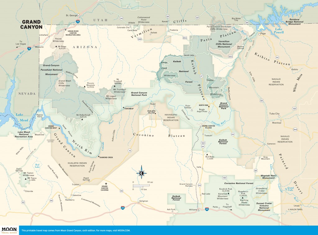
Grand Canyon Overview
Get an overview of the different regions within Grand Canyon to plan your trip. Learn what the South Rim has to offer that the North Rim doesn’t as well as information on the towns that serve as the park’s gateways.
The South Rim, the most visited area of Grand Canyon National Park, extends roughly 40 miles from Hermits Rest to Desert View. More than a dozen scenic overlooks offer views of the canyon and its maze of tributaries and monuments. Among them, Mather Point grants most visitors their first-ever canyon view. Grand Canyon Village bustles with lodging, dining, shopping, and activities from bicycle tours to star parties. Architect Mary Colter’s eccentric buildings perch along the rim, and several hikes, including historic Bright Angel Trail, lead into the canyon’s depths.
Read more about the South Rim →
The North Rim, accessible spring through fall, is 1,000 feet higher than the South Rim and more remote. Only 1 in 10 park visitors travels to the North Rim, where Grand Canyon Lodge and the park’s campground offer accommodations on Bright Angel Point. Scenic Cape Royal Drive leads to Point Imperial and Angel’s Window, with stops for picnicking and hiking along the way. Jacob Lake is the nearest town, about 30 miles from the park’s entrance station. The North Rim’s mixed boreal forests include fir, spruce, and aspen, and remote forest roads lead to canyon overlooks, open meadows, and trails.
Accessible only on foot, by mule, or by boat, the inner canyon contains tall buttes and monuments, hidden waterfalls, and dozens of tributary canyons, all linked by the Colorado River. The river drops nearly 2,000 feet on its 277-mile journey from Lees Ferry to Lake Mead, churning close to 200 rapids. The dangerously hot desert environs of the Inner Gorge are relieved by oases like Bright Angel Creek, where historic Phantom Ranch offers the only lodging and dining in the canyon’s heart.
The rims and tributaries of Grand Canyon extend beyond national park boundaries into lands managed by the Forest Service and Bureau of Land Management or held by the Havasupai, Hualapai, and Navajo tribes. The Havasu Canyon, Grand Canyon Skywalk, historic Lees Ferry, and Marble Canyon overlooks all lie beyond the boundaries of the park but share the essence of Grand Canyon. Though exploring remote areas sometimes requires a high-clearance vehicle or a permit, those who want to escape the crowds will be rewarded with lonely vistas, rich cultural traditions, and landscapes that vary from stark plateaus to dense forest.
Flagstaff, Williams, Page, Fredonia, and Kanab are more than convenient gateways. The mountain town of Flagstaff combines urban pleasures with a dazzling array of outdoor activities. Williams will delight train buffs and Route 66 fans. At Page, Lake Powell’s sandstone canyons lure boaters and backpackers alike. Fredonia and Kanab straddle the Arizona-Utah border, making an ideal jumping-off point not only to the North Rim but also to Zion, Bryce Canyon, and other national parks and monuments on the Southwest’s Grand Circle.
Excerpted from the Sixth Edition of Moon Grand Canyon.