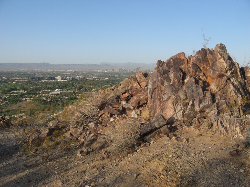
The Mohave Trail is a short and slightly intense hike with a big payoff of views to the south. Photo © Lilia Menconi.
The Piestewa summit may dominate the skyline of the Phoenix Mountains Preserve, but many may not know there’s another, smaller summit nearby. If you want a climb to a view but don’t want to get hung up by the crowds on the Piestewa Summit Trail, Mohave could be your baby.
As the trail continues to climb for the next 0.2 mile, be aware of unofficial trails spurring from Trail 200. When in doubt, continue to favor the option to the right, remaining in a southwest direction.That said, the hike is quite brief. At only 1.2 miles round-trip, it’s finished before you know it. But don’t let the low mileage mislead you—this trail is no piece of cake. With a quick elevation climb of 300 feet, the huffing and puffing comes on fast.The Mohave Trail trailhead sits on the east side of Squaw Peak Drive, just north of the Mohave picnic area, and is easily accessed by a small parking lot on the east side of the street. If you choose to park near the picnic ramadas, look to the north side of the lot for signs that lead you to the Mohave Trail 200, which is just a short walk away.
Once on Trail 200, the path quickly turns south as you march up a gradual incline. Continue past the wood hitching rack to encounter a fork in the trail at 0.2 mile. Veer right to remain on Trail 200 heading southwest. As the trail continues to climb for the next 0.2 mile, be aware of unofficial trails spurring from Trail 200. When in doubt, continue to favor the option to the right, remaining in a southwest direction.
At just over 0.4 mile, follow a couple sharp-turned switchbacks. Here, it’s easy to lose sight of the trail. Stop, stand on your tippy-toes or a rock, and you can soon
find the path again. Most likely, you probably just hit a sharp turn.
The final 0.2 mile is a short climb that heads southwest until you come upon a large pile of stones surrounding a metal post. This marks the end of your short journey. Catch your breath, wander around the summit area, and take in this generous view, looking south to midtown Phoenix with South Mountain Park in the distance.
The return trip is merely a matter of retracing your steps and descending your way back to the parking lot.
Summiting the Mohave Trail 200 could make a great finish to a longer trek by combining it with Trail 202. Start on Trail 200, only this time take a left onto Trail 202 at 0.2 mile, heading south and then east. Follow Trail 202 for 1 mile until it runs into Trail 8A. Turn around here and retrace your steps along Trail 202 for the return mile until you reunite with Trail 200. Now, turn left onto Trail 200 heading southwest. It’s just a short 0.4 mile to the summit from here. To return, simply retrace your steps along Trail 200, heading northwest for a return leg of 0.6 mile. This option totals 3.2 miles.
From downtown Phoenix, take I‑10 east toward Tucson for approximately 2 miles. Take exit 147B to merge onto AZ‑51. Follow it north for 5.5 miles. Take exit 5 for Glendale Avenue. Turn right, heading east onto Glendale Avenue. Continue as Glendale Avenue becomes Lincoln Drive. Follow Lincoln Drive for 0.3 mile and turn left, heading northeast, onto Squaw Peak Drive for 0.8 mile, through the Phoenix Mountains Park and Recreation Area entrance gate (2701 East Squaw Peak Dr.) and past the Mohave picnic area. The small Mohave Trail 200 parking lot and trailhead is on the right (east).
There is no fee. Dogs on leash are allowed. Maps are available online at www.phoenix.gov/parks. For more information, contact City of Phoenix Parks and Recreation Main Office, Phoenix City Hall, 200 West Washington Street, 16th Floor, Phoenix, AZ 85003, 602/262-6862.
Excerpted from the First Edition of Moon Take a Hike Phoenix.