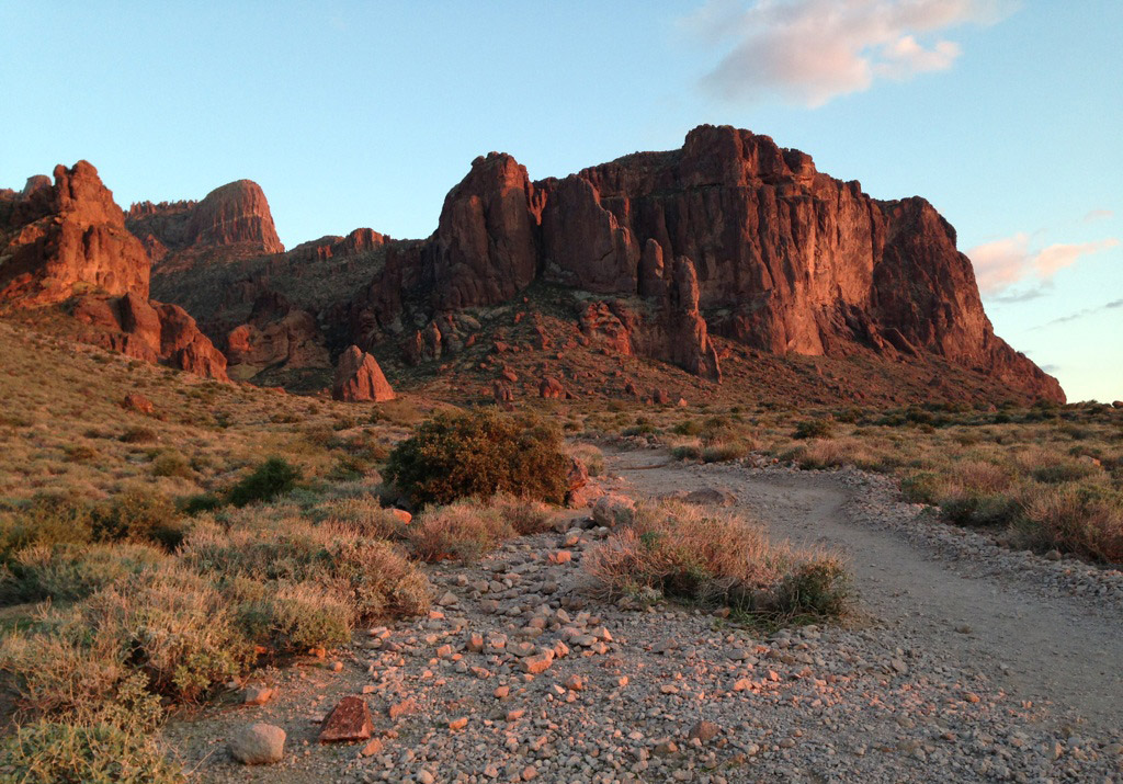
See the flat rock on the left? That’s your final destination. It’s called the Flatiron and it will blow your mind. Photo © Lilia Menconi.
The hike has an innocent beginning as you enter the trail at the Siphon Draw trailhead (on the southwest end of the parking lot) and follow a small portion of the Discovery Interpretive Trail heading south. At 0.2 mile, turn left (east) to follow signs leading to Siphon Draw Trail. At 0.5 mile, pass a large kiosk with the park map and veer southeast to follow the official start of the Siphon Draw Trail. From here, make a subtle elevation gain of 1,100 feet spread over the next 1.5 miles.
By mile 2, you’ve reached the base of the mountain and are greeted by a smooth rock basin carved by rain drainage. This beautiful, shaded basin marks the beginning of the Siphon Draw Canyon and the start of possibly the most rewarding hike of your life. Put on your gloves because you’ll need them as you start pawing at the rough rocks for the next 0.7 mile, during which you ascend 1,650 feet. Ouch. This consumes so much energy, it feels like 5 miles even to the fittest hiker.
The trail is not maintained for this stretch and follows a shallow drainage path straight up the side of the mountain. Be sure to make calculated moves as you follow spray-painted arrows and dots that mark the way. Remember to lean into the rock as you climb and take your time. There are a few tricky spots that most experienced hikers have no trouble clearing. But just before you reach the final stretch to The Flatiron at 2.6 miles, you run smack into a 12-foot rock face. There’s only one way to clear this: Go up. Move slowly, using the cracks in the rock to anchor and wedge your feet. There’s also a very handy (and sturdy) tree on the left side that makes for a much-needed grip. Once this rock face is cleared, there’s just a few more feet of not-scary-at-all-by-comparison scrambling before the trail suddenly enters a serene clearing at 2.7 miles. You can finally stand upright to follow this easy bit of trail for the next 0.2 mile as it traces the edge of the mountain and leads west to the top of The Flatiron.
The top of The Flatiron is a wide clearing littered by low-lying agave, prickly pear, and buckhorn cholla. It. Is. Breathtaking. Lose your mind as you walk all over the flat top of rock and gaze at the impossibly miniature city to the west. To the east, you’re equally blown away by this high-perched view of the rocky peaks and ridges that stretch as far as the eye can see into the Superstition Mountains. It’s nuts. It’s just totally nuts.
Once you’ve regained your composure, scarfed a snack, and snapped some photos of your journey to the top of the world, turn back and retrace your steps. Get down on your butt and use your hands to lower yourself during the scrambling descent. Once you return to the smooth rock basin, it’s a mere 2-mile walk back to the trailhead.
There you have it. You just completed the best hike of your life.
The Siphon Draw Trail ends at 2 miles and makes for a perfect stopping place (perfect, that is, if you’re not in the mood for the best hike of your life). Simply stop at the smooth rock basin. This version makes for a shorter total of 4 miles and skips the scrambling to the top of The Flatiron. Still, the hike climbs up approximately 1,100 feet and makes for a worthy experience as you stop at the gorgeous base of the mountains and the dramatic rock basin.
From downtown Phoenix, take I‑10 east for approximately 5 miles. Take a slight right onto eastbound US‑60 and go east for 24.7 miles. Take exit 196 for Idaho Road (eastbound AZ‑88) and follow the exit ramp for 0.4 mile. Turn left onto Idaho Road and go north for 2.3 miles. Make a slight right onto Apache Trail (still AZ‑88) and go northeast for approximately 5 miles. Turn right at the sign for the Lost Dutchman State Park. Pay the fee at the park entrance and continue for 0.7 mile, following the signs for Siphon Draw trailhead as the road curls south, then west. Park in the westernmost parking lot and find the Siphon Draw trailhead on the southwest corner of the lot.
There is a fee of $7 per vehicle. An annual pass is available for $75. Dogs on leash are allowed. Maps are available at the park gate; there is a visitors center (8am-4pm daily) and a gift shop. For more information, contact the Lost Dutchman State Park, 6109 North Apache Trail, Apache Junction, AZ 85119, 480/982-4485.
Excerpted from the First Edition of Moon Take a Hike Phoenix.