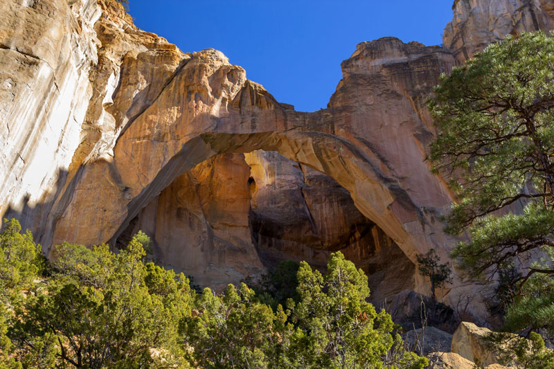
La Ventana Arch in El Malpais National Monument. Photo © Martina Roth/123rf.
The product of three volcanic events, the lava-strewn landscape of the El Malpais National Monument (505/783-4774, free) is not exactly the barren terrain el malpaís (el-mal-pie-EES, literally, the badlands) suggests. A surprising amount of greenery has taken root in the millennia since the last eruption, between 2,000 and 3,000 years ago, and in the spring, wildflowers stand out against the jagged black rock. The lava fields are riven with deep, cave-like tubes that formed as the hot rock cooled. Some of the most scenic areas are along the monument’s eastern border, where the lava meets red sandstone cliffs, as well as New Mexico’s largest natural arch.For those who just want a quick look, the easiest access point is Sandstone Bluffs Overlook, where, on a short walk along the edge of the eastern cliffs, you can admire the lava fields, and see north to Mount Taylor. It’s about 11 miles south from I-40 on Highway 117. Drive another 7 miles to reach La Ventana Arch, a great sandstone arc; a short trail leads to a scenic viewing spot.
If you’d like a longer hike or drive into the park, stop first at the Northwest New Mexico Visitors Center (1900 E. Santa Fe Ave., 505/876-2783, 9am-6pm daily in summer, 8am-5pm daily in winter), near I-40 at exit 85, midway between the two highways that access different parts of the badlands. National Park Service employees can give you detailed maps and current conditions, and from there you can decide whether to take Highway 53 or Highway 117 south into the monument area. The monument information center (505/783-4774, 8am-4:30pm daily) is less conveniently located on Highway 53, 23 miles south of I-40.
In addition to the hikes detailed below, there are more demanding but worthwhile places to explore outside the borders of the national park, in the BLM land designated Cebolla Wilderness (off the southeast border of the park) and West Malpais Wilderness (to the south and west)—ask at the visitors center for details on these areas as well.
By far the most strenuous hike, the shadeless 7.5-mile Zuni-Acoma Trail cuts across the lava beds roughly along the path used for centuries by the Puebloans in this region. It’s rough going because the ground is so uneven, but if you’re interested in the plants and animals that thrive in El Malpais, this can be a rewarding trek. The eastern trailhead is on Highway 117, before you reach La Ventana Arch; the western one is on Highway 53.
For the best up-close look at the lava, head farther south on Highway 117 to the Lava Falls Area. Here you can still make out the swirls and eddies of the molten stuff as if it had cooled yesterday; the variety of shapes and textures is fascinating, as are the odd pockets of stunted trees that manage to flourish here. The three-mile route (a mile-long loop with a one-mile spur) is marked only by rock cairns, so bring a compass, as it’s easy to get disoriented.
At the El Calderon Area on Highway 53, a three-mile loop trail heads to El Calderon Cinder Cone, the area around the lava vent, and then back to the parking lot via a dirt road. Calderon Crater, the oldest of the three lava flows that make up the area, dates back some 115,000 years—as a result, the rock is more weathered, and not the stark black found around younger McCartys Crater. This is also the area where lava tubes are closest to the road—a short walk from the car reveals the entrance to Junction Cave, a tube that partially collapsed—you see a sliver of daylight on the other end. The famous Bat Cave, less than a mile from the parking area, still has a circling cloud of the nocturnal critters at sunset, though not as many as in the past.
The Big Tubes Area, a network of 17 miles of lava caves on the west side of the monument, has by far the weirdest terrain, but it was closed at the time of research, again due to the bat fungus. Even if it does reopen, you’ll need a high-clearance truck to get here, as well as headlamps (with extra batteries), sturdy boots, and heavy work gloves to protect your hands from the jagged rocks.
A family-run tourist attraction that was grandfathered in when El Malpais was made a national monument, the Bandera Crater Ice Caves (Hwy. 53, 888/ICE-CAVE, 9am-5pm daily Mar.-Oct., 9am-4pm daily Nov.-Feb., $11) are an impressive natural sight, especially during the heat of summer, when you can descend from 90°F outside to 31°F underground, the chill emanating from a permanent layer of greenish ice at least 20 feet thick. Although the same phenomenon is visible elsewhere in El Malpais (for much less money), this is the most accessible spot, and generally more impressive. The other half of the attraction, Bandera Crater, 750 feet deep, is actually not much to look at—literally, just a big hole in the ground.
Excerpted from the Ninth Edition of Moon New Mexico.