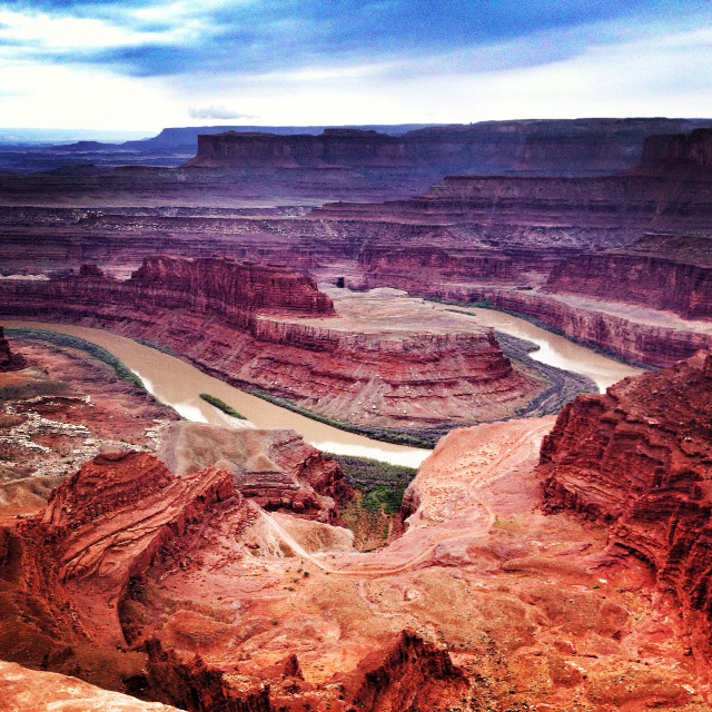
Dead Horse Point State Park in Utah. Photo © Heidi Pillard, used with permission.
Just east of Canyonlands National Park’s Island in the Sky District and a short drive northwest of Moab is one of Utah’s most spectacular state parks. At Dead Horse Point (435/259-2614, day-use $10 per vehicle), the land drops away in sheer cliffs, and 2,000 feet below the Colorado River twists through a gooseneck on its long journey to the sea. The river and its tributaries have carved canyons that reveal a geologic layer cake of colorful rock formations. Even in a region with impressive views around nearly every corner, Dead Horse Point stands out for its exceptionally breathtaking panorama. You’ll also see below you, along the Colorado River, the result of powerful underground forces: Salt, under pressure, has pushed up overlying rock layers into an anticline. This formation, the Shafer Dome, contains potash that is being processed by the Moab Salt Plant. You can see the mine buildings, processing plant, and evaporation ponds, which are tinted blue to hasten evaporation. Even in a region with impressive views around nearly every corner, Dead Horse Point stands out for its exceptionally breathtaking panorama.A narrow neck of land only 30 yards wide connects the point with the rest of the plateau. Cowboys once herded wild horses onto the point, then placed a fence across the neck to make a 40-acre corral. They chose the desirable animals from the herd and let the rest go. According to one tale, a group of horses left behind after such a roundup became confused by the geography of the point. They couldn’t find their way off and circled repeatedly until they died of thirst within sight of the river below. You may also hear other stories of how the point got its name.Besides the awe-inspiring views, the park also has a visitors center (8am-6pm daily mid-Mar.-mid-Oct., 9am-5pm daily mid-Oct.—mid-Mar.), a very popular campground, a picnic area, a group area, a nature trail, hiking trails, and great mountain biking on the Intrepid Trail System. Spectacularly scenic hiking trails run along the east and west rims of the peninsula-like park; hikers are also allowed to use the Intrepid trails. Rangers lead hikes during the busy spring season and on some evenings during the summer, including monthly full-moon hikes. Whether you’re visiting for the day or camping at Dead Horse Point, it’s best to bring plenty of water. Although water is available here, it is trucked in.
Dead Horse Point is easily reached by paved road, either as a destination itself or as a side trip on the way to the Island in the Sky District of Canyonlands National Park. From Moab, head northwest 10 miles on U.S. 191, then turn left and travel 22 miles on Highway 313. The drive along Highway 313 climbs through a scenic canyon and tops out on a ridge with panoramas of distant mesas, buttes, mountains, and canyons. There are several rest areas along the road.
Excerpted from the First Edition of Moon Arches & Canyonlands National Parks.