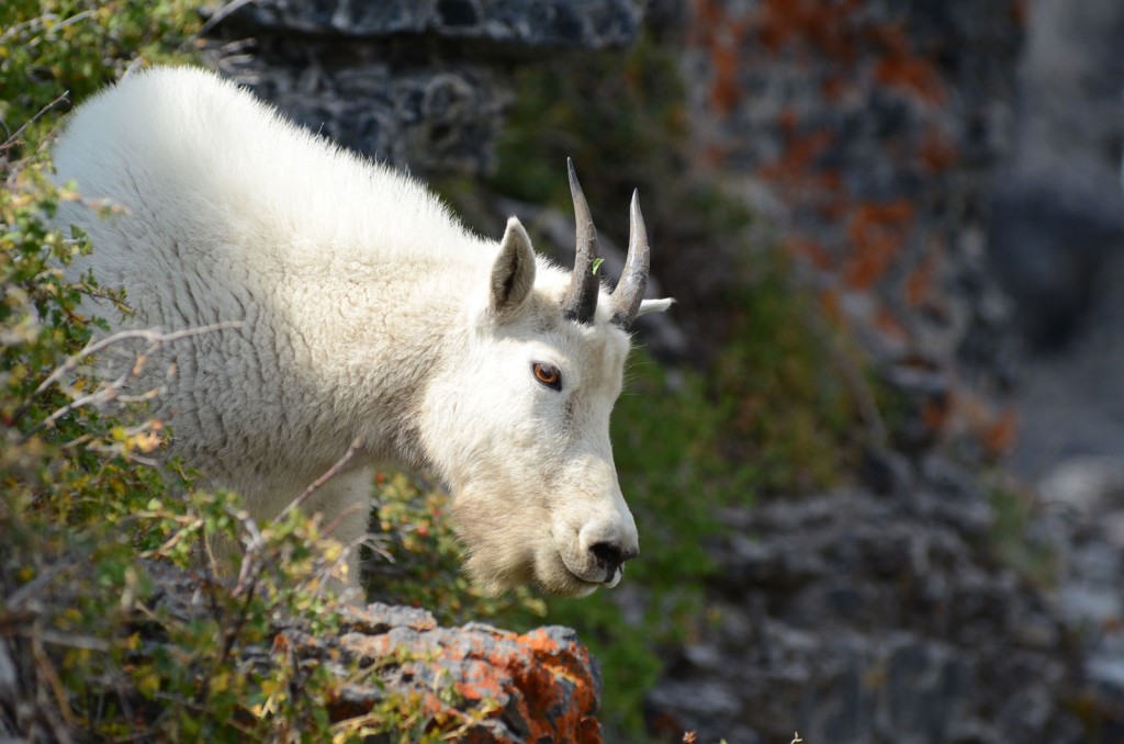
Keep an eye out for the herd of Timpanogos goats. Photo © Mike Matson.
The Timpooneke Trail leaves the Timpooneke Campground trailhead and heads into the thick forest. Engelmann spruce and other evergreens shade the trail for the first 0.5 mile as it starts climbing along a gentle grade. The trail opens up above a wide meadow on the valley floor and traverses above the west side for 0.4 mile. At 1 mile you’ll cross the first in a series of small streams trickling across the trail. Then at 1.4 miles, there’s a signed junction for Scout Falls. Go left, and walk less than 100 yards to check out the moss-lined falls cascading over a limestone ledge. Turn right to continue up the trail.
The trail climbs up the first major step in the Giant Staircase at 2 miles. Willows and thick vegetation cover the valley floor. By 3 miles the trail is crossing a giant, sweeping talus field. The trail continues on a steady incline, weaving through stunted subalpine fir trees and Indian paintbrush. At the 4-mile mark, views start to open up to the north of Box Elder Peak and Lone Peak.
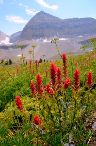
Indian paintbrush blooming on the Timpooneke Trail. Photo © Mike Matson.
Enter Timpanogos Basin at 4.4 miles. A trail leading to Emerald Lake and the Aspen Grove Trail breaks off on the left as you enter the basin. Indian paintbrush, asters, bluebells, fireweed, and lupine bloom in a stunning display during the midsummer months. Look along the steep cliff bands for the Timpanogos herd of mountain goats. This herd of at least 40 goats can usually be spotted somewhere along this upper half of the trail.
At 5.5 miles the trail reaches an 11,000-foot pass. Step through this rocky gap onto the west side of the ridge and continue climbing toward the rocky summit. The route traverses broken limestone slopes to the south before climbing along the ridge to the peak’s apex. On the summit, an old metal hut with a red triangular roof welcomes hikers.
Enjoy the all-encompassing summit views. To the east you’ll see Emerald Lake directly below, the 10,993-foot Roberts Horn, and Deer Creek Reservoir in the distance. To the north are the major summits of the central Wasatch. In the west, the towns of Pleasant Grove and Provo stretch across the Utah Valley floor to Utah Lake. And in the distance to the south is Mount Nebo, the only summit higher than Mount Timpanogos in the Wasatch Range.
Consider leaving a car at the Aspen Grove trailhead and hiking up Timpooneke Trail and down the Aspen Grove Trail for a one-way adventure. It helps keep this long trail interesting the whole way!
From Salt Lake City drive south on I-15 for 25 miles to Exit 284 for Alpine/ Highland and then drive east on Highway 92 for 16 miles. Turn right onto the Timpooneke Road for the Timpooneke Campground. Drive past the entrance to the campground loop and turn left into the trailhead parking lot.
There is an American Fork Canyon fee of $6 for a three-day pass, $12 for a sevenday pass, or $45 for an annual pass. The America the Beautiful pass is accepted here. Dogs on leash are allowed. For more information, contact the Pleasant Grove Ranger District,Uinta-Wasatch-Cache National Forest, 390 North 100 East, Pleasant Grove, UT 84062, 801/785-3563.
Excerpted from the First Edition of Moon Take a Hike Salt Lake City.