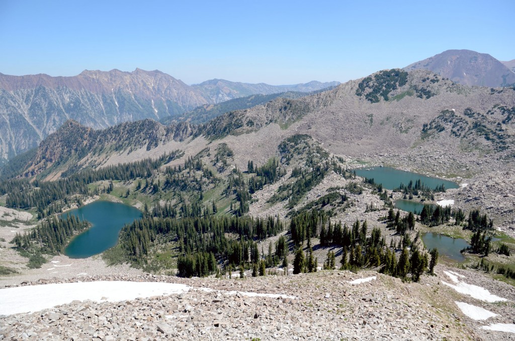
Red Pine Lake (left) and Little Red Pine Lake (right) from the shoulder of the Pfeifferhorn. Photo © Mike Matson.
To continue on to the summit of the Pfeifferhorn, traverse around the left side of Red Pine Lake. Cross over the small stream and continue up the steep forested slope south of the lake. The boulder field to the left leads to upper Red Pine Lake, but to reach the Pfeifferhorn it’s better to stay right in the spruce and subalpine fir. At 3.6 miles you’ll reach a small alpine lake, or glacier tarn. The trail heads right from this lake, directly up the steep ridge. Climbing along this rocky ridge, the views go from impressive to spectacular, looking down to Red Pine Lake in the foreground and Twin Peaks of Broads Fork across Little Cottonwood Canyon to the north. At 3.9 miles you’ll have gained the steep ridge and get your first glimpse of the Pfeifferhorn. Now at 10,900 feet and well above tree line, the grand scale of the Wasatch high country is spread out below you in all directions.
If it weren’t for the enticing summit of the Pfeifferhorn, also called the Little Matterhorn, beckoning to the west, simply reaching this ridge-top vantage point would probably satisfy most adventure seekers. Gaining the ridge opens up views to the south that stretch from the impressive summits of Box Elder Peak and Mount Timpanogos to the distant Utah Lake on the valley floor and beyond to the western horizon. From here follow the ridgeline west toward the pyramid-shaped Pfeifferhorn. This is a good place to identify the shallow gully on the southeast side of the Pfeifferhorn’s rock cone; it is the easiest route to the summit. It is possible to follow the ridgeline all the way to this gully—scrambling across rocks and around rocks if necessary. And there is some exposure if you decide to stay on the apex of the ridge. Although no technical-climbing skills or ropes are necessary, you should be comfortable with exposure and move very carefully along this route. To avoid the exposed, scrambling option, drop down to the south side of the ridge and traverse the base of the rock spine. This option doesn’t have the exposure, but it’s not any easier than staying on the high route. Reaching the gully at 4.35 miles, scramble up the steep slope or up a steep snowfield, depending on the snowpack, to the summit. Trekking poles are a huge help anywhere above Red Pine Lake, but are worth their weight in gold on this final leg of the climb. The 11,326-foot summit of the Pfeifferhorn is a majestic spot. If conditions are right, it’s the perfect place to enjoy a well-earned lunch. The views are incredible and include the peaks in Snowbird Ski Resort—Twin Peaks of American Fork, Mount Baldy, and Hidden Peak.
At 2.5 miles from the parking lot a side trail branches off the Red Pine Lake Trail leading to Maybird Gulch. Maybird Gulch offers more solitude than Red Pine Lake as well as views of the Pfeifferhorn.
From Salt Lake City drive east on I-80 for 5 miles and merge onto I-215 South. Continue 6 miles and take Exit 6 for 6200 South. Turn left at the light at the bottom of the off-ramp and drive 1 mile south on 6200 South until it becomes Wasatch Boulevard. Continue driving south 3 miles to the base of Little Cottonwood Canyon. Continue straight onto Little Cottonwood Road (Route 210) and drive 5.5 miles to the White Pine trailhead parking lot on the right side of the road.
There is no fee. Little Cottonwood Canyon is a watershed and dogs are not allowed. Maps are available at the Public Lands Information Center, 3285 East 3300 South (inside REI), Salt Lake City, UT 84109, 801/466-6411. For more information, contact Salt Lake City Ranger District, Uinta-Wasatch-Cache National Forest, 125 South State Street, Salt Lake City, UT 84138, 801/236-3400.
Excerpted from the First Edition of Moon Take a Hike Salt Lake City.