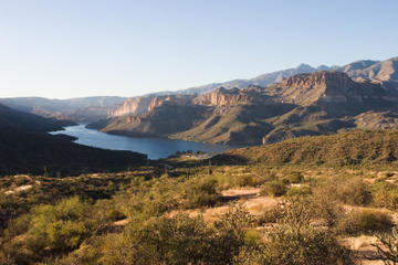
Apache Trail is a 120 mile (193km) historic road that connects Apache Junction (the east edge of the Phoenix metropolitan area) to Theodore Roosevelt Lake. Although the trail’s official name today is “State Route 88”, it adopted the name “Apache Trail” in reference to the Apache Indians who originally inhabited the Superstition Mountains. The road was initially built as a way to open copper trade between the city of Globe and the Phoenix area. Today, however, it has become a very popular tourist destination. Winding through the Superstition Mountains, this circular road provides some of the most beautiful scenic views in central Arizona. It guides you up and down the steep desert mountains, past cliff dwellings, lake shores, eroded canyons, and old mining towns.
In addition to simply enjoying the beautiful scenery, many travelers choose to stop and explore the various historic treasures along the way. You can go hiking in The Lost Dutchman State Park, fishing at Canyon Lake, or get lunch and shop at the old west ghost town, Tortilla Flat. Apache Trail is a beautiful and easy way to experience the majestic Arizona desert, and with so many places to stop along the way, there’s something to do for everyone!
Choose to take the “Apache Trail Circle Route,” an 80-mile (129 km) loop that begins at Apache Junction, a city that is about 45 minutes (35 miles/56 km) from downtown Phoenix. The route circles past Roosevelt Lake, heads south to Globe and Miami, then loops back towards Apache Junction.The drive usually takes a full day to complete, however you can choose to stay overnight in order to spend more time hiking, camping, and exploring the desert. It is important to note though that there are still various portions of the trail that are unpaved. The desert’s rough terrain and steep cliffs require visitors to take extra caution when driving.