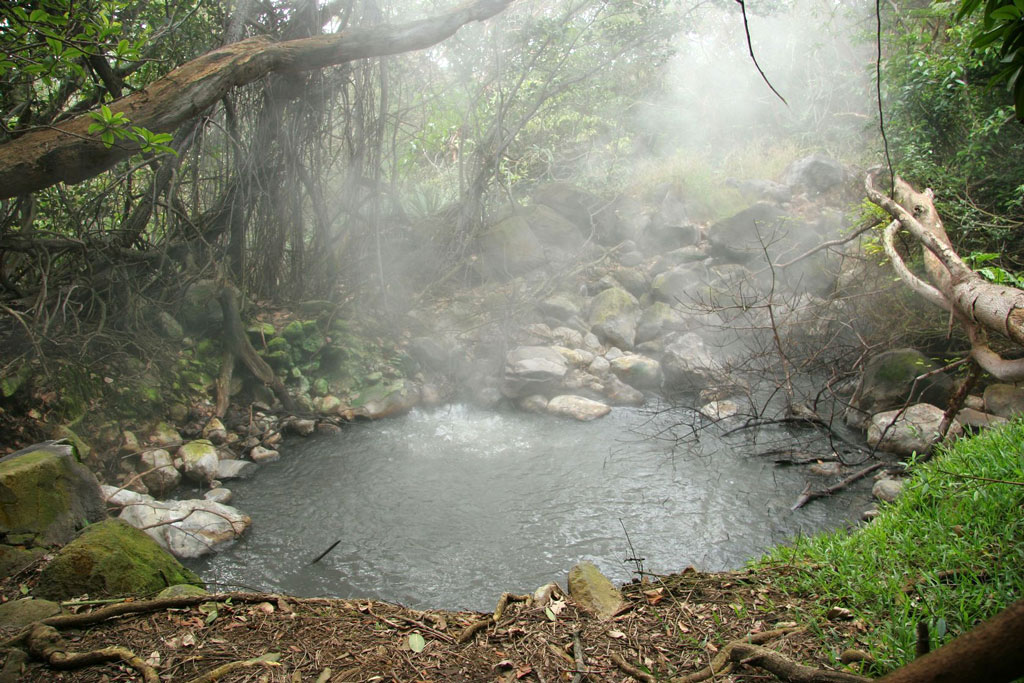
Steam rises from one of Parque Nacional Rincón de la Vieja’s geothermal springs. Photo © Brian Lasenby/123rf.
Guanacaste and the Northwest
Parque Nacional Rincón de la Vieja, an active volcano in a period of relative calm, is the largest of five volcanoes that make up the Cordillera de Guanacaste. The volcano is composed of nine separate craters, with dormant Santa María (1,916 meters/6,286 feet) the tallest; its crater harbors a forest-rimmed lake popular with tapirs. The main crater—Von Seebach—still steams; it features Linnet Bird Lagoon, to the southeast of the active volcano. Icy Lago Los Jilgueros lies between the two craters. The last serious eruption was in 1983, but occasionally the park is temporarily closed, most recently in 2006, due to volcanic activity. The national electricity company has a geothermal plant, Planta Las Pailas, just below the Las Pailas Ranger Station.The 14,083-hectare (34,800-acre) Parque Nacional Rincón de la Vieja extends from 650 to 1,916 meters (2,133-6,286 feet) in elevation on both the Caribbean and Pacific flanks of the cordillera. The Pacific side has a distinct dry season (if you want to climb to the craters, Feb.-Apr. is best); by contrast, the Caribbean side is lush and wet year-round, with as much as 500 centimeters (200 inches) of rainfall annually on higher slopes. The park is known for its profusion of orchid species. More than 300 species of birds include quetzals, toucanets, the elegant trogon, three-wattled bellbirds, and the curassow. Mammals include cougars; howler, spider, and white-faced monkeys; and kinkajous, sloths, tapirs, tayras, and even jaguars.
The lower slopes can be explored along relatively easy trails that begin at the two ranger stations. The Sendero Encantado leads through cloud forest full of guaria morada orchids (the national flower) and links with a 12-kilometer (7.5-mile) trail that continues to Las Pailas (The Cauldrons), 50 hectares (124 acres) of bubbling mud volcanoes, boiling thermal waters, vapor geysers, and Las Hornillas fumaroles, a geyser of sulfur dioxide and hydrogen sulfide. Be careful when walking around: It is possible to step through the crust and scald yourself, or worse.
Between the cloud forest and Las Pailas, a side trail (marked “Aguas Thermales”) leads to soothing hot-sulfur springs called Los Azufrales (The Sulfurs). The 42°C (108°F) thermal waters form small pools where you may bathe and take advantage of their curative properties. Use the cold-water stream nearby for cooling off. Another trail leads to the Hidden Waterfalls, four continuous falls, three of which exceed 70 meters (230 feet), in the Agria Ravine.
You’re restricted to hiking one trail at a time, and must report to the ranger station before setting out on each subsequent trail. If you don’t report back, rangers set out to find you after a specified time.
The summit hike is relatively straightforward but challenging. You can do the roundtrip to the summit and back in a day with a very early start. The trail begins at the Santa María Ranger Station (the 19th-century farmstead was once owned by former U.S. president Lyndon B. Johnson, who sold it to the park service), leads past Las Hornillas and the Las Pailas Ranger Station (the best place to start—it’s four hours from here), and snakes up the steep, scrubby mountainside. En route, you cross a bleak expanse of purple lava fossilized by the blitz of the sun. Trails are marked by cairns, though it is easy to get lost if the clouds set in; consider hiring a local guide. The upper slopes are of loose scree and very demanding. Be particularly careful on your descent (3 hours).
From on high, you have a splendid view of the wide Guanacaste plain shimmering in the heat…It can be cool up here, but the powerful view and the hard, windy silence make for a profound experience. From on high, you have a splendid view of the wide Guanacaste plain shimmering in the heat like a dream world between hallucination and reality, and beyond, the mountains of Nicoya glisten like hammered gold from the sunlight slanting in from the south. On a clear day, you can see Gran Lago de Nicaragua. Magical! You have only the sighing of the wind for company.It will probably be cloudy. Bring waterproof clothing and mosquito repellent. The grasses harbor ticks and other biting critters, so wear long pants. Fill up with water at the ranger station, which sells maps ($2).
Camping is not permitted, except at Santa María Ranger Station ($2 pp), which has bath and shower facilities; bring a sleeping bag and mosquito netting. You can buy groceries at a small store immediately below the ranger station at Las Pailas.
The park is open 7am-5pm Tuesday-Sunday, and last entry is 3pm. The headquarters is at Hacienda Santa María, about 27 kilometers (17 miles) northeast of Liberia. It contains an exhibition room. However, the main access point to the park is the Las Pailas Ranger Station (tel. 506/2200-0399), on the southwestern flank of the volcano. Admission costs $10; you need to provide your passport number.
The road to the Santa María Ranger Station begins from the Barrio Victoria suburb of Liberia (a sign on Hwy. 1 on the south side of Liberia points the way to Sector Santa María), where Avenida 6 leads east 25 kilometers (16 miles) past the ranger station entrance to the hamlets of San Jorge and Colonia Blanca (which can also be reached by a dirt road from Guayabo, north of Bagaces). The road is deeply rutted, and muddy in wet season; a 4WD vehicle is recommended. Santa María is linked to Las Pailas by a six-kilometer (4-mile) trail and by a dirt road that passes through private property ($1.50 toll).
Las Pailas is also reached off the Pan-American Highway via a dirt road from Curubandé. The turnoff is about six kilometers (4 miles) north of Liberia, from where the dirt road leads past the village of Curubandé (at 10 kilometers/6 miles) to the gates of Hacienda Guachipelín cattle ranch. The gates are open during daylight hours. The road leads three kilometers (2 miles) to Hacienda Lodge Guachipelín ($1.50 toll, reimbursed if you stay here) and, beyond, to Rincón de la Vieja Lodge and Las Pailas Ranger Station. A bus departs Liberia for Curubandé and Hacienda Lodge Guachipelín at 4:15am, 12:45pm, and 4:15pm daily.
Lodges arrange transfers, and the Hotel Guanacaste in Liberia has transfers ($7 pp each way, minimum 3 people) at 7am and 4pm daily. A taxi from Liberia will cost about $30-40 each way.
Excerpted from the Ninth Edition of Moon Costa Rica.