Flowing ice meets frigid sea at Laguna San Rafael. Frozen pinnacles tumble from the crackling face of Ventisquero San Rafael, a 60-meter-high glacier that descends from the Campo de Hielo Norte, to become bobbing icebergs. Misleadingly named, Laguna San Rafael is really an ocean inlet, though its salinity is low as the icebergs slowly thaw and the receding glacier—a palpable victim of global warming that may no longer touch the water within a few years—discharges freshwater into it.
One of Chile’s largest national parks (1,742,000 hectares of rugged terrain), Laguna San Rafael is a UNESCO World Biosphere Reserve for its extraordinary scenery and environments. While remote from any settlement, it’s a popular summer excursion for Chileans and foreigners and is accessible all year.
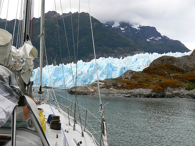
Viewing the glacier by boat at Parque Nacional Laguna San Rafael. Photo © Ralf Peek, licensed Creative Commons Attribution.
For a place so thinly populated and rarely visited, Laguna San Rafael has an intriguing history. Its first European visitor was Spaniard Bartolomé Díaz Gallardo, who crossed the low-lying Istmo de Ofqui (Isthmus of Ofqui) from the Golfo de Penas. Jesuit missionaries visited in 1766 and 1767, bestowing its present name, but the Spanish king soon expelled them from the continent.
British naval officer John Byron, grandfather of the poet Lord Byron, once spent a winter marooned here. During the voyage of the Beagle, Darwin made extensive observations, while Chilean naval officer Enrique Simpson delivered the first official report in 1871. In 1940, the government began a canal across the isthmus to simplify communications with the far south but soon gave up the project. In 1959, it declared the area a national park, but as late as the 1980s it entertained proposals to build a road for cargo transshipments.
Laguna San Rafael is 225 kilometers southwest of Puerto Chacabuco via a series of narrow channels, but only 190 kilometers from Coyhaique as the air taxi flies. To the east rises the rugged Patagonian mainland; to the west lie the myriad islands of the Archipiélago de Chonos and the Península de Taitao.
Altitudes range from sea level to 4,058-meter Monte San Valentín, the southern Andes’s highest peak. Sea-level temperatures are fairly mild, about 8°C, with upwards of 2,500 millimeters of rainfall per year. At higher elevations, precipitation doubles, temperatures are colder, and the snowfall feeds 19 major glaciers that form the 300,000-hectare Campo de Hielo Norte. Pacific storms can darken the skies for weeks on end, but views are stunning when the overcast lifts.
In areas not covered by ice, up to about 700 meters, mixed Valdivian forest grows so dense that, wrote Darwin, “our faces, hands and shin-bones all bore witness to the maltreatment we received, in attempting to penetrate their forbidding recesses.” The main trees are two species of the southern beech coigüe, the coniferous mañío macho (Podocarpus nubigena), tepu, and other species, with an understory of shrubs, ferns, mosses, and vines. Above 700 meters, there is almost equally dense forest of the southern beeches lenga and ñire, with occasional specimens of the coniferous Guaiteca cypress.
Most of the easily visible wildlife congregates around the shoreline, beginning with eye-catching seabirds, such as the flightless steamer duck and Magellanic penguin, blackbrowed and sooty albatrosses, and various gulls. Marine mammals include the southern elephant seal, southern sea lion, and southern sea otter.
Forest-dwelling animals are harder to see, but pudu and huemul graze the uplands, while foxes and pumas prowl for prey.
Calving off the face of Ventisquero San Rafael, indigo icebergs bob and drift in the waters of Laguna San Rafael, an oval body of water measuring 6-9 kilometers in width and connected to the southern canals by the narrow Río Témpanos. The world’s lowest-latitude tidewater glacier, Ventisquero San Rafael may not be so much longer. In continuous retreat since 1960, it could be a casualty of global warming.
Relatively few visitors set foot in the park, as most arrive by ferry or catamaran, transferring to inflatables to meander among the bergs and approach the glacier’s face. Those who manage to land can hike through seven kilometers of evergreen forest on the Sendero al Ventisquero to a glacial overlook.
Excerpted from the Fourth Edition of Moon Patagonia.