It is commonly called El Yunque rainforest, but the official name of this spectacular natural preserve is the Caribbean National Forest. The name El Yunque technically refers to the forest’s second-highest peak (3,469 ft.), and it’s also the name of the forest’s recreational area. But regardless of its moniker, it is without a doubt Puerto Rico’s crowning jewel of natural treasures.
Although it’s possible to do a quick drive-by tour of El Yunque, the only way to fully appreciate its beauty and majesty is to park the car and hike into the jungle.The only tropical forest in the U.S. National Forest System—not to mention the smallest and most ecologically diverse—the Caribbean National Forest is a must-see for visitors to Puerto Rico. Nearly half of the 28,000-acre area contains some of the only virgin forest remaining on the island, which was completely covered in forest when Columbus arrived in 1493. It also contains one of the world’s most accessible rainforests.
![El Yunque National Forest, Puerto Rico. Photo © Geoff Gallice from Gainesville, FL, USA (El YunqueUploaded by pixeltoo) [<a href="http://creativecommons.org/licenses/by/2.0">CC BY 2.0</a>], <a href="https://commons.wikimedia.org/wiki/File%3AEl_Yunque_National_Forest%2C_Puerto_Rico_by_Geoff_Gallice_-_001.jpg">via Wikimedia Commons</a>.](https://www.holidaytravel.cc/Article/UploadFiles/201602/2016021614492788.jpg)
El Yunque National Forest, Puerto Rico. Photo © Geoff Gallice from Gainesville, FL, USA (El YunqueUploaded by pixeltoo) [CC BY 2.0], via Wikimedia Commons.
El Yunque is about 35 minutes east of San Juan off Carretera 3. Go south on Carretera 191 and it will take you into the forest and to El Portal Tropical Forest Center.
Trails
Although it’s possible to do a quick drive-by tour of El Yunque, the only way to fully appreciate its beauty and majesty is to park the car and hike into the jungle. It doesn’t take more than a couple of dozen steps to become completely enveloped by the dense lush foliage. One of the greatest joys of hiking in El Yunque is the sound. Here the aural assault of the 21st century is replaced by a palpable hush and the comforting, sensual, eternal sounds of water dripping, gurgling, rushing, raining. It’s more restorative than a dozen trips to the spa.
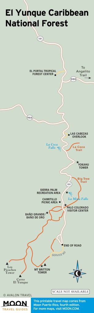
El Yunque Caribbean National Forest
There are 12 trails spanning about 14 miles in El Yunque. Many of the trails are paved or covered in gravel because the constant rain and erosive soil would require continuous maintenance to keep them passable. Nonetheless, hiking boots with good tread are a necessity. Even paved trails can be slippery and muddy. The warm air and high humidity also require frequent hydration, so bring plenty of water. And naturally, it rains a lot, so light rain gear is recommended. Avoid streams during heavy rains as flash floods can occur. Primitive camping is permitted in some areas. Permits are required and can be obtained at El Portal Tropical Forest Center.
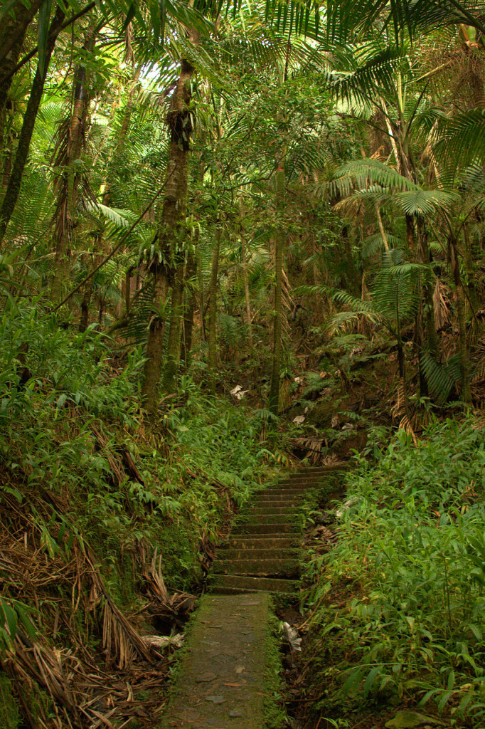
Footpaths at El Yunque National Forest. Photo © drbeachvacation, via Wikimedia Commons.
The following trails are found in El Yunque Recreation Area. All trail lengths and hiking times are approximate.
- Angelito Trail (0.5 mile, 15 minutes, easy, clay and gravel) crosses a stream and leads to Las Damas, a natural pool in the Mameyes River. To get to the trailhead, proceed south on Carretera 191 just past El Portal and turn left on Carretera 988, 0.25 mile past Puente Roto Bridge.
- La Coca Trail (2 miles, 1 hour, moderate to strenuous, gravel) starts at La Coca Falls and requires navigating over rocks to cross a couple of streams.
- La Mina Trail (0.5 mile, 25 minutes, moderate, paved and steps) starts at Palo Colorado and follows the La Mina River, ending at La Mina waterfall, where it connects with Big Tree Trail.
- Big Tree Trail (1 mile, 35 minutes, moderate, paved and steps) is an interpretive trail with signs in Spanish and English. It passes through tabonuco forest, over streams, and ends at La Mina waterfall, where it connects to La Mina Trail. The trailhead is by a small parking area at Carretera 191, kilometer 10.2.
- Caimitillo Trail (0.5 mile, 25 minutes, easy, paved and steps) begins at Sierra Palm Recreation Area and crosses a stream. Along the way you’ll pass a picnic area and structures used by the Puerto Rican parrot recovery program. It connects to the Palo Colorado Visitors Center and El Yunque Trail.
- Baño de Oro Trail (0.25 mile, 20 minutes, moderate, paved and gravel) starts just south of the Palo Colorado Visitors Center and passes by Baño de Oro before connecting with El Yunque Trail.
- El Yunque Trail (2.5 miles, 1 hour, strenuous, paved and gravel) is one of the forest’s longest and most strenuous hikes. It starts a little north of the Palo Colorado Visitors Center and climbs to an altitude of 3,400 feet. Along the way it passes several rain shelters, through the cloud forest, and ends at the peak of El Yunque. The lower part of the trail is accessible from Caimitillo Trail and Baño de Oro Trail. The higher reaches of the trail connect with Mount Britton Trail and Los Picachos Tower Trail.
- Mount Britton Trail (1 mile, 45 minutes, strenuous, paved) starts at Carretera 9938, a loop road at the end of Carretera 191. It is an uphill hike through tabonuco, sierra palm, and cloud forests. The trail crosses two streams and runs along a service road for a short distance—if you’re not sure which way to go, just keep heading straight up. It ends at the Mount Britton Tower, built in the 1930s by the Civilian Conservation Corps.
- Mount Britton Spur (1 mile, 30 minutes, moderate, paved) connects Mount Britton Trail to El Yunque Trail.
- Los Picachos Trail (0.25 mile, 25 minutes, strenuous, unpaved and steps) is a steep ascent from El Yunque Trail to an observation deck built by the CCC.
The forest’s remaining two trails are outside El Yunque Recreation Center on the western side of the forest. The trails are unpaved, muddy, not maintained, and often overgrown in parts. Long sleeves and pants are recommended for protection against brush, some of which can cause skin irritation on contact. These trails are for adventurous hikers who really want to get away from it all.
- Trade Winds Trail (4 miles, 4 hours, strenuous, primitive) is the forest’s longest trail. To reach the trailhead, drive all the way through El Yunque Recreation Area to the end of Carretera 191 where the road is closed. Be mindful not to block the gate. Walk past the gate 0.25 mile to the trailhead. The trail ascends to the peak of El Toro, the highest peak in the forest, where it connects with the El Toro Trail.
- El Toro Trail (2 miles, 3 hours, difficult, primitive) starts at Carretera 186, kilometer 10.6, and traverses tabonuco, sierra palm, and cloud forests. It connects with the Trade Winds Trail.
Excerpted from the Fourth Edition of Moon Puerto Rico.