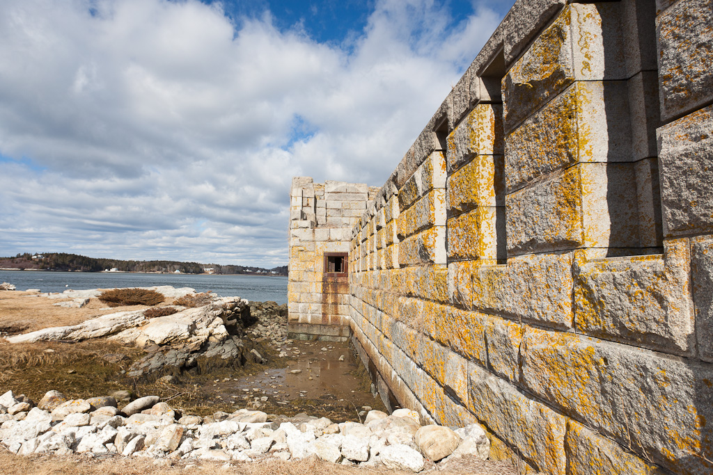
Fort Popham State Historic Site. Photo © Roger H. Goun, licensed Creative Commons Attribution.
Thanks to a map and brochures produced by the Phippsburg Business Association and Phippsburg Land Trust and an online guide from the Phippsburg Historical Society, it’s easy to spend the better part of a day or longer exploring the peninsula that extends south from Bath.About two miles south of Bath is a causeway known as Winnegance, a Wabanaki name usually translated as “short carry” or “little portage.” Native Americans crossed here from the Kennebec River to the New Meadows River.
Youngsters love [Fort Popham]—they can fish from the rocks, explore the 1865 stone fortress, picnic on the seven-acre grounds, and create sand castles on the tiny beach next to the fort.It’s another 1.3 miles to the Dromore Burying Ground (on the right), with headstones dating from 1743. The next mile opens up with terrific easterly views of Dromore Bay. Right in the line of sight is state-owned, 117-acre Lee Island, which is off-limits May through mid-July to protect nesting eagles and waterfowl.Next you’re in Phippsburg Center, alive with shipbuilding from colonial days until the early 20th century. Hang a left onto Parker Head Road. After the Phippsburg Historical Museum (2pm-4pm Mon.-Fri. summer), in an 1859 schoolhouse, and the Alfred Totman Library, turn left onto Church Lane to see the “Constitution Tree,” a huge English linden planted in 1774, in front of the 1802 Phippsburg Congregational Church.
Parker Head Road continues southward and meets Route 209, which leads to Popham Beach State Park. Continue to the end of Route 209 for Fort Popham Historic Site, where parking is woefully inadequate in summer. Youngsters love this place—they can fish from the rocks, explore the 1865 stone fortress, picnic on the seven-acre grounds, and create sand castles on the tiny beach next to the fort. Resist the urge to swim, though; the current is dangerous and there’s no lifeguard. Across the river is Bay Point, a lobstering village at the tip of the Georgetown Peninsula. Percy’s Store (207/389-2010), by the way, with a handful of tables, is a good bet for pizza, picnic fare, fried dough, and fishing tackle.
Across the cove from the fort is Fort Baldwin Road, a one-lane-wide winding road leading to the shorefront site of the 1607 Popham Colony. Climb the path up Sabino Hill to what’s left of World War I-era Fort Baldwin, the best vantage point for panoramic photos.
Backtrack about four miles on Route 209, turn left onto Route 216, and head toward Small Point. Go about 0.9 mile to Morse Mountain Road, on the left, which leads to the parking area and trailhead for the Bates-Morse Mountain Preserve. Farther south are Head Beach and Hermit Island.
Returning northward on Route 216, you’ll hook up with Route 209 and then see a left turn (Rte. 217) to Sebasco Harbor Resort. Take the time to go beyond the resort area. When the paved road goes left (to the Water’s Edge Restaurant), turn right at a tiny cemetery and continue northward on the Old Meadowbrook Road, which meanders for about four miles along the west side of the peninsula. About midway along is The Basin, regarded by sailors as one of the Maine coast’s best “hurricane holes” (refuges in high winds). As you skirt The Basin and come to a fork, bear right to return to Route 209; turn left and return northward to Bath.
Excerpted from the Fifth Edition of Moon Coastal Maine.