Mount Robson
TIME : 2016/2/22 10:07:40
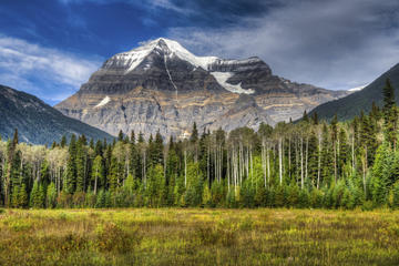
Mount Robson
At 12,972 ft (3,954 m), Mount Robson is the highest peak in the Canadian Rockies and the second highest peak in British Columbia; its south face is visible from the Yellowhead Highway and is a popular photographic subject along this route. Mount Robson is also known as Cloud Cap Mountain and The Mountain of the Spiral Road because of its distinctive, horizontal layers of rock which angle upwards to the east, giving the appearance of a track running around the mountain to form a spiral. The 4,921 ft (1,500 m) Emperor Face on the northwest side is the most difficult route for climbers, though the most popular routes are the Kain route and the southeast face. Although the mountain is less than 13,200 ft (4,000 m), there is no easy way to summit and Mount Robson has small success rate: about 10% of summit attempts are successful.
Mount Robson Provincial Park, where Mount Robson is located, is the second oldest park in British Columbia’s park system, celebrating its 100th birthday in 2013. Set to the west of Jasper National Park, Mount Robson Provincial Park is part of the Canadian Rocky Mountains World Heritage Site, a UNESCO World Heritage site. The park consists of more than 536 acres undisturbed wilderness, home to 182 species of birds and many Rocky Mountain mammals such as deer, moose, caribou, mountain goats and sheep, bears and elk.
Practical Info
Mount Robson is located in the Fraser River Valley east of the Robson River about 2.5 mi (4 km) south of Berg Lake. Entrance to the park is free; camping rates vary. During the operating season, park gates open at 7 a.m. and close at 11 p.m. unless otherwise noted.