The 12,016-hectare (29,692-acre) Parque Nacional Volcán Arenal (tel. 506/8775-2943 or 506/2461-8499, 8am-4pm daily, last entrance at 3pm except with local guide, $10) lies within the 204,000-hectare (500,000-acre) Arenal Conservation Area, a polyglot assemblage protecting 16 reserves in the region between the Guanacaste and Tilarán mountain ranges, and including Laguna de Arenal. The park has two volcanoes: extinct Chato (1,140 meters/3,740 feet), whose collapsed crater contains an emerald lagoon, and active Arenal (1,633 meters/5,358 feet), a picture-perfect cone.
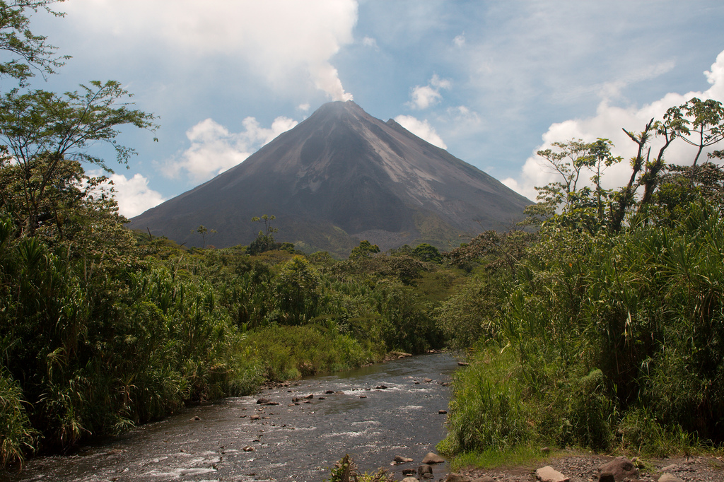
Arenal Volcano, Costa Rica’s most active volcano.
Photo by Christian Haugen licensed Creative Commons Attribution.
Hiking too close to the volcano is not advisable. Heed the warning signs—the volcano is totally unpredictable, and there is a strong possibility of losing your life if you venture into restricted zones.
Arenal slumbered peacefully throughout the colonial era. On July 29, 1968, it was awakened from its long sleep with a fateful earthquake. The massive explosion that resulted wiped out the villages of Tabacón and Pueblo Nuevo. The blast was felt as far away as Boulder, Colorado. Thereafter its lava flows and eruptions were relatively constant, and on virtually any day you could see smoking cinder blocks tumbling down the steep slope from the horseshoe-shaped crater—or at night, watch a fiery cascade of lava spewing from the 140-meter-deep (460-foot-deep) crater. Some days the volcano blew several times in an hour, spewing house-size rocks, sulfur dioxide, chloride gases, and red-hot lava. The volcano’s active vent often shifts location; for the past decade it has been on the northern side, but in 2008 a collapse at the crater rim shifted the predominant lava flows to the southern side. Explosions and eruptions, however, occur on all sides.
The volcano entered a particularly active phase in 2005, with an average of five to eight “big boom” explosions daily. In September 2010 it suddenly went quiet, but since 2013 has been intermittently active.
The one-kilometer (0.6-mile) Las Heliconias Trail leads from the ranger station past an area where vegetation is recolonizing the 1968 lava flow. The trail intersects the Look-Out Point Trail, which leads 1.3 kilometers (0.8 miles) from the ranger station to a mirador—a viewing area—from which you can watch active lava flowing. Las Coladas Trail begins at the intersection and leads 2.8 kilometers (1.7 miles) to a lava flow from 1993. The Los Miradores Trail begins at park headquarters and leads 1.2 kilometers (0.75 miles) to Laguna de Arenal.
Reserva Privada El Silencio (tel. 506/2479-9900, 7am-9pm daily, $5), 500 meters (0.3 miles) east of the turnoff for the national park, has a three-kilometer (2-mile) trail. You can even drive up to a lookout beneath the flow. The closest hiking to the lava flows (and the only one offering hikes on the big lava flows), is at nearby Arenal 1968 (tel. 506/2462-1212, 8am-7pm daily, $15), near the entrance to Parque Nacional Volcán Arenal. Oropendolas and parrots inhabit the guayaba trees festooned with epiphytes in the parking lot, near a mirador that offers sweeping vistas. A steep trail leads up the four-decade-old lava flow. It’s a fabulous hike! The full loop trail takes you past a grotto that is a shrine to those who died in 1968. The 4.5-kilometer (3-mile) Forest Hike leads through a wooded area ringing a small lake created by the 1968 eruption. It also has mountain bike and horse trails.
You can also hike at the Arenal Observatory Lodge (tel. 506/2479-1070). A guided hike is offered at 8:30am daily (complimentary to guests). The four-kilometer (2.5-mile) Lava Trail (a tough climb back to the lodge—don’t believe your guide if they say it’s easy) is free and takes about three hours round-trip. The Chato Trail (4 hours) is longer and more difficult. The Arenal Observatory Lodge has a small but interesting Museum of Volcanology. Outside the entrance to the lodge is the trailhead for the private www.originalarenalatv.com (self-guided, 8am-8pm daily, $4), which leads to the southernmost lava flows (1 hour one-way). Arenal ATV (tel. 506/2479-8643), opposite the park entrance gate, has ATV tours ($89) at 7:30am, 11:30am, and 2:30pm daily.
No camping is allowed in the park. However, you can camp on land adjacent to the ranger station ($2.50 pp), with basic toilets and showers.
The turnoff to the park entrance is 2.5 kilometers (1.5 miles) west of Tabacón and 3.5 kilometers (2 miles) east of the Laguna de Arenal dam. The dirt access road leads 1.5 kilometers (0.9 miles) to the ranger station, which gives a small informational pamphlet and has restrooms. A dirt road leads north from here 1.5 kilometers (0.9 miles) to a parking lot and hiking trails.
Excerpted from the Tenth Edition of Moon Costa Rica.