Guatemala has more than 90 protected areas encompassing about 28 percent of the country’s total land area. Among the different types of protected areas are biosphere reserves, national parks, biotopes, natural monuments, wildlife refuges, and private nature reserves. Several of these are encompassed within larger areas, as is the case with the national parks and biotopes making up the larger Maya Biosphere Reserve. Most of Guatemala’s protected areas, including the biosphere reserves, have been created since 1990. All of Guatemala’s volcanoes are protected areas. There are also laws in effect to protect endangered wildlife species; among these are Guatemala’s big cats and parrots.
Sierra del Lacandón National Park is a densely forested, rugged mountain park said to harbor one of the largest populations of jaguars in all of Central America.The National Protected Areas Council (CONAP) is the entity charged with administering Guatemala’s protected areas. It was created in 1990, along with the National Environmental Commission (CONAMA), which oversees broader environmental matters and was replaced in 2000 by the Ministry of the Environment and Natural Resources (MARN). CONAP has been historically underfunded and understaffed, leaving few resources with which to protect vast areas of land from invasion. Private conservation groups have stepped in to assist CONAP in its mandate, and there are now several parks coadministered or primarily administered by private organizations. A specially trained police force began operating in Guatemala’s protected areas in 2005, particularly in the Maya Biosphere Reserve, aided by M-16s and AK-47s to combat well-armed timber and wildlife poachers. All the parks have at least rudimentary ranger stations. In an ongoing effort to attract more park visitation, many have excellent facilities for guest accommodations and well-marked trails.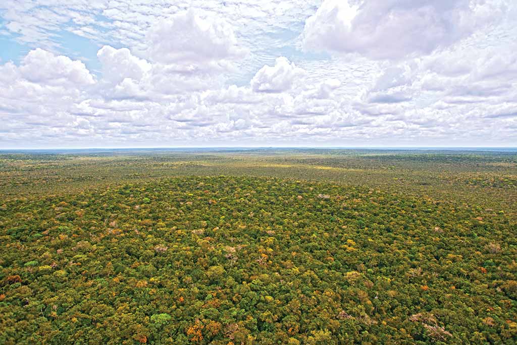
Guatemala’s impressive Maya Biosphere Reserve. Photo © Al Argueta.
Privately managed by conservation group Defensores de la Naturaleza, Sierra de las Minas Biosphere Reserve is a vast, 236,000-hectare mountain park encompassing a diverse variety of ecosystems, including cloud forests harboring several species of endemic conifers, as well as tropical moist and rainforests. The peaks of Sierra de las Minas surpass 3,000 meters (9,800 feet) in elevation and are home to healthy populations of quetzals and jaguars, among other exotic animals. Sixty-two permanent streams have their source in the upper slopes of the biosphere reserve, making it an important watershed supplying the Motagua and Polochic Rivers. Together with the adjacent Bocas del Polochic Wildlife Refuge, the parks account for 80 percent of Guatemala’s biodiversity.
The 1.6-million-hectare Maya Biosphere Reserve is composed of Tikal National Park, Laguna del Tigre National Park, Mirador-Dos Lagunas-Rio Azul National Park, Sierra del Lacandón National Park, Biotopo El Zotz-San Miguel La Palotada, Yaxhá-Nakum-Naranjo Natural Monument, and multiple-use and buffer zones. This large swath of land encompasses roughly a third of the Petén department and is Guatemala’s last hope for preserving a sizable part of the Petén forests. Contiguous with large parks in neighboring Mexico and Belize, it is part of the largest protected tropical forest in Mesoamerica.
The various parks are protected, on paper at least, from all human activity, though a sizable multiple-use zone exists in large areas of the park, permitting sustainable extraction of forest products such as xate palm and chicle, oil drilling (present before the park’s creation), and community forestry concessions. Standing between the core zones and the deforestation characterizing much of the rest of Petén is an ever-shrinking buffer zone increasingly porous to the advance of the agricultural frontier.
Potential travelers to Guatemala’s Maya Biosphere Reserve are urged to contact one of the conservation groups managing the individual parks before planning a visit, so as to ascertain current safety conditions. As conservationists and archaeologists working in the field can attest, there are too many illegal activities perpetrated by heavily armed men, and far too many stories of run-ins with them, to be out running around in these parts oblivious to the potential dangers. That said, some well-established parks such as Tikal and Yaxhá can be considered generally safe, along with some well-established ecotourism circuits in the Maya Biosphere Reserve, including the Scarlet Macaw Trail, trips to El Zotz-San Miguel La Palotada, and treks to El Mirador.
Tikal National Park, the oldest and best known of Guatemala’s national parks, was created in 1956 and declared a UNESCO World Heritage Site in 1979. It encompasses 357 square kilometers of primary tropical forest and protects a vast array of wildlife, as well as harboring the remains of one of the Mayan civilization’s greatest cities. Tikal is understandably high on the list of priorities for any visitor to Guatemala and shouldn’t be missed.
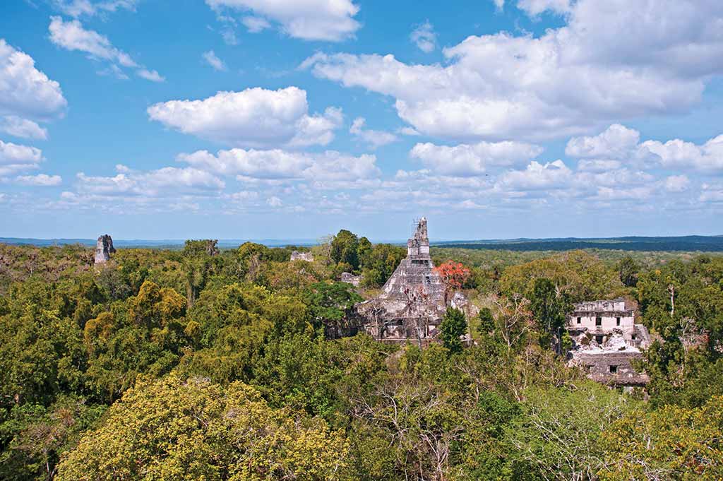
View of Tikal from Temple V. Photo © Al Argueta.
Laguna del Tigre National Park is a vast park on the northwestern corner of Petén encompassing important wetlands, the largest in Central America. It also contains the only remaining populations of scarlet macaws in Guatemala, which are being protected via ongoing conservation efforts at a biological research station. Oil drilling, present before the park’s creation, continues inside the reserve, despite protests from environmental groups and its having been declared a violation of the park’s intended use. Also going on inside the park are the clandestine activities of loggers, wildlife poachers, drug traffickers, and smugglers of illegal immigrants across the border to Mexico. Archaeologists working in these parts enter under the escort of heavily armed guards. Visitors to this park should limit their activities to those centered around the Scarlet Macaw Biological Research Station, as the current lawless conditions prevent my recommending more in-depth explorations of this wild frontier.
Sierra del Lacandón National Park is a densely forested, rugged mountain park said to harbor one of the largest populations of jaguars in all of Central America as well as an incredible degree of biodiversity. Hidden in the forests are the remains of several Mayan sites, the most important of which is Piedras Negras, deep inside the park along the Usumacinta River, which marks the western border with Mexico. The park is privately administered by Fundación Defensores de la Naturaleza. In June 2006, together with The Nature Conservancy, it completed the purchase of 31,000 hectares (77,000 acres) of privately owned land in the core zone of Sierra del Lacandón. There are a number of ranger stations inside the park, the most prominent of which is at Piedras Negras.
A large park in the northern section of the Maya Biosphere Reserve near the Mexican border, Mirador-Dos Lagunas-Río Azul National Park protects vast expanses of tropical forests and the remains of several Mayan cities. Among the most impressive ruins are those at El Mirador, including El Tigre temple, which is 18 stories high with a base the size of three football fields. Other sites inside the park include Río Azul and Nakbé, visible from the top of El Mirador’s massive temples. Access to the park is by foot, a full day’s walk from the village of Carmelita, or helicopter.
Laguna Lachuá National Park consists of a circular lagoon in the Ixcán jungle west of Cobán surrounded by 14,500 hectares of tropical forest and several miles of hiking trails. The karst limestone nature of this placid pool makes it a very attractive turquoise. A high concentration of mahogany trees in the surrounding forests has made it vulnerable to clandestine logging.
One of Guatemala’s oldest protected areas encompassing the watershed of its namesake river connecting Lake Izabal with the Caribbean Sea, Río Dulce National Park covers 7,200 hectares along its 30-kilometer-long course. In many places, the banks of the river are shrouded in dense tropical forest punctuated at one point by a large canyon with high rock faces.
Excerpted from the Fifth Edition of Moon Guatemala.