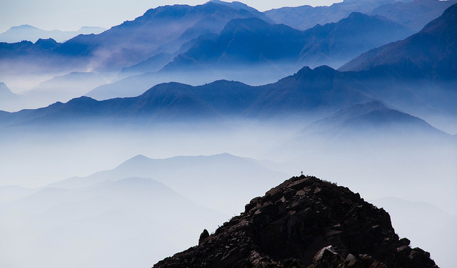
A dramatic view at Parque Nacional La Campana. Photo © Daniel Diaz Vera, licensed Creative Commons Attribution.
Rising above the fertile coastal plain of Quillota, La Campana comprises 8,000 hectares of sheer-sided scrubland, scattered “oak” forests, and the greatest remaining concentration of the rare Chilean palm. A UNESCO World Biosphere Reserve since 1984, the former Jesuit hacienda of San Isidro is the place where temperate southern Chile’s forests reach their northernmost, overlapping the Norte Chico’s desert scrub.Noteworthy for a network of integrated hiking trails that cross ridges and scale summits with spectacular views from the Pacific to the summit of Aconcagua (across the border in Argentina), it is also a historic site. Trekking toward the Andes from Valparaíso in the winter of 1834, Charles Darwin detoured to climb the summit of Cerro La Campana, an experience that he detailed in The Voyage of the Beagle:
The evening was fine, and the atmosphere so clear, that the masts of the vessels at anchor in the bay of Valparaíso, although no less than twenty-six geographical miles distant, could be distinguished clearly as little black streaks. A ship doubling the point under sail, appeared as a bright white speck….
The setting of the sun was glorious; the valleys being black, whilst the snowy peaks of the Andes yet retained a ruby tint….
We spent the day on the summit, and I never enjoyed one more thoroughly. Chile, bounded by the Andes and the Pacific, was seen as in a map. The pleasure from the scenery, in itself beautiful, was heightened by the many reflections which arose from the mere view of the Campana range with its lesser parallel ones, and of the broad valley of Quillota directly intersecting them….
In the coastal range east of Viña del Mar, La Campana consists of three sectors: the adjacent Sector Granizo and Sector Cajón Grande are about 45 kilometers east of Viña del Mar via Ruta 62 through Villa Alemana, Limache, and Olmué; Sector Ocoa is about 110 kilometers northwest of Santiago via the Panamericana. Elevations range from about 400 meters near the park entrances to 2,222 meters on Cerro El Roble, the park’s highest summit. The rugged topography can be challenging even for very strong hikers. Like coastal Southern California, La Campana enjoys a mild Mediterranean climate, cooled by the maritime influences of the Pacific. While the annual precipitation is only about 800 millimeters, it nearly all falls between May and September; the dry summer and autumn are fire season. Winter can bring snowfall to the summits, but even in summer a sweater or light jacket is a good idea at upper elevations.
La Campana has more than 300 different plant species forming several different associations. In the relatively well-watered ravines, between about 300 and 1,000 meters above sea level, there are gallery forests of species such as patagua, lingue, and belloto. On south-facing slopes, up to about 1,000 meters, sclerophyllous forests of peumo, boldo, and quillay tolerate the annual summer drought.
At higher altitudes, above 800 meters, deciduous forests of roble de Santiago (Nothofagus obliqua, referred to by Chileans as an “oak”) constitute the most northerly species of this “false beech” genus. There are also communities of Chilean palm (Jubaea chilensis), punctuated with occasional cacti, and open thorn forests of acacia and smaller shrubs. In addition, on north-facing slopes, shrub communities known as matorrales resemble California’s chaparral, relying on natural fires to renew themselves at regular intervals. Above 1,500 meters, similar but more widely spaced communities occupy thin soils. Clusters of cacti also punctuate the landscape.
Guanacos once roamed the park, but today’s fauna are smaller and less conspicuous—foxes, viscachas, skunks, and tinier rodents, along with more than 50 species of birds, most notably quail, pheasant, owls, and hummingbirds.
Most of the sights are accessible by trails that crisscross the park or loop through it. Near the Granizo entrance, the Sendero La Canasta provides a good introduction to the forest, looping past several labeled trees and shrubs in the course of half an hour’s walk (the identifications on this nature trail, though, do not place the information in an ecological context).
More gratifying, if more strenuous, is the seven-kilometer Sendero Andinista, from the Granizo entrance to the 1,880-meter summit of Cerro La Campana, where hikers enjoy the same views that entranced Darwin. While the distance may not seem great and the climb is not technical, the 1,507-meter elevation gain means an average grade of almost 22 percent. For most people, it’s a full-day excursion, more tiring than Patagonia’s famous Torres del Paine. The hard-baked trail can be slippery even when dry, so wear suitable shoes.
Fortunately, most of the hike passes through shady forest and three cool springs with potable water: Primera Aguada, 580 meters above sea level, about an hour along the trail; Segunda Aguada, around the midway point, where camping is possible; and La Mina, the drive-in campground at the abandoned mine site, where the trail continues to the summit (in dry weather, with a high-clearance vehicle, it’s possible to reach La Mina by road).
Beyond the mine site, the trail becomes narrower and steeper; here, 1,500 meters above sea level, the Sociedad Científica de Valparaíso and the city’s British community placed a commemorative plaque on the 101st anniversary of Darwin’s ascent (which he reached August 17, 1834, having camped below the summit on the previous day). Another plaque, dedicated by the Club Montañés de Valparaíso, remembers climbers who died when an earthquake triggered a landslide in 1868.
Sector Ocoa, at La Campana’s northern approach, is its largest sector, about 5,440 hectares. From Casino, two kilometers beyond the entrance station, the Sendero El Amasijo climbs gradually up the Estero Rabuco’s palmfilled gorge to the Portezuelo de Granizo saddle, where it bifurcates: The southern Sendero Los Robles descends to Sector Cajón Grande, while the Sendero Los Peumos heads west to Sector Granizo. Either route is a feasible day trip, but it’s also possible to camp in Estero Rabuco. Carry plenty of water since livestock have made the streams unpotable, except for a spring just below the Portezuelo de Granizo.
Also at Sector Ocoa, the Sendero La Cascada is a four-hour round-trip to an attractive waterfall. There are other shorter trails in the area.
Within the park, camping is the only option. Organized camping for up to six people costs US$12 at Conaf’s Sector Granizo (tel. 033/443067, 23 sites), Sector Cajón Grande (22 sites), and Sector Ocoa (16 sites). Backcountry camping is possible, but in areas that are steep, rocky, or fire-prone; Conaf permission is required.
Half a block off Olmué’s Plaza de Armas, Hostería Copihue (Diego Portales 2203, tel. 033/441544, US$90–110 s, US$140–175 d with breakfast) is a sprawling 40-suite resort with pool, tennis courts, and other amenities. Its main clientele is Chilean families but, given its access to Las Campanas, it also gets foreigners who go hiking in the park. Half-board and full-board packages are also available. For fairly conventional Chilean cuisine, the quality is well above average. Major discounts are possible for the off-season.
Also in Olmué, long known for its Chilean country cooking, Parador de Betty (Av. Eastman 4801, tel. 033/441511, US$40 pp with breakfast) has recently expanded into accommodations. The kitchen produces specialties such as pastel de choclo (meat-filled casserole with a crust of sweet corn), humitas (steamed tamales), cazuelas (stews) and the like at a high level. The last weekend in March, it hosts the annual Festival de la Comida del Huaso to showcase the best of rural food and other products, to the accompaniment of folkloric music and dance.
At each park entrance, Conaf rangers collect a US$4 admission fee for Chileans and Chilean residents; children pay half. Foreign visitors pay US$5 (US$3 for kids).
The Granizo ranger station occasionally has maps, for a small charge, and usually has books on flora, fauna, and other conservation topics. Visitors specifically interested in flora can buy Rodrigo Villaseñor Castro’s inexpensive (Spanish-only) Guía para el Reconocimiento de las Especies Arbóreas y Arbustivas en el Parque Nacional La Campana (1998), a joint publication of Conaf and Valparaíso’s Universidad de Playa Ancha.
La Campana is readily accessible from Valparaíso and Viña del Mar, less so from Santiago. From Valparaíso’s Estación Puerto, Merval trains take an hour to reach Limache, where taxi colectivos shuttle back and forth to Olmué and the Granizo entrance.
From Santiago, any northbound bus along the Panamericana can drop passengers at Hijuelas, where an ill-marked gravel road heads south just before the main highway bridge over the Río Aconcagua. There is no regular public transportation on this road, which is 12 kilometers from the Ocoa entrance.
Excerpted from the Fourth Edition of Moon Chile.