The hike up to the sulfurous Laguna Verde (3,800 meters/12,500 feet), a dazzling, emerald green crater lake on the north side of the dormant Volcán Azufral, is easy to make from Pasto. Laguna Negra is a smaller neighboring lake. A sacred site for the Pasto indigenous people, the volcano is part of the Nudo de los Pastos mountain range, which serves as a natural border between Colombia and Ecuador. The vegetation in the páramo (highland moor) is sparse, with low shrubs, wildflowers, moss, and lichen. There is little fauna to be seen, except for the occasional gavilan (vulture) gliding through the air. From here on a clear day you can see as far as the Galeras volcano in Pasto.
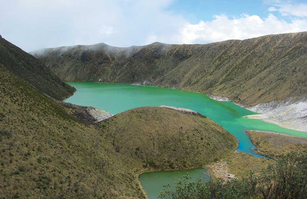
View from the path to Laguna Verde. Photo © Andrew Dier.
A sacred site for the Pasto indigenous people, the volcano is part of the Nudo de los Pastos mountain range.The Nudo de los Pastos is where the great Andes mountain range coming north from Ecuador splits into two ranges in Colombia: the Cordillera Central (Central Mountain Range) and the Cordillera Occidental (Western Mountain Range). The Cordillera Central continues northwards through Pasto, Cali, much of the Coffee Region, Medellín, and eventually into the Bolívar department (province) near the Caribbean. The Cordillera Occidental rises between the Pacific Ocean and the Río Cauca and continues through the departments of Chocó and Antioquia to the Gulf of Urabá on the Caribbean coast.The Reserva Natural Azufral is managed by a community organization, the Asociación Azufral los Andariegos Túquerres (Cra. 6A No. 16D-50, tel. 2/730-8955, cell tel. 316/713-3823). From the park ranger’s cabin, it is a six-kilometer hike to Laguna Verde and Laguna Negra. Hikers are requested to register at the cabin and pay a small entry fee (COP$2,000). It is an easy, gradual ascent as it follows a dirt road all the way up the mountain. This can take 3-5 hours. It is hard to get lost, especially on weekends and holidays when there are many fellow hikers.veg
Weather can change on a dime, temperatures can dramatically drop, and the winds can be fierce. Wear warm clothing, bring along a waterproof windbreaker and drinking water, and pick up some fruit from the Túquerres market to keep you going. Economical breakfasts, lunches, and a hot agua de panela (hot drink made from raw brown sugar) or tinto (black coffee) can be had at the ranger’s cabin. Call in advance (cell tel. 316/713-3823) to arrange for meals. The best time to make the trek is July-October or January-April when the weather is drier.
Túquerres, the nearest town to the hike’s starting point, is not beautiful, but if you make the hike on a Thursday, be sure to catch the open-air Santamaría Market (6am-2pm). There’s the usual cornucopia of fruits and vegetables, including some really really odd-looking potatoes. Stray dogs hang out in the freshly slaughtered meat section. The call of “a mil, a mil, a mil” (“for one thousand, for one thousand”) rings across the market, as increasingly anxious vendors try to sell their vegetables (and rabbits and chickens) to a dwindling number of potential customers.
Excerpted from the First Edition of Moon Colombia.