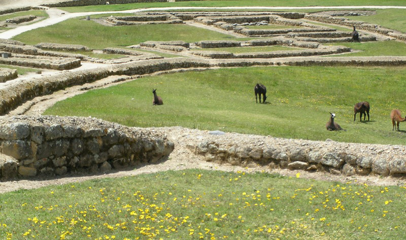
The remains of walls at Ingapirca. Photo © Julia Rubinic, licensed Creative Commons Attribution.
The sight of the Inca empire’s only remaining sun temple standing proudly on a hill at 3,200 meters elevation with panoramic views over the surrounding countryside is highly impressive. Ingapirca, which means “Inca stone wall,” is easily Ecuador’s best set of pre-Columbian ruins and well worth a day trip from Cuenca or a 10-kilometer detour off the Panamericana. However, comparisons with Machu Picchu will fall well short, and if you’re traveling up from Peru, you may find the ruins rather modest.The Cañari lived here long before the Incas arrived, erecting a Temple of the Moon, the foundations of which are still visible today. The Incas, led by Huayna Capac, arrived at the end of the 15th century and defeated the Cañari after a long, drawn-out battle. Interestingly, following their victory, the Inca had enough respect for the Cañari to build a community together, and constructed their own Temple of the Sun to complement the original temple. As well as employing their astonishing stonework, the Inca also built a complex underground irrigation network. Ingapirca was almost certainly used for ritual sacrifices because female skeletons have been unearthed on a site that was probably a convent for maidens.
Ingapirca’s position overlooking the surrounding valley was of key strategic importance, but the city’s growth was short-lived because the Spanish arrived before it was even completed. Ingapirca was ransacked and much of the stonework taken by the Spanish to build churches in Cuenca and beyond. The site lay abandoned until the Ecuadorian government began a restoration process in the mid-20th century, and the site was opened to the public in 1966. It is now run by a group of local Cañari indígenas.
Much of the site is little more than stone foundations, and it takes imagination and a guided tour to bring it to life. The famous rounded Temple of the Sun is well-preserved, however, and forms an impressive centerpiece to the complex. Surrounding it are five hectares of low stone walls and grassy slopes. The small Pilaloma complex on the south side marks the original Cañari settlement, next to a pointy-roofed replica of an Inca house and round depressions called colcas that were used to store food.
A fragment of Inca road called the Ingañan leads past bodegas used for food storage to an exterior plaza known as La Condamine, named after the French scientist’s visit in 1748. These were the nobles’ living quarters, including the acllahuasi—dwellings of ceremonial virgins where skeletons have been found.
The highlight of the complex is the Temple of the Sun, also known as El Castillo (The Castle). The mind-boggling stonework that is the hallmark of Inca construction can be appreciated in this two-story structure, hand-carved so precisely that mortar was unnecessary. Steps lead up to a trapezoidal doorway (four-sided, with two parallel sides) and a rectangular platform. It’s entertaining to stand in the sentry posts of the temple and hear your whispers reverberate around the walls. Take a few moments to appreciate the view from here—the temple’s location is as mesmerizing as its construction.
To the right of the temple there are ruins of the more sinister side of Inca culture: A V-shaped rock was supposedly used for human and animal sacrifices. Next to it is a larger stone with 28 holes that was thought to be used as a lunar calendar; the holes caught rainwater that told the date by reflecting the moon’s light differently throughout the month.
Just outside the complex is a small museum (included in the entrance fee), which houses a collection of Cañari and Inca ceramics, sculptures, tools, traditional dress, and a skeleton found at the site. An artisanal shop next door sells regional crafts; a café and public toilets are across the way.
Guides are available on-site (included in the entrance fee), but note that few speak much English. The guide is important to provide information to enable you to get the most out of your visit. Ask around for a guide who speaks more English (and give a tip) or alternately book a tour from Cuenca.
The ruins are open 8 a.m.–6 p.m. daily. Entrance costs $6 and includes a free tour; tips, as always, are appreciated.
From Cuenca, Trans-Cañar buses run direct from the main terminal terrestre at 9 a.m. and 1 p.m. daily (two hours, $2.50), returning at 1 p.m. and 4 p.m. On weekends, buses return at 1 p.m. only. Most tour companies in Cuenca offer organized excursions (from $45 pp).
If you’re traveling from the north along the Panamericana, get off the bus at Cañar, or better, El Tambo. There are buses every half hour between the two towns, you can take a taxi (from $5), or it’s a three-hour hike.
Most people just come for the day, but there are some accommodations nearby. About one kilometer before arriving at the ruins, in the village of Ingapirca, the family-run Residencial Inti Huasi (Vía a Ingapirca, tel. 7/221-5171, $6 pp) has clean but basic guest rooms with hot water and private baths, and a popular restaurant serves Ecuadorian fare from $3. Bring warm clothes as nights are cold here.
For a more upmarket stay, the refurbished Posada Ingapirca (tel. 7/221-5116 or 7/283-1120, $52 s, $73 d, breakfast included) has 22 comfortable, rustic guest rooms with private baths and hot water. Set in a restored farm building overlooking the ruins, adorned with indigenous art, lodging here is a delightful step back in time. Even if you don’t stay, it’s worth coming for lunch to warm up by the fireplace and take in the views in more comfort.
Most visitors go straight to Ingapirca and return to Cuenca, but there is enough time to stop off at this town for a closer look at the home of the local Cañari indígenas. Although they were defeated by the Inca, their culture has survived, and you can see them in this town dressed in brightly colored ponchos and white felt bowlers. They are well-known for their double-sided weavings, which are sold in town. The best time to visit is market day on Sunday morning.
Accommodations in Cañar are limited and rather run-down. Residencial Monica (Plaza Central, tel. 7/223-5486, $5–8 pp) has guest rooms with shared or private baths and hot water.
Buses leave every 20 minutes from the east side of town ($1, ask for directions) to the village of Ingapirca (not the ruins), taking almost an hour. Transportes Cañar has departures every 15 minutes to Cuenca (2 hours, $1.50) from its office on 24 de Mayo, a few blocks east of the plaza. For buses direct to the Ingapirca ruins, it’s best to walk to the Panamericana or go via El Tambo.
It may not be as famous or impressive as the trail in Peru, but keen hikers can make the most of the beautiful hilltop views in the countryside between Alausí and Cuenca on this three-day trail.
Keep in mind that you’ll be hiking at higher than 3,000 meters elevation the whole way, and that the trail follows a river, so it can get muddy — make sure you are acclimated, take it slow, and bring waterproof boots. The entire trail is not well marked, so maps are a good idea. The IGM Alausí, Juncal, and Cañar 1:50,000 maps cover the area and should put the trip within range of even weekend hikers — with a compass. Take plenty of food, water, and camping equipment, as facilities are thin on the ground. Alternately, book a guided trek with tour companies in Quito or Cuenca.
The start of the trail is at Achupallas. From Alausí, take any bus south for about 10 kilometers, then tackle a steep climb or hitch a ride to Achupallas. Alternately, a taxi from Alausí direct to Achupallas costs $7.
Leave Achupallas to the south past the elementary school, cross the Río Azuay, and reach the west bank of the Río Candrul after passing through a natural hole in the rock. From here, the trail heads clearly south between Cerro Mapahuña and Cerro Pucará. There’s a good campsite on the south side of Laguna Tres Cruces at 4,200 meters elevation, 14 kilometers and 6–7 hours from Achupallas.
Day 2 takes you southwest along Cuchilla Tres Cruces, which commands great views of the Quebrada Espíndola valley. This is the highest point along the hike (4,400 meters). Río Sansahuín and Río Espíndola join the Candrul near here. Descend into the valley to the left of the final peak, Quillo Loma. There are remains of an Inca road and foundations of an Inca bridge. There is also a trail to Laguna Culebrillas, and more ruins at Paredones. Although it would be possible to push to Ingapirca in one long second day, most hikers choose to spend the night among the graffitied ruins of Los Paredones (Big Walls), east of Laguna Culebrillas and 10 kilometers from Laguna Tres Cruces.
On day 3, head southwest from Paredones on the seven-meter-wide Inca road. After the village of San José, turn right to El Rodeo, then follow the road up to Ingapirca. It takes nearly five hours in total.
Note that there have been reports of thefts at campsites along the route. It’s best not to take any valuables along the route. You can also avoid this problem by hiring locals with mules to carry your luggage.
Excerpted from the Fifth Edition of Moon Ecuador & the Galápagos Islands.