Not even many Thais are aware of the northern city of Phayao. But tree-lined streets, antique wooden houses and an attractive lakeside setting combine to make it a destination that deserves a bit more acclaim.
The town’s inauspicious highlight is Kwan Phayao, the largest swamp in northern Thailand. Framed by low mountains, the swamp is in fact much more scenic than its designation suggests, and it is the setting for some of the most beautiful sunsets in the country. It’s also a great backdrop for dinner; Chue Chan, one of several restaurants that look out over Kwan Phayao, tends to get the most acclaim from locals. Huean Phak Jum Jai is a good place to bed down here.
Phayao lies on Thailand’s main north–south highway, and its bus and minivan station is quite busy. Because of this, if you're bound for Bangkok, it's possible to hop on one of the 40 or so buses that pass through the station from points further north. If you’re getting itchy feet, follow routes 1093 and 1155 from Phayao to Chiang Khong in Chiang Rai, a day trip that passes through some of the most dramatic mountain scenery in the country.
In recent years, the remote province of Nan has generated a buzz for its rural setting and historic temples. Yet one destination that has remained largely off the radar is Ban Bo Luang, a picturesque village located more than 100km north of the eponymous provincial capital.
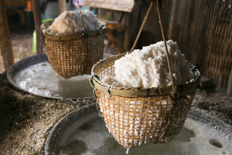
Squeezed between the Lao border and two mountainous national parks, Ban Bo Luang has long been associated with the extraction of salt from local salt wells; the village is known colloquially as Ban Bo Kleua (Salt Well Village). If you have your own transport, Ban Bo Luang is also a good base for exploring nearby natural areas. Doi Phu Kha National Park is home to the province’s highest peak as well as several hill-tribe villages, while Khun Nan National Park boasts an easy trail that culminates in a dramatic lookout over Laos.
To reach Ban Bo Luang from Nan, take a bus to Pua (50B, two hours, hourly from 7am to 5pm). Get off at the 7-Eleven and cross the highway to take the thrice-daily sŏrng·tăa·ou that terminates in the village (80B, one hour, departing at 7.30am, 9.30am and 11.30am).
In Ban Bo Luang, stay at Boklua View, where spacious and attractive hillside bungalows overlook the village and the Mang River that flows through it.
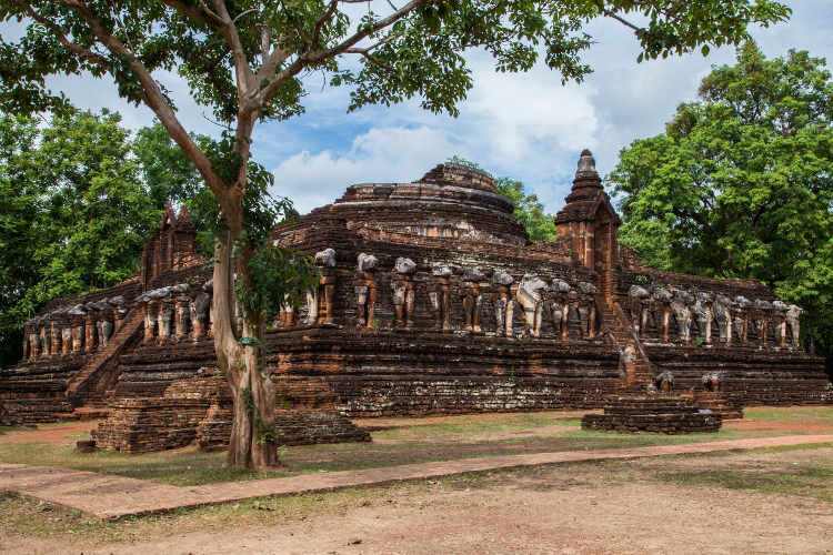
Avoid the tour buses and crowds at Sukhothai and head for the lesser-visited but nonetheless impressive 14th century ruins at Kamphaeng Phet Historical Park, a Unesco World Heritage site.
The most accessible ruins lie immediately north of the modern city and were formerly surrounded by a wall (Kamphaeng Phet means 'Diamond Gate'), while the majority of Kamphaeng Phet’s ruins are found a few kilometres outside of the city. A helpful visitor centre at the latter provides context to the more than 40 temple compounds, one of which is Wat Chang Rob, a chedi surrounded by surprisingly well-preserved elephant statues.
Kamphaeng Phet is approximately halfway between Bangkok and Chiang Mai, and most northbound buses make a stop here.
In Kamphaeng Phet, stay at the Navarat Heritage Hotel, located steps from the Ping River and the city’s busy night market. Come breakfast or lunch, consider Kamphaeng Phet’s signature dish bà·mèe (wheat-and-egg noodles in a pork broth), available at legendary local restaurant Bamee Chakangrao.
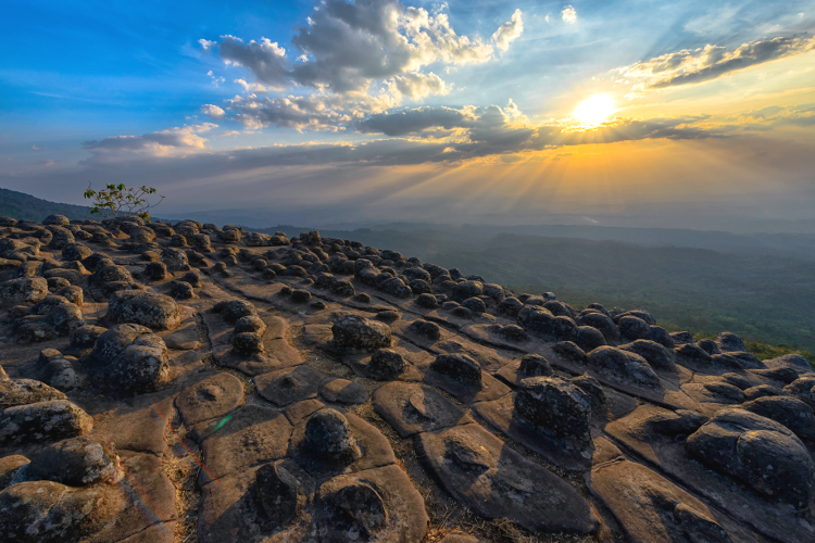
Between 1967 and 1982, Phu Hin Rong Kla, a mountain in remote Phitsanulok Province, served as the strategic headquarters for the Communist Party of Thailand (CPT) and its tactical arm, the People's Liberation Army of Thailand (PLAT). The revolution has long since been abandoned and today the area is a national park spanning 307 sq km of rugged, rocky mountains and forest. Highlights include the remains of CPT infrastructure, waterfalls, hiking trails and an abundance of interesting rock formations.
The park headquarters are about 125km from Phitsanulok. To get here, first take an early bus to Nakhon Thai (52B to 73B, two hours, every hour from 5am to 6pm). From there you can charter a sŏrng·tăa·ou to the park (700B) from near the market. Alternatively, as a day trip from Phitsanulok, agencies such as Golden House Tour charge 2500B for car and driver; petrol is extra. This is a delightful trip if you're on a motorcycle since there's not much traffic along the way, but a strong engine is necessary to conquer the hills to Phu Hin Rong Kla.
If you’re staying overnight, Thailand's Royal Forest Department can arrange accommodation, ranging from tents to comfortable bungalows.