Grand Canyon travel planner
The last leg to the North Rim of the Grand Canyon is a 44-mile drive on Arizona's State 67 that passes through forests of ponderosa pine. It runs along rolling meadows that in spring fill with shallow lakes, where herds of mule deer dissolve into the morning mists.
Beautiful as it is, this highway made me crazy some 10 years ago.
I was impatient because the North Rim represented both the end of a long day on the road and a culmination of a more profound kind. Like most Americans, I grew up with the Grand Canyon. But, long past a childhood of clicking through reels of View-Master images, I had never actually visited.
In contrast, my Canyonhead friend had made 30 trips here. He sensed a rare opportunity: Not only could he introduce me to the Grand Canyon, he could do so at the North Rim. Higher, lusher, and less crowded than the South Rim, the North Rim is the connoisseur's canyon.
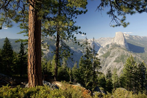
We reached a remote point, and he told me to do the unthinkable and nearly impossible: "Okay, don't look."
When I finally opened my eyes, there it was: the Grand Canyon. Sort of. I was surprised to be looking through a stand of pines out at tree-studded mesas, not the arid, red plateaus of my imaginings. I tried to take it all in, then declared, "That's not what I thought the Grand Canyon would look like."
"You got it," he said. "Welcome to the North Rim."
Though just a 10-mile cross-canyon glide from the South Rim for the local condors, the North Rim is much farther away for the rest of us: a full 215 miles by road. The North Rim is in fact closer to Zion National Park across the state line in Utah than it is to Grand Canyon park headquarters. The comparative remoteness ― and the heavy snows that limit its season to mid-May through October ― keeps the number of visitors down.
Whether you're a first-timer or have visited 100 times, the North Rim is never anything less than a revelation. And so, a decade after that first glimpse, we're back again.
Exploring the rim
No two trips are the same and this one is different even before we reach the North Rim. State 67 has been completely transformed. In the summer of 2006, the Warm Fire burned through 58,568 acres and portions of the once-dense forest are now black.
But at the Grand Canyon Lodge, the center of North Rim life, it's a mellow afternoon. Visitors rock slowly in the shade of cabin porches, while others gather in the main building's sunroom, peering out into the canyon from this soaring space of limestone walls and timbered ceilings. Beyond it, the lodge's veranda is filled with laughing hikers toasting their completion of the daunting 23-mile rim-to-rim hike, while new arrivals gaze out, too stunned by the view to say much of anything.
With the skies promising a major sunset, we head to one of the rim's best viewpoints, Cape Royal. To reach Cape Royal, you drive 23 miles, mostly out along the Walhalla Plateau, until there's no road left to drive. The view takes in an array of stone monoliths named for figures of antiquity: Apollo, Vishnu, and, most prominently, the curving rampart of Wotans Throne. Truth be told, it looks more like Wotans Settee, assuming the Norse god of war would ever settle into such an angle of repose.
The towers and temples pick up the last light through the breaking clouds, the rocks' reds deepening within the violet fog that fills the chasm. Lightning flashes along the horizon, while Wotans floats off the edge like an island and the South Rim fades into the darkness: a distant shore. It's curious that a few canyon overlooks are designated as capes rather than points. But certainly tonight Cape Royal is the ideal name for a purple place seemingly at the far edge of the world.
It's easy to spend a North Rim visit hiking through its forests and along the scalloped edges of the eroded plateau. But that's like spending a day at the beach without ever getting into the waves, and so we take the part-trek, part-plunge down the North Kaibab Trail. Once we set off, we go down and down and down and don't stop going down until we reach the Colorado River: 5,750 feet below and 14 miles distant from the rim ― a hike through roughly 2 billion years of geology that is the climatic equivalent of going from Hudson Bay to Mexico. And then back up.
Yes, it's a lot to cover in one day.
There's no need to go all the way down; in fact, the National Park Service strongly advises against it. But beware. Even quick walks can turn into longer hikes because it's almost impossible to fight either gravity or the urge to go around one more corner. Just to see what's there.
What's there in the first stretch is the mountain forest that gives the North Rim its character. As you descend, Kaibab squirrels, an endemic species with tufted ears and distinctive all-white tails, chatter from the trees. Deep green stands of ponderosa pine and white fir heighten the color of the golds, whites, and reds of the rim's banded rock layers.
Massive as the drainage seems, Roaring Springs Canyon is actually a side canyon of Bright Angel Canyon, which is itself a side canyon of Granite Gorge, where the Colorado River runs.
While Supai Tunnel makes the best turnaround spot for day-hikers, some push on to the cascade that gave Roaring Springs Canyon its name. There's enough water here to supply both rims ― and frequently a pitcher of lemonade as well. Providing water to people at the rims was the work of Bruce Aiken, an artist who operated the pump station here from 1972 through 2005. You might suppose that living in the Grand Canyon would be a solitary experience. But, as Aiken puts it, "The North Kaibab Trail brought me the world every day."
He saw a parade of humanity ― Germans and Sri Lankans, Czechs and Syrians ― all drawn to one of the world's magnificent places. Many visitors get hooked, and what begins as a once-in-a-lifetime trip ends up a lifelong obsession. Aiken knows just what that experience is like. The canyon took hold of him after his first visit, and he jumped at the chance to run the pump station and the opportunity it gave to paint here. Then he waited a few years before he felt he had enough understanding to try to portray the canyon.
"It's a difficult subject. Huge, intimidating, and beautiful," he says. "The canyon is a nude of the earth. It shows the layers, the bones underneath the skin ― what's beneath the vegetation that covers the rest of the world."
Aiken completed hundreds of works and raised his family in the canyon as well. He appreciates the unique life the canyon provided.
"I remember getting an email from a guy in Boston, who wrote, 'Bruce. I'm here at my office looking over this bleak landscape. Tell me something good.'
"So I wrote him back: 'The sun is breaking over Tapeats Sandstone. A canyon wren is singing and Bright Angel Creek is flowing.' An hour later, he sends another email to me: 'Thank you thank you thank you. You made my day.' "
More on the Grand Canyon • Arizona: Grand Canyon National Park • Bluff, Utah, to Grand Canyon • What to see and where to stay • The town next door The trek to ToroweapAfter returning to the rim, we head out early the next day for Toroweap, a remote viewpoint and primitive campground. Although still part of the park, Toroweap is separated from the North Rim's main area and is 60 miles by dirt road from State 389. While the South Rim gets 4 million visitors annually and the North Rim 400,000, maybe 10,000 ever reach this spot.
Toroweap justifies the effort by delivering one of the grandest of Grand Canyon perspectives. At 4,600 feet, Toroweap is considerably lower and hotter than both rims. What it lacks in elevation it makes up for with sheer verticality. Rather than 10 miles wide, the canyon narrows here to less than a mile across. Walk to the edge, and give or take a ledge or two, it's a 3,000-foot drop to a Colorado River splashdown.
If the approach to the North Rim is a stately, wooded processional, the final run to Toroweap is a dusty, bouncy, shake, rattle, and two-hour-plus roll through open expanses of juniper and sagebrush. We make the trip as often as we can when visiting the North Rim, always with the goal of snagging a campsite with a view.
Toroweap is isolated enough that among its joys is seeing who else shows up, then marveling at the cosmic circumstance that delivered everyone to this spot on precisely this day. As it turns out, our temporary village has a unique demographic: two landscape photographers (one of them my friend the Canyonhead), a pair of retired B-52 pilots, and me.
We do the things you do at Toroweap, which is to say not much at all: hikes along the ledges and waits along outcrops to watch the passage of rafts through one of the Colorado's most fabled rapids, Lava Falls; solitary moments watching the light repaint the great cliffs that surround us; and raucous, beer-fueled conversations around the campfire.
Sleeping under the stars, I think back to previous North Rim visits. Of scanning the skies as a condor soared in the distance, appearing at first as a distant speck before swooping directly overhead, its great 9½-foot wingspan briefly blotting out the sun. Hiking through aspen groves still dusted with snow as the trees' new leaves emerge in spring, then coming back in fall to see those same groves blaze with autumn's reds and oranges. Watching the approach of the summer monsoons, and bundling up on the Kaibab Plateau as the first snows of winter arrive.
The next morning, after packing, I walk to the edge and watch as a pair of ravens do a crazy diving dance just beyond the rim, the air whistling through their feathers. Far below, the Colorado rushes through Lava Falls with a whisper instead of a roar.
Long ago, I gave up any serious attempt at photographing either the North Rim or Toroweap. You can try, but as Theodore Roosevelt described the view from the North Rim, "Every tremendous detail leaped in glory to the sight; yet in hue and shape the change was unceasing from moment to moment." Who knew that hundreds of miles of rock could be a moving target?
The Canyonhead finally finds me and, exercising the driver's prerogative, declares, "Time to move." But that's not so easy to do. "Give me a second. I just want to take one more look."
Grand Canyon travel planner: lodging, dining, hiking and more