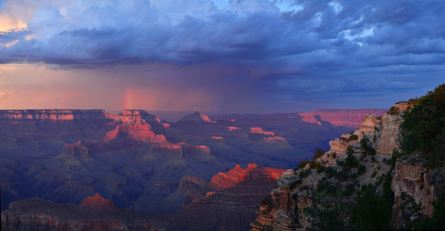
Sunset over the South Rim of the Grand Canyon. Photo © Grand Canyon National Park Service, licensed Creative Commons Attribution.
The park’s South Rim has two entrances, both located along Highway 64. Most visitors arrive via the larger South Entrance, accessible from Flagstaff or Williams. It seems like every couple of years the park adds more lanes to reduce waiting lines; still, traffic often backs up during summer weekends and holidays. But there are ways you can avoid idling in traffic on a sizzling summer afternoon. First, plan your arrival for the cooler, less busy morning or evening hours. Second, if you already have a Grand Canyon annual pass or an Interagency pass, you can skip the longest lines and use the special entry lane for prepaid fees. You can also use this faster lane if you prepay at the National Geographic Visitors Center (home of the Grand Canyon IMAX movie) in Tusayan, a mere two miles south of the entrance, or in the gateway city of Williams.The East Entrance Station at Desert View is smaller than the South Entrance and receives far fewer visitors. About 30 miles east of Grand Canyon Village, the East Entrance Station is accessible via U.S. 89 and Highway 64. It adds a few miles to the drive from Flagstaff, but you can start off your visit to the canyon by exploring the East Rim overlooks on your way to Grand Canyon Village, arriving just about the time you can check into your room at the lodge.
When you enter, the ranger working the entry booth will hand you a copy of The Guide, the park’s official newspaper. The South Rim edition is updated each spring, summer, and winter, listing current ranger programs, special events, sunrise and sunset times, and other helpful information, including the all-important map of parking areas and shuttle stops.
Historic Hermit Road has seasonal restrictions on personal vehicles. Most of the year, free shuttle buses on the Hermits Rest Route leave every 15–30 minutes and stop at all the West Rim overlooks. You can get out and snap photos, catching the next shuttle bus or walking the Rim Trail to the next shuttle stop. You can also explore Hermit Road by Harveycar, one of the guided motor coach tours operated by Xanterra Parks & Resorts. Either way, you can gawk at the views without worrying about the winding road. If you’re sitting on the right-hand side of the bus, you’ll be able to gaze out at the canyon during much of the ride to Hermits Rest.
The drive begins just west of Bright Angel Lodge, traveling between the canyon and the piñon-juniper woodland that characterizes much of the South Rim.From December through February, Hermit Road is open to passenger cars (weather permitting). The drive begins just west of Bright Angel Lodge, traveling between the canyon and the piñon-juniper woodland that characterizes much of the South Rim. From either of two Trailview Overlooks, you’ll have outstanding views of the historic village and Bright Angel Trail.Continuing on Hermit Road, about 1.5 miles from the village Maricopa Point is marked by the tram tower that once served the Lost Orphan Mine, which yielded copper and later uranium but ceased operations in the 1960s. Far below, the Inner Gorge reveals the oldest rocks in Grand Canyon, Zoroaster granite (pink) and Vishnu schist (gray-black). The formation below the rim to the right is known as the Battleship.
The memorial at Powell Point, two miles from the village, honors John Wesley Powell, the one-armed Civil War veteran who led the first expeditions down the Colorado River through Grand Canyon in 1869 and 1872.
The views from Hopi Point, the northernmost point on the South Rim, encompass the Palisades of the Desert to the east all the way to Havasupai Point on the west. It’s a panorama nearly 100 miles wide, making this one of the most popular overlooks for viewing sunrise or sunset.
The Colorado River stretches in either direction far below Mohave Point, three miles west of the village. Three rapids—Hermit, Salt Creek, and Granite—are visible from this overlook. You might even be able to hear Hermit Rapids, the farthest west, formed by debris from Hermit Canyon.
A mile farther down Hermit Road, The Abyss marks one of the steepest drops from the canyon rim. The Great Mohave Wall, a sheer cliff of sandstone and limestone, plunges nearly 4,000 feet down to Monument Creek and Monument Canyon, named for the pillars found in its depth.
Pima Point is farther off the main road than the other overlooks, making it a good place to pause and enjoy the natural quiet. In addition to a sweeping panorama across the canyon, taking in the North Rim from Powell Plateau to Cape Royal, you can see the crumbling foundations of historic Hermit Camp below.
Built in 1914 as a rest stop for tourists traveling the West Rim stage, Hermits Rest was designed by architect Mary Colter. Inspired by Louis Boucher, a prospector who lived at Grand Canyon in the 1890s, Colter imagined the building as a cavern-like refuge carved out of the cliffs. The arched fireplace is 12 feet high and nearly 10 feet deep. It’s said that Colter—who had a reputation for being a stern taskmaster—liked to relax on a natural limestone seat below the building. Just west of Hermits Rest, Hermit Trail begins its nearly 10-mile descent to the Colorado River. You’ll find restrooms, a snack bar, and a gift shop at Hermits Rest, a National Historic Landmark.
South of Grand Canyon Visitors Center, Highway 64 turns east for Desert View Drive, a scenic 23-mile stretch along the East Rim. This good paved road is open to personal vehicles year-round, though snow sometimes forces road closures for brief periods in the winter. From Pipe Creek Vista to Desert View, the road climbs through ponderosa forest to the South Rim’s highest elevations. If you don’t have a car, Xanterra Parks & Resorts offers guided bus tours along this route. The East Rim is much quieter than the Grand Canyon Village and Hermit Road areas—sweet relief from summer sun and summer crowds.
The paved turnout just past the intersection is Pipe Creek Vista. Stop for a good view of the central canyon, including Plateau Point and O’Neill Butte, though the views aren’t as fine as from Yaki Point. Since Yaki Point is closed to private vehicles, many people make do with this easily accessed viewpoint marking the end of the Rim Trail.
Twelve miles east of the village, Grandview Point is one of the South Rim’s highest overlooks at nearly 7,400 feet. Surrounded by quiet ponderosa pine forest, it’s hard to believe this was once the hot spot at Grand Canyon and home to a hotel, tent cabins, and a mining operation centered on Horseshoe Mesa, visible below the rim. The Grandview Trail starts at the east end of the stone barrier and leads to the mesa 3,000 feet below.
About three miles past Grandview, you’ll see the Buggeln picnic area, a shady and peaceful place for lunch. Although the rim is brushy here, you can walk through the forest for glimpses of the Sinking Ship, a rock formation that tilts back toward the rim.
Moran Point, overlooking Red Canyon, is one of the few rim overlooks that wasn’t named for a North American Indian tribe. Moran Point honors artist Thomas Moran, who captured the canyon’s dramatic vistas in drawings and paintings, including Chasm of the Colorado, which hung in the U.S. Capitol building in Washington, D.C., for many years. Moran was a member of explorer John Wesley Powell’s third canyon expedition in 1873. His assignment was to sketch scenes that would be converted to engravings for magazine articles about the canyon.
Tusayan Ruins, 25 miles east of the village, was inhabited 800 years ago. This masonry complex of rooms sheltered about 30 people who farmed nearby in the summer, migrating to the canyon’s floor in the winter. Rangers guide daily walks of the ruins. The adjacent museum highlights prehistoric and contemporary Native American cultures of the region and houses a small Grand Canyon Association bookstore. Restrooms are located just west of the building.
Lipan Point has one of the East Rim’s best views, taking in the canyon from its turn west at the Palisades of the Desert to the Inner Gorge. Across the canyon is Cape Royal, and below it the rocks of the Grand Canyon Supergroup: soft, colorful layers carved into the hills and valleys above the river’s Unkar Delta. Nearby, the challenging Tanner Trail leads to the river.
Navajo Point also has fine views of the colorful Supergroup layers. In 1540, Hopi guides led a detachment from Francisco Vásquez de Coronado’s expedition to the rim of Grand Canyon somewhere in the vicinity of Navajo, Lipan, or Moran Points. Nearby, Hopi trails led into the canyon to sites that they still consider sacred today. We can imagine that the Hopi guides watched silently—and perhaps with some amusement—as the Spanish explorers tried to reach the river, a frustrating and failed endeavor they recorded in expedition journals.
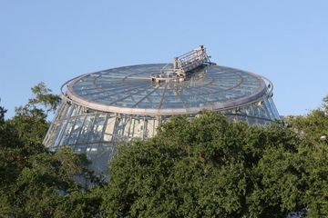
Desert View, the easternmost overlook inside the park, offers views of the Colorado River as it exits Marble Canyon and bends west toward the Inner Gorge. Nearby is the park’s East Entrance Station along with a campground, a gas station, a general store, a snack bar, and a bookstore. The highlight is Mary Colter’s fabulous Watchtower, inspired by the Ancestral Puebloans (also known as the Anasazi). From the top of the 70-foot tower, you can look east to the Painted Desert.
Excerpted from the Fifth Edition of Moon Grand Canyon.