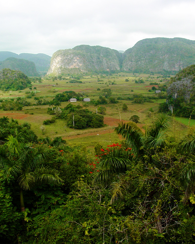
Limestone mogotes jut out of the ground in beautiful Valle de Viñales. Photo © Ryan Ready, licensed Creative Commons Attribution.
Cuba lies at the western end of the Greater Antilles group of Caribbean islands, which began to heave from the sea about 150 million years ago. Curling east and south like a shepherd’s crook are the much younger and smaller mostly volcanic Lesser Antilles, which bear little resemblance to their larger neighbor. Cuba is by far the largest of the Caribbean islands at 110,860 square kilometers. It is only slightly smaller than the state of Louisiana and half the size of the United Kingdom.Cuba is by far the largest of the Caribbean islands at 110,860 square kilometers. It is only slightly smaller than the state of Louisiana and half the size of the United Kingdom. It sits just south of the Tropic of Cancer at the eastern perimeter of the Gulf of Mexico, 150 kilometers south of Key West, Florida, 140 kilometers north of Jamaica, and 210 kilometers east of Mexico’s Yucatán Peninsula. It is separated from Hispaniola to the east by the narrow, 77-kilometer-wide Windward Passage.Cuba is actually an archipelago with some 4,000-plus islands and cays dominated by the main island (104,945 square kilometers), which is 1,250 kilometers long—from Cabo de San Antonio in the west to Punta Maisí in the east—and between 31 and 193 kilometers wide. Plains cover almost two-thirds of the island. Indeed, Cuba is the least mountainous of the Greater Antilles, with a median elevation of less than 100 meters above sea level.
Slung beneath the mainland’s underbelly is Isla de la Juventud (2,200 square kilometers), the westernmost of a chain of smaller islands—the Archipiélago de los Canarreos—which extends eastward for 110 kilometers across the Golfo de Batabanó. Farther east, beneath east-central Cuba, is a shoal group of tiny coral cays—the Archipiélago de los Jardines de la Reina—poking up a mere four or five meters from the sapphire sea. The central north coast is rimmed by a necklace of coral jewels limned by sand like crushed sugar shelving into bright turquoise shallows, with surf pounding on the reef edge.
The fecund flatlands are disjoined by three mountain zones, where the air is cool and inviting and the roads dip and rise through very untropical-looking countryside. The westernmost mountains are the slender, low-slung Sierra del Rosario and Sierra de los Órganos, which together constitute the Cordillera de Guaniguanico, forming a backbone along the length of northern Pinar del Río Province. In their midst is the striking Valle de Viñales, a classic karst landscape of limestone formations called mogotes.
The Sierra Escambray rises steeply over west-central Cuba, dominating eastern Cienfuegos and southern Villa Clara Provinces. A third mountain zone, incorporating several adjacent ranges, overshadows the provinces of Granma, Santiago de Cuba, and Guantánamo and spills over into Holguín Province. To the west, the precipitous Sierra Maestra rises steeply from the sea, culminating atop Pico Turquino (1,974 meters), Cuba’s highest mountain. To the east are the Cuchillas de Toa, Sierra de Puriscal, and Sierra de Cristal.
Cuba has more than 400 beaches in shades of oyster white, chocolate brown, gold, and taupe. The most beautiful line the ocean side of the innumerable coral cays beaded like pearls off the north coast. Most beaches along the south coast can’t compare; exceptions include Playa Ancón and Cayo Largo. The north coast is indented by huge, flask-shaped bays, not least Bahía de Habana, on whose western shores grew Havana.
Cuba has over 500 rivers, most of them short, shallow, and unnavigable. The principal river, the 370-kilometer-long Río Cauto, which originates in the Sierra Maestra and flows northwest, is navigable by boat for about 80 kilometers. Most rivers dwindle to trickles in the dry season, then swell to rushing torrents, flooding extensive areas on the plains when the rains come in summer. Cuba is studded with huge artificial reservoirs.
Excerpted from the Fifth Edition of Moon Cuba.