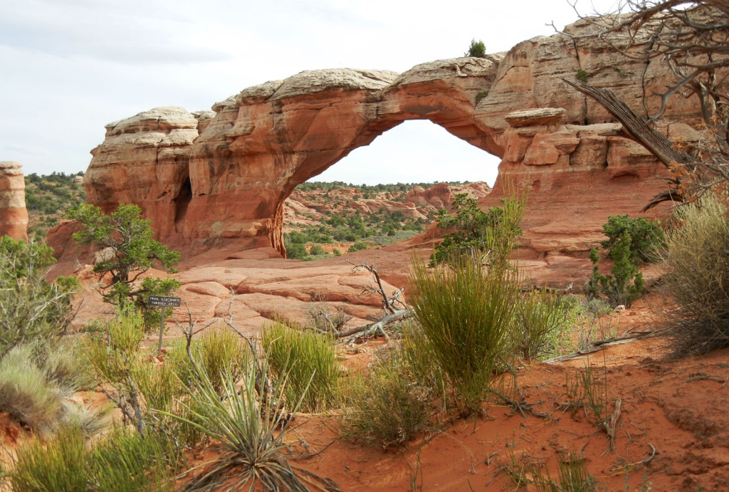
There are over 2,000 natural sandstone arches in the park. Photo © Judy Jewell.
A concentration of rock arches of marvelous variety has formed within the maze of sandstone fins at Arches National Park, one of the most popular national parks in the United States. Balanced rocks and tall spires add to the splendor. Paved roads and short hiking trails provide easy access to some of the more than 1,500 arches in the park. If you’re short on time, a drive through the Windows Section (23.5 miles round-trip) affords a look at some of the largest and most spectacular arches. To visit all the stops and hike a few short trails takes a full day. A full day in the park allows plenty of time to stop at the visitors center and then hike the full Delicate Arch Trail and explore Devils Garden.Most of the early settlers and cowboys who passed through the Arches area paid little attention to the scenery. In 1923, however, a prospector by the name of Alexander Ringhoffer interested officials of the Rio Grande Railroad in the scenic attractions at what he called Devils Garden, now known as Klondike Bluffs. The railroad people liked the area and contacted Stephen Mather, the first director of the National Park Service. Mather started the political process that led to designating two small areas as a national monument in 1929, but Ringhoffer’s Devils Garden wasn’t included until later. The monument grew in size over the years and became Arches National Park in 1971. The park now comprises 76,519 acres—small enough to be appreciated in one day, yet large enough to warrant extensive exploration.Thanks to unrelenting erosion, the arches themselves are constantly changing. Every so often there’s a dramatic change, as there was during the summer of 2008 when Wall Arch, a 71-foot span on the Devils Garden Trail, collapsed.
If you only have part of the day to explore, drive the 18-mile length of the main park road with brief stops at Balanced Rock and the Delicate Arch viewpoint. At the road’s end, set out on the Devils Garden Trail, but take only the trip to Tunnel and Pine Tree Arches. If you still have some time, stop on the way back out of the park and take a stroll on the Park Avenue Trail.
A full day in the park allows plenty of time to stop at the visitors center and then hike the full Delicate Arch Trail and explore Devils Garden. Energetic hikers may want to do the entire 7.2-mile loop in Devils Garden; those who want less of a workout can walk the onemile- long trail to Landscape Arch.
If you have more than one day to spend, plan ahead and register online for a ranger-led hike into the Fiery Furnace area of the park. This takes about half a day; for the other half, head out via car or mountain bike to Tower Arch Trail.
Although Arches is known more for day hiking than backpacking, park rangers can help you put together a backpacking trip and issue the required backcountry permit.
The entrance to Arches National Park (435/719-2299, $10 per vehicle, $5 bicyclists, motorcyclists, and pedestrians) is five miles north of downtown Moab on U.S. 191.
Visitors CenterLocated just past the park entrance booth, the expansive visitors center (7:30am-6:30pm daily Apr.-Oct., 8am-4:30pm daily Nov.-Mar.) provides a good introduction to what you can expect ahead. Exhibits identify the rock layers, describe the geologic and human history, and illustrate some of the wildlife and plants of the park. A large outdoor plaza is a good place to troll for information when the visitors center is closed.
A short slide program runs regularly, and staff members are available to answer your questions, issue backcountry permits, and check you in for a ranger-led tour in the Fiery Furnace area of the park. Look for the posted list of special activities; rangers host campfire programs and lead a wide variety of guided walks April-September. You’ll also find checklists, pamphlets, books, maps, posters, postcards, and film for purchase. See the rangers for advice and the free backcountry permit required for overnight trips. The easy 0.2-mile Desert Nature Trail begins near the visitors center and identifies some of the native plants. Picnic areas are outside the visitors center and at Balanced Rock and Devils Garden.
Desert bighorn sheep frequent the area around the visitors center and can sometimes be seen from U.S. 191 just south of the park entrance. A sheep crossing about three miles north of the visitors center is also a good place to scan the steep talus slopes for these nimble animals. A road guide to Arches National Park, available at the visitors center, has detailed descriptions that correspond to place-names along the main road. Be sure to stop only in parking lots and designated pullouts. Watch out for others who are sightseeing in this popular park. With less than 30 miles of paved road, the traffic can be surprisingly heavy in the summer high season.
If your plans include visiting Canyonlands National Park plus Hovenweep and Natural Bridges National Monuments, consider the socalled Local Passport ($25), which buys entry to all of these federal preserves. Purchase the pass at any of the park or national monument entrances.
Moab Fault
The park road begins a long but well-graded climb from the visitors center up the cliffs to the northeast. A pullout on the right after 1.1 miles offers a good view of Moab Canyon and its geology. The rock layers on this side of the canyon have slipped down more than 2,600 feet in relation to the other side. Movement took place about six million years ago along the Moab Fault, which follows the canyon floor. Rock layers at the top of the far cliffs are nearly the same age as those at the bottom on this side. If you could stack the rocks of this side on top of rocks on the other side, you’d have a complete stratigraphic column of the Moab area— more than 150 million years’ worth.
Park Avenue
South Park Avenue overlook and trailhead are on the left 2.1 miles from the visitors center. Great sandstone slabs form a skyline on each side of this dry wash. A trail goes north one mile down the wash to the North Park Avenue trailhead (1.3 miles ahead by road). Arrange to be picked up there, or backtrack to your starting point. The large rock monoliths of Courthouse Towers rise north of Park Avenue. Only a few small arches exist now, although major arches may have formed there in the past.
Balanced Rock (Moon Recommended)
This gravity-defying formation is on the right, 8.5 miles from the visitors center. A boulder more than 55 feet high rests precariously atop a 73-foot pedestal. Chip Off the Old Block, a much smaller version of Balanced Rock, stood nearby until it collapsed in the winter of 1975-1976. For a closer look at Balanced Rock, take the 0.3-mile trail encircling it. There’s a picnic area across the road. Author Edward Abbey lived in a trailer near Balanced Rock for a season as a park ranger in the 1950s; his journal became the basis for the classic Desert Solitaire.
Windows Section (Moon Recommended)
The Windows Section of Arches is located 2.5 miles past Balanced Rock, on a paved road to the right. Short trails (0.25-1 mile oneway) lead from the road’s end to some massive arches. Windows trailhead is the start for North Window (an opening 51 feet high and 93 feet wide), South Window (66 feet high and 105 feet wide), and Turret Arch (64 feet high and 39 feet wide). Double Arch, a short walk from a second trailhead, is an unusual pair of arches; the larger opening—105 feet high and 163 feet wide—is best appreciated by walking inside. The smaller opening is 61 feet high and 60 feet wide. Together, the two arches frame a large opening overhead.
Garden of Eden Viewpoint, on the way back to the main road, promises a good panorama of Salt Valley to the north. Under the valley, the massive body of salt and gypsum that’s responsible for the arches comes close to the surface. Far-off Delicate Arch can be seen across the valley on a sandstone ridge. Early visitors to the Garden of Eden saw rock formations resembling Adam (with an apple) and Eve. Two other viewpoints of the Salt Valley area lie farther north on the main road.
Delicate Arch and Wolfe Ranch
A bit of pioneer history survives at Wolfe Ranch, 2.5 miles north on the main road from the Windows junction (turn right and drive 1.8 miles to the parking area). John Wesley Wolfe came to this spot in 1888, hoping the desert climate would provide relief for health problems related to a Civil War injury. He found a good spring high in the rocks, grass for cattle, and water in Salt Wash to irrigate a garden. The ranch that he built provided a home for him and some of his family for more than 20 years, and cattlemen later used it as a line ranch. Then sheepherders brought in their animals, which so overgrazed the range that the grass has yet to recover. A trail guide available at the entrance tells about the Wolfe family and the features of their ranch. The weather-beaten cabin built in 1906 still survives. A short trail leads to petroglyphs above Wolfe Ranch; figures of horses indicate that Ute people, rather than earlier inhabitants, did the artwork. Park staff can give directions to other rock-art sites; great care should be taken not to touch the fragile artwork.
Delicate Arch stands in a magnificent setting atop gracefully curving slickrock. Distant canyons and the La Sal Mountains lie beyond. The span is 45 feet high and 33 feet wide. A moderately strenuous three-mile round-trip hike leads to the arch. Another perspective on Delicate Arch can be obtained by driving 1.2 miles beyond Wolfe Ranch. Look for the small arch high above. A short, steep trail (0.5 miles round-trip) climbs a hill for the best view.
Fiery Furnace
The Fiery Furnace Viewpoint and trailhead are three miles from the Wolfe Ranch junction, on the right side of the main road. The Fiery Furnace gets its name from sandstone fins that turn flaming red on occasions when thin cloud cover at the horizon reflects the warm light of sunrise or sunset. The shady recesses beneath the fins provide a cool respite from the hot summer sun.
Closely packed sandstone fins form a maze of deep slots, with many arches and at least one natural bridge inside. Both for safety reasons and to reduce human impact on this sensitive area, which harbors several species of rare plants, hikers are encouraged to join a rangerled hike. The hike is moderately strenuous and involves steep ledges, squeezing through narrow cracks, a couple of jumps, and hoisting yourself up off the ground. There is no turning back once the hike starts, so make sure you’re physically prepared and properly equipped.
Rangers lead three-hour hikes (Mar.-Oct., $10 adults, $5 ages 5-12 and Interagency Senior Pass holders) into the Fiery Furnace twice each day. Unlike most ranger-led activities, a fee is charged for these hikes. Group size is limited to about 20 people, and it is not recommended for children under age five. Walks often fill weeks in advance. Make reservations online at www. recreation.gov or in person at the visitors center up to seven days in advance. To visit the Fiery Furnace without a ranger, visitors must obtain a permit ($5 pp) at the visitors center. A couple of Moab outfitters also lead hikes into the Fiery Furnace; these cost considerably more, but there’s usually space available.
Skyline Arch
This arch is on the right, one mile past the Sand Dune/Broken Arch trailhead. In desert climates, erosion can proceed imperceptibly for centuries until a cataclysmic event happens. In 1940 a giant boulder fell from the opening of Skyline Arch, doubling the size of the arch in seconds. The hole is now 45 feet high and 69 feet wide. A short trail leads to the base of the arch.
Devils Garden
The Devils Garden trailhead, picnic area, and campground are all near the end of the main park road. Devils Garden offers fine scenery and more arches than any other section of the park. The hiking trail leads past large sandstone fins to Landscape and six other named arches. Carry water if the weather is hot or if you might want to continue past the one-mile point at Landscape Arch. Adventurous hikers could spend days exploring the maze of canyons among the fins.
Klondike Bluffs and Tower Arch
Relatively few visitors come to the spires, high bluffs, and fine arch in this northwestern section of the park. A fair-weather dirt road turns off the main drive 1.3 miles before Devils Garden trailhead, winds down into Salt Valley, and heads northwest. After 7.5 miles, turn left on the road to Klondike Bluffs and proceed one mile to the Tower Arch trailhead. These roads may have washboards, but they are usually passable by cars in dry weather; don’t drive on them if storms threaten. The trail to Tower Arch winds past the Marching Men and other rock formations (3 miles roundtrip). Alexander Ringhoffer, who discovered the arch in 1922, carved an inscription on the south column. The area can also be fun to explore off-trail with a map and compass or a GPS receiver. Those with 4WD vehicles can drive close to the arch on a separate jeep road. Tower Arch has an opening 34 feet high by 92 feet wide. A tall monolith nearby gave the arch its name.
4WD Road
A rough road near Tower Arch in the Klondike Bluffs turns southeast past Eye of the Whale Arch in Herdina Park to Balanced Rock on the main park road, 10.8 miles away. The road isn’t particularly difficult for 4WD enthusiasts, although normal backcountry precautions should be taken. A steep sand hill north of Eye of the Whale Arch is difficult to climb for vehicles coming from Balanced Rock; it’s better to drive from the Tower Arch area instead.
Excerpted from the Fifth Edition of Moon Zion & Bryce.