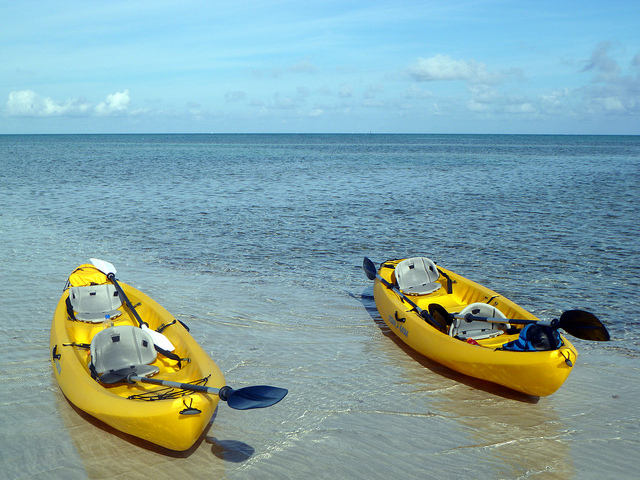
Kayaks on the beach. Photo © David Berkowitz, licensed Creative Commons Attribution.
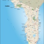
The Great Calusa Blueway Paddling Trail is a 100-mile mapped-and-markered route for paddlers of all skill levels to explore. Following the trail of the area’s early fishermen, the Calusa people, it runs along Lee County’s coastal waters from Cayo Costa and Charlotte Harbor south through Pine Island Sound and Matlacha Pass to Estero Bay and the Imperial River in Bonita Springs.If you’re not an outdoorsy type whose idea of fun is an Eskimo roll in fierce white water, you can enjoy a couple of days of nice, easy kayaking, with stops for lunch and bird-watching, and a comfy bed at the end of each day.
Outfitters offer guided trips (even some moonlight excursions), and there are numerous rentals and launch areas if you want to head out on your own.The website Great Calusa Blueway Paddling Trail gives details on the routes, what you’ll see along the way, where to launch or stop, maps, GPS coordinates, and more, but you will still need to pick up a kayak or canoe. Outfitters offer guided trips (even some moonlight excursions), and there are numerous rentals and launch areas if you want to head out on your own.You start the first day on the Pine Island Sound–Matlacha Pass section of the paddling trail. Crunching over the gravel at the Fish House Marina, you find your way to Gulf Coast Kayak (4530 Pine Island Rd., Matlacha, 239/283-1125, single kayak $30 half day, $40 full day). You get paddles, life jackets, trail maps, and kayaks and put in just at the drawbridge at Matlacha Pass.
The second segment to be mapped, the Pine Island Sound trail is gentle and sheltered. You can see small black crabs scoot along red mangrove trunks, and great blue herons wade in their shade as you meander through backwaters and mangrove tunnels from marker 84 to marker 89. A few hours later you realize paddling makes you hungry.
From here you head back down through Buzzard Bay until you reemerge at the Old Fish House. Lunch here is local shrimp quesadillas, local smoked mullet, and a novelty food: fried mullet gizzard (it seems that the mullet, mostly vegetarian, is like a chicken in that it has no stomach but a crop and a gizzard). Order at the counter, eat at picnic tables, and watch the snook and needlenose gar churn the water down below.
On day two you put in at Fort Myers Beach, which is actually on the island of Estero, connected to Fort Myers by a causeway. There are several worthwhile beaches here (Bowditch Point Regional Park, Lynn Hall Memorial Park), but we set our sights on Lovers Key State Park (8700 Estero Blvd., Fort Myers Beach, 239/463-4588, 8 a.m.–sundown, $8/ car up to eight people, $4 single occupancy car, $2 pedestrians and bicyclists), another key embarkation point on the Great Calusa Blueway.
From here you head to the Nature Recreation Management concessionaire (239/765-7788, single kayak $20 for half day), pick up paddles and gear, then headed to the launch spot to put in your kayaks. Using a Blueway map, you can make your way from marker 8 to markers 13 and 22. In parts the water is shallow, maybe a foot deep, and you quietly make your way out to congregations of ibis, egrets, and herons. If you keep paddling you can make it to Mound Key (Estero Bay, 239/992-0311, daylight hours, free), a complex of Calusa mounds made of shells, fish bones, and pottery. Thought to be a sacred ceremonial center for the native people, in 1566 it was settled by the Spanish and became the site of the first Jesuit mission in the Spanish New World. That didn’t last long, as the Calusa weren’t thrilled with the settlers.
The shell construction contains mounded platforms, ceremonial mounds, ridges, substantial carved-out canals, and open water courts—evidence of a fairly elaborate community some 2,000 years ago. There are not a lot of interpretive markers or signs here, but it’s a nice place for a picnic.
Adventure Sea Kayak (’Tween Waters Inn Marina, 14000 Captiva Dr., Captiva, 239/822-3337, $40/person) conducts kayak tours, its specialty being interactive trips that focus on the wildlife, ecology, and history of the barrier islands. Also based in Captiva, Captiva Kayak Company & Wildside Adventures (11401 Andy Rosse Ln. at bayside McCarthy’s Marina, Captiva, 239/395-2925) offers rentals, instruction, and sunrise, sunset, and starlight tours. On Sanibel, Tarpon Bay Explorers (900 Tarpon Bay Rd., Sanibel, 239/472-8900, $15–180) has a range of services, from canoe, kayak, and bike rentals to guided tours. And if you just want to rent a kayak or canoe, try Gulf Coast Kayak (4530 Pine Island Rd., Matlacha, 239/283-1125, single kayak or canoe $30 half day, $40 full day) or farther south with Estero River Canoe & Tackle Outfitters (20991 S. Tamiami Trail, Estero, 239/992-4050), which offers 300 canoes and kayaks, all different kinds.
Excerpted from the Fourth Edition of Moon Florida Gulf Coast.