Founded in 1972, Parque Nacional Santa Rosa was the country’s first national park. The 49,515-hectare (122,354-acre) park covers much of the Santa Elena peninsula and is part of a mosaic of ecologically interdependent parks and reserves—the 110,000-hectare (272,000-acre) Área de Conservación Guanacaste. Parque Nacional Santa Rosa is most famous for Hacienda Santa Rosa—better known as La Casona—the nation’s most cherished historic monument. It was here in 1856 that the mercenary army of American adventurer William Walker was defeated by a ragamuffin army of Costa Rican volunteers.
At night, plankton light up with a brilliant phosphorescence as you walk the drying sand in the wake of high tide.The park is a mosaic of 10 distinct habitats, including mangrove swamp, savanna, and oak forest, which attract more than 250 bird species and 115 mammal species (half of them bats, including two vampire species), among them relatively easily seen animals such as white-tailed deer; coatimundis; howler, spider, and white-faced monkeys; and anteaters. In the wet season, the land is as green as emeralds, and the wildlife disperses. In dry season, however, wildlife congregates at watering holes and is easily spotted. Jaguars, margays, ocelots, pumas, and jaguarundis are here but are seldom seen. Santa Rosa is a vitally important nesting site for olive ridleys and other turtle species.![Beach in Parque Nacional Santa Rosa. Photo © <a href="http://www.flickr.com/photos/dejeuxx/5677047841/">Geoff Gallice</a> [<a href="http://creativecommons.org/licenses/by/2.0">CC BY 2.0</a>], <a href="https://commons.wikimedia.org/wiki/File%3ASanta_Rosa_National_Park.jpg">via Wikimedia Commons</a>](https://www.holidaytravel.cc/Article/UploadFiles/201602/2016021614524829.jpg)
Beach in Parque Nacional Santa Rosa. Photo © Geoff Gallice [CC BY 2.0], via Wikimedia Commons
The park is divided into two sections: the more important and accessible Santa Rosa Sector to the south (the entrance is at Km. 269 on Hwy. 1, about 37 kilometers/23 miles north of Liberia) and the Murciélago Sector (the turnoff from Hwy. 1 is 10 kilometers/6 miles farther north, via Cuajiniquil), separated by a swath of privately owned land.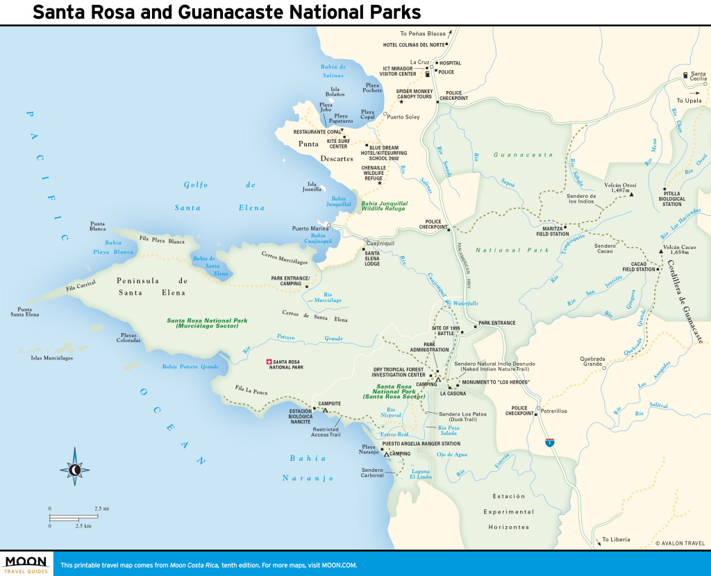
Santa Rosa and Guanacaste National Parks
From the entrance gate, the paved road leads six kilometers (4 miles) to La Casona, a magnificent colonial homestead (actually, it’s a replica, rebuilt in 2001 after arsonists burned down the original) overlooking a stone corral where the battle with William Walker was fought. The fire destroyed the antique furnishings and collection of photos, illustrations, carbines, and other military paraphernalia commemorating the battle of March 20, 1856. Battles were also fought here during the 1919 Sapoá Revolution and in 1955. The garden contains rocks with petroglyphs.
The 1.5-kilometer (1-mile) Naked Indian loop trail begins just before La Casona and leads through dry forest with streams, waterfalls, and gumbo-limbo trees whose peeling red bark earned them the nickname “naked Indian trees.” Los Patos trail has watering holes and is one of the best trails for spotting mammals.
The paved road ends just beyond the administration area, near La Casona. From here, a rugged dirt road drops steeply to Playa Naranjo, 13 kilometers (8 miles). A 4WD vehicle with high ground clearance is essential, but passage is never guaranteed, not least because the Río Nisperal can be impassable in wet season (the beach is usually off-limits Aug.-Nov.). Park officials sometimes close the road and will charge you a fee if you have to be hauled out. Playa Naranjo is a beautiful kilometers-long pale-gray-sand beach that is legendary in surfing lore for its steep, powerful tubular waves and for Witch’s Rock, rising like a sentinel out of the water. The beach is bounded by craggy headlands and frequently visited by monkeys, iguanas, and other wildlife. Crocodiles lurk in mangrove swamps at the southern end of the beach. At night, plankton light up with a brilliant phosphorescence as you walk the drying sand in the wake of high tide.
![Blue Ctenosaur in Santa Rosa National Park. Photo © Jorasm (Own work) [<a href="http://creativecommons.org/licenses/by-sa/3.0">CC BY-SA 3.0</a>], <a href="https://commons.wikimedia.org/wiki/File%3ABlue_Ctenosaur.jpg">via Wikimedia Commons</a>.](https://www.holidaytravel.cc/Article/UploadFiles/201602/2016021614524854.jpg)
Blue Ctenosaur in Santa Rosa National Park. Photo © Jorasm (Own work) [CC BY-SA 3.0], via Wikimedia Commons.
The deserted white-sand Playa Nancite, about one hour’s hike over a headland from Estero Real, is renowned as a site for arribadas, the mass nestings of olive ridley turtles. More than 75,000 turtles will gather out at sea and come ashore over the space of a few days, with the possibility of up to 10,000 of them on the beach at any one time in September and October. You can usually see solitary turtles at other times August through December. Playa Nancite is a research site; access is restricted and permits are required, although anyone can get one from the ranger station or at the Dry Tropical Forest Investigation Center (Centro de los Investigaciones, tel. 506/2666-5051, ext. 233), next to the administrative center, which undertakes biological research. It is not open to visitors.Playa Potrero Grande, north of Nancite, and other beaches on the central Santa Elena peninsula offer some of the best surf in the country. The makers of Endless Summer II, the sequel to the classic surfing movie, captured the Potrero Grande break on film perfectly. You can hire a boat at any of the fishing villages in the Golfo Santa Elena to take you to Potrero Grande or Islas Murciélagos (Bat Islands), off Cabo Santa Elena, the westernmost point of the peninsula. The islands are a renowned scuba site for advanced divers.
The entrance to the Murciélago Sector of Parque Nacional Santa Rosa is 15 kilometers (9.5 miles) west of Highway 1, and 10 kilometers (6 miles) north of the Santa Rosa Sector park entrance (there’s a police checkpoint at the turnoff; have your passport ready for inspection). The road winds downhill to the hamlet of Cuajiniquil, tucked 500 meters (0.3 miles) south of the road, which continues to Bahía Cuajiniquil.
You arrive at a Y-fork in Cuajiniquil; the road to Murciélago, eight kilometers (5 miles) along, is to the left. There are three rivers to ford en route. You’ll pass the old U.S. Central Intelligence Agency training camp for the Nicaraguan Contras on the right. The site—Hacienda Murciélago—was owned by the Nicaraguan dictator Somoza’s family before being expropriated in 1979, when the Murciélago Sector was incorporated into Parque Nacional Santa Rosa. It’s now a training camp for the Costa Rican police force. Armed guards may stop you for an ID check as you pass. A few hundred meters farther, the road runs alongside the “secret” airstrip (hidden behind tall grass to the left) that Oliver North built to supply the Contras. The park entrance is 500 meters (0.3 miles) beyond.
It’s another 16 kilometers (10 miles) to Playa Blanca, a beautiful horseshoe-shaped white-sand beach about five kilometers (3 miles) wide and enjoyed only by pelicans and frigate birds. The road ends here.
Excerpted from the Tenth Edition of Moon Costa Rica.