Directly east of Temuco, 3,125-meter Volcán Llaima’s smoldering crater is Conguillío’s most eye-catching feature. Since colonial times, Chile’s second most active volcano has recorded dozens of violent eruptions. On New Year’s Day 2008, in fact, a sudden eruption and lava flow closed the northern access road from Curacautín and forced evacuation of 150 tourists.
Within its 60,833 hectares, this UNESCO biosphere reserve abounds with dozens of other lava flows, secondary cones, alpine lakes, river canyons, and the Araucaria forest that it was created to protect. The name Conguillío derives from the Mapudungun kongüjim, “to enter the pewen forest.” In late 1911, drawn by the pewen’s fame, the aging pioneer U.S. conservationist John Muir traveled here simply to see, sketch, and photograph the tree in its native habitat—”A glorious and novel sight, beyond all I had hoped for.” As he so often did in California’s Sierra Nevada, Muir slept in the open air, beneath the trees he came to visit.
For foreigners and Chileans alike, Conguillío is one of Temuco’s most popular excursions. It justifies a day trip but merits at least an overnight.

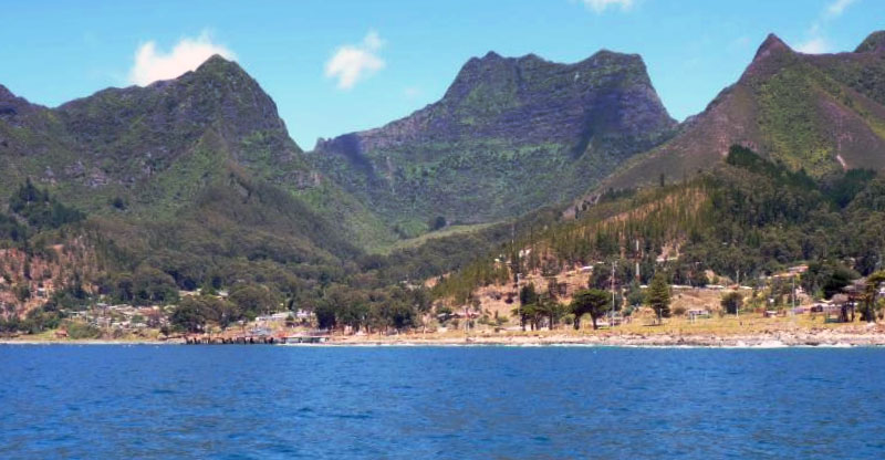
Parque Nacional Conguillío. Photo © Pato Novoa, licensed Creative Commons Attribution.
From Temuco, Conguillío’s western limit is only about 80 kilometers away via Cherquenco; by either Curacautín or Melipeuco, it’s about 120 kilometers. Altitudes range from around 900 meters in the Truful Truful valley to 3,125 meters on Llaima’s summit. In its northeastern corner, the ruggedly glaciated Sierra Nevada averages above 2,500 meters.
Since most of Conguillío’s 2,500 millimeters of precipitation falls as snow between May and September, the mild summers, averaging around 15°C, make its lakes and streams popular recreational destinations. Even in summer, occasional heavy rains—if not lava flows—can make the Curacautín road impassable even with four-wheel drive.
Towering west of the park’s geographic center, glacier-covered Volcán Llaima is a Holocene structure of accumulated lava flows within an eight-kilometer-wide caldera that exploded about 7,200 years ago. It has two active craters, one on the summit and another on its southeastern shoulder. In good weather, the northern access road is passable for normal-sized vehicles.
In Sector Conguillío, east of Llaima, the sprawling lava flows of El Escorial dammed the Río Truful Truful to form Laguna Arco Iris and Laguna Verde. To the north, beneath the Sierra Nevada, Laguna Conguillío has a similar origin.
Near Conaf’s Centro de Información Ambiental at the southwest corner of Laguna Conguillío, the Sendero Araucarias is a short woodland trail suitable for any hiker. For a longer and more challenging excursion, try walking from Playa Linda, at the east end of Laguna Conguillío, to the base of the Sierra Nevada, which offers hikers overwhelming views through nearly solid Araucaria stands. This extension across the mountains to Termas Río Blanco is a hazardous one on which hikers have died.
At Laguna Captrén, at the park’s northern entrance, the Sendero de Chile was the initial section of the nonmotorized trail intended to unite the country from the Peruvian border to Tierra del Fuego. At Laguna Arco Iris, to the south, an early settler built the wooden Casa del Colono as a homestead cabin. From Laguna Verde, also known as Laguna Quililo, a short wooded footpath reaches the beach at La Ensenada.
Conaf’s Sendero Cañadon Truful-Truful, a 900-meter nature trail, follows the river’s course where erosion has uncovered the rainbow chronology of Llaima’s eruptions and ash falls. Along the 800-meter Sendero Los Vertientes, subterranean springs emerge from the volcanic terrain.
From Sector Los Paraguas, on the park’s west side, well-equipped climbers can scale Llaima. Camping is possible in summer, and there’s also a refugio (shelter). There is an alternative route from Captrén, which has better public transport, on the north side. Before climbing, get permission from Conaf in Temuco.
Skiing takes place at Los Paraguas’s Centro de Ski Las Araucarias (tel. 045/2562313, lift tickets US$40-45 per day); it has Temuco offices (Bulnes 351, Oficina 47, tel. 045/239999).
Because public transportation is inconvenient to almost every sector of the park, it’s worth considering a car rental, but it’s not absolutely essential. Even with a car, the steep, narrow, and often muddy road between Laguna Captrén and the park administration can be difficult in either direction.
Reaching Curacautín and Melipeuco, the northern and southern gateways to the main park loop, is easy enough by public bus. From Curacautín, Curacautín Express provides twice-daily bus service, at 6am and 6pm, to the northern park entrance at Laguna Captrén. From Melipeuco, it’s possible to hire a taxi or pickup truck to get to Conguillío.
Sector Los Paraguas is most difficult to reach by public transportation as there is no bus service beyond Vilcún, 35 kilometers east; from there, it’s another 42 kilometers to the Los Paraguas ski lodge. A rugged alternative route goes from Captrén to Los Paraguas, but with no public transport.
Excerpted from the Fourth Edition of Moon Patagonia.